Hyperspectral remote sensing water depth inversion method based on deep learning

A hyperspectral remote sensing and deep learning technology, which is applied in neural learning methods, special data processing applications, instruments, etc., can solve problems such as low accuracy and constraints on the practicality and engineering application of water depth remote sensing inversion, and achieve accuracy improvement and calculation The results are reliable and credible, and the effect of broad application prospects

Pending Publication Date: 2019-04-19
BEIHANG UNIV +1
View PDF4 Cites 22 Cited by
  • Summary
  • Abstract
  • Description
  • Claims
  • Application Information

AI Technical Summary

Problems solved by technology

However, due to the influence of many interference factors such as water turbidity, water bottom reflection, wave surface reflection, remote sensor band setting and band number limitation, the current conventi...

Method used


Image

  • Hyperspectral remote sensing water depth inversion method based on deep learning
  • Hyperspectral remote sensing water depth inversion method based on deep learning
  • Hyperspectral remote sensing water depth inversion method based on deep learning

Examples


Embodiment Construction

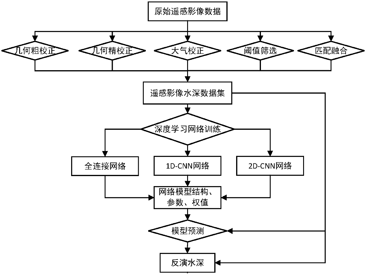
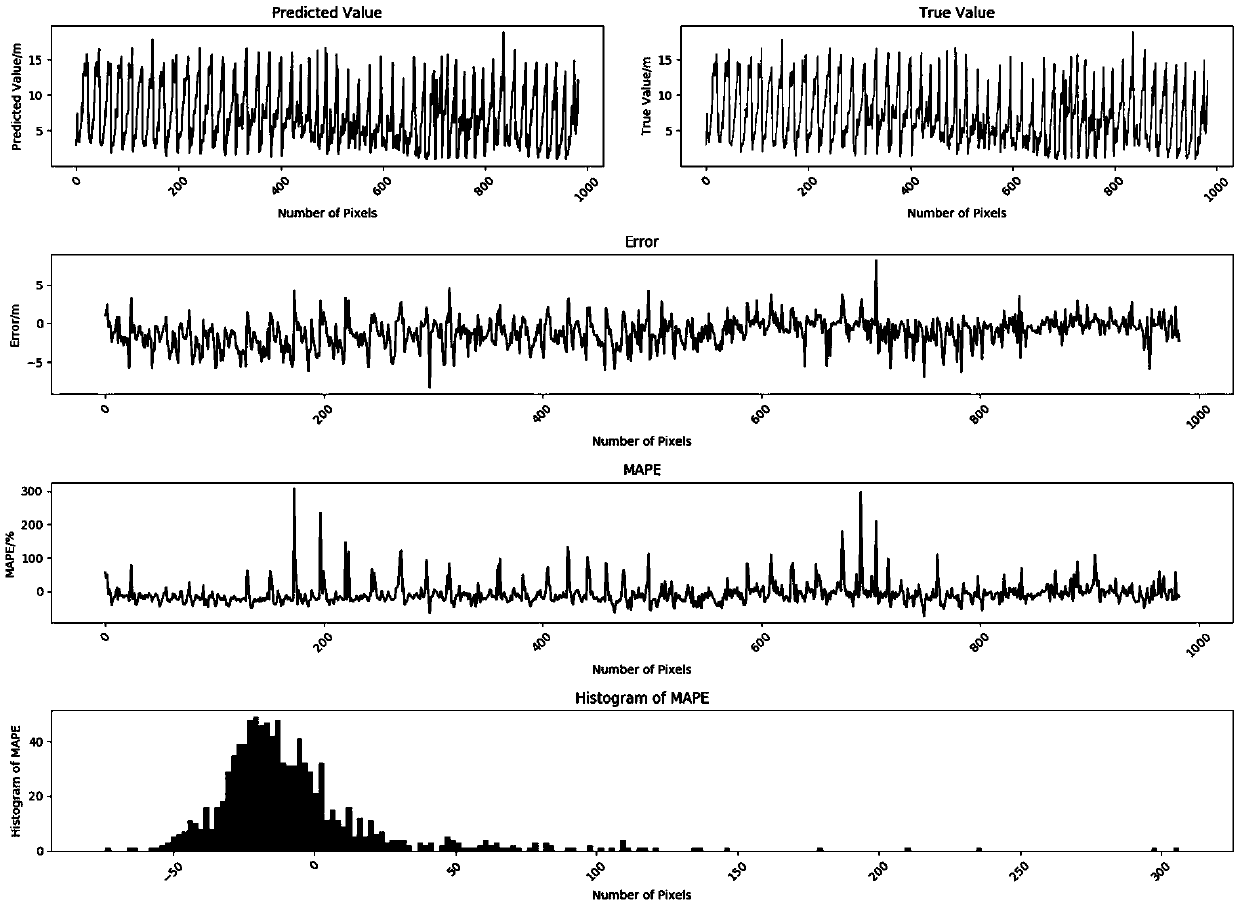
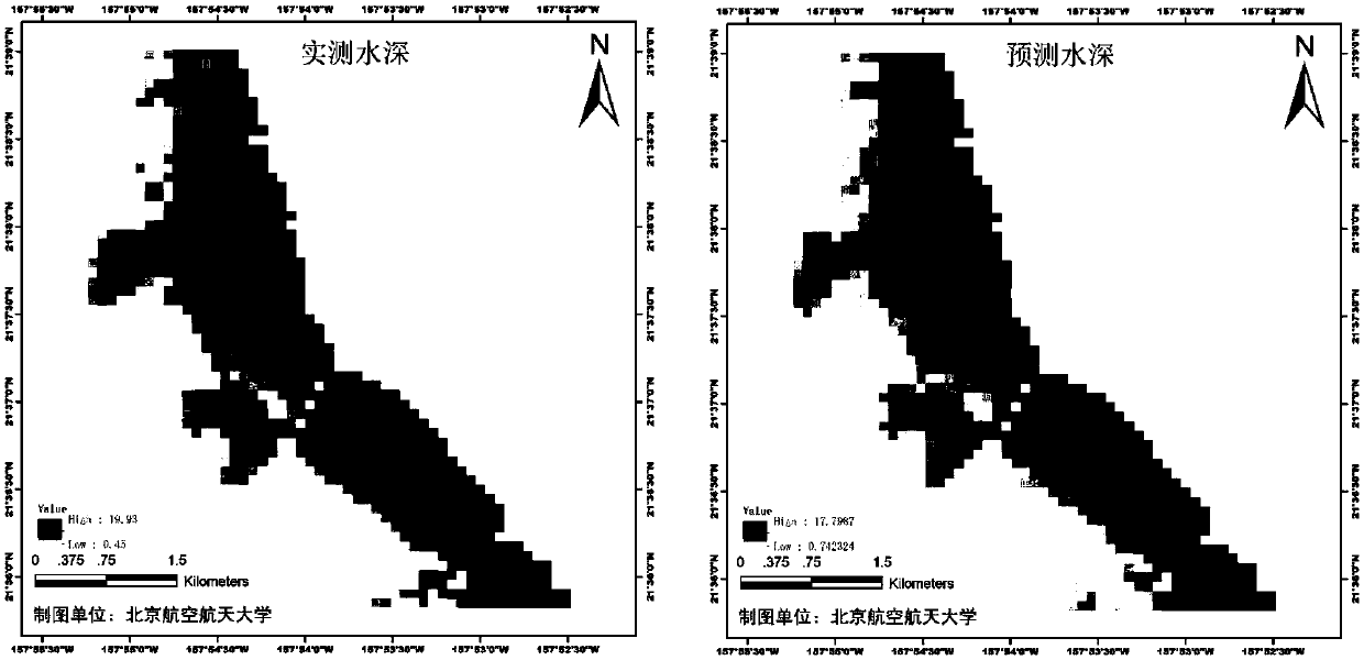
[0020] In order to better illustrate the water depth prediction method by using remote sensing parameters inversion involved in the present invention, the model of the present invention is used for testing and verification, and good results have been achieved. The specific implementation method is as follows:

[0021] (1) Taking the coastal waters of Oahu Island in the Hawaiian Islands of the United States as a demonstration research area, collect HICO hyperspectral remote sensing images in this area, and perform geometric rough correction and geometric precision on the original hyperspectral images according to the relevant preprocessing methods of remote sensing image hyperspectral images. Correction, use the FLAASH atmospheric correction module of ENVI software to perform accurate atmospheric correction on the image data to obtain the true reflectance of the ground and water surfaces;

[0022] (2) Set a threshold of 0 to 20 meters according to the topographic features of th...


PUM


Abstract

The invention relates to a hyperspectral remote sensing water depth inversion method based on deep learning, and the method comprises the following steps: carrying out geometric correction on an original hyperspectral remote sensing image of a research region, and carrying out atmospheric correction to obtain the real reflectivity of each waveband; screening an actually measured water depth rangewithin the range of 0-20 meters in the research area; clipping the remote sensing image according to the spatial range corresponding to the screened water depth data, and processing the remote sensingimage into a formatted data file; generating a formatted training data set by matching the spectral reflectivity information of the remote sensing image with the actually measured water depth data according to geographic coordinates; Using Tensorflow and Keras deep learning framework to build a fully connected neural network, 1D- CNN network, 2D-CNN network three deep learning networks to train the research area data; And respectively applying the trained network model to remote sensing image data to invert the water depth of the research area. According to the method, high-precision water depth data can be directly inverted only by taking hyperspectral remote sensing image spectral information of an optical shallow water region as input.

Description

(1) Technical field [0001] The invention relates to a hyperspectral remote sensing water depth inversion method based on deep learning, belongs to the field of optical remote sensing, and is of great significance in the research of water color remote sensing technology and deep learning technology. (2) Background technology [0002] Water depth is an important parameter of the marine environment and an important hydrological element. Coastal underwater terrain information is the basic information for coastal engineering construction, transportation, shipping, fish farming, and scientific research, and is of great significance in economic activities and natural environment protection. Coastal topography has an important impact on geological exploration, ship transportation, harbor construction, land reclamation, cable pipeline laying, coastal military engineering and other military activities, and is crucial to the economic construction and sustainable development of the coas...

Claims


Application Information

Patent Timeline
IPC IPC(8): G06F17/50G06N3/04G06N3/08
CPCG06N3/08G06F30/20G06N3/045
Inventor 周冠华张潇阳陈金勇孙康路志勇杨松
Owner BEIHANG UNIV
Why Eureka
Try Eureka