An urban land automatic identification system integrating industrial big data and building forms

An automatic identification system and automatic identification technology, applied in the field of urban land automatic identification system, can solve the problems of easy judgment, mistakes, randomness, inability to achieve precise identification of urban sub-categories, and large error coefficient of identification results. Practicality, avoid long mapping time, avoid the effect of identification error

Inactive Publication Date: 2019-05-28
SOUTHEAST UNIV
View PDF4 Cites 15 Cited by
  • Summary
  • Abstract
  • Description
  • Claims
  • Application Information

AI Technical Summary

Problems solved by technology

[0003] The current common urban land use identification methods, one is through manual on-site surveying and mapping, combined with the current topographic map, based on the results of comprehensive judgments on the buildings, business types, functions, and public spaces of each block. Large physical resources, land use identification involves human brain judgment, construction of complex plots is prone to misjudgment and larg...

Method used


Image

  • An urban land automatic identification system integrating industrial big data and building forms
  • An urban land automatic identification system integrating industrial big data and building forms
  • An urban land automatic identification system integrating industrial big data and building forms

Examples


Embodiment

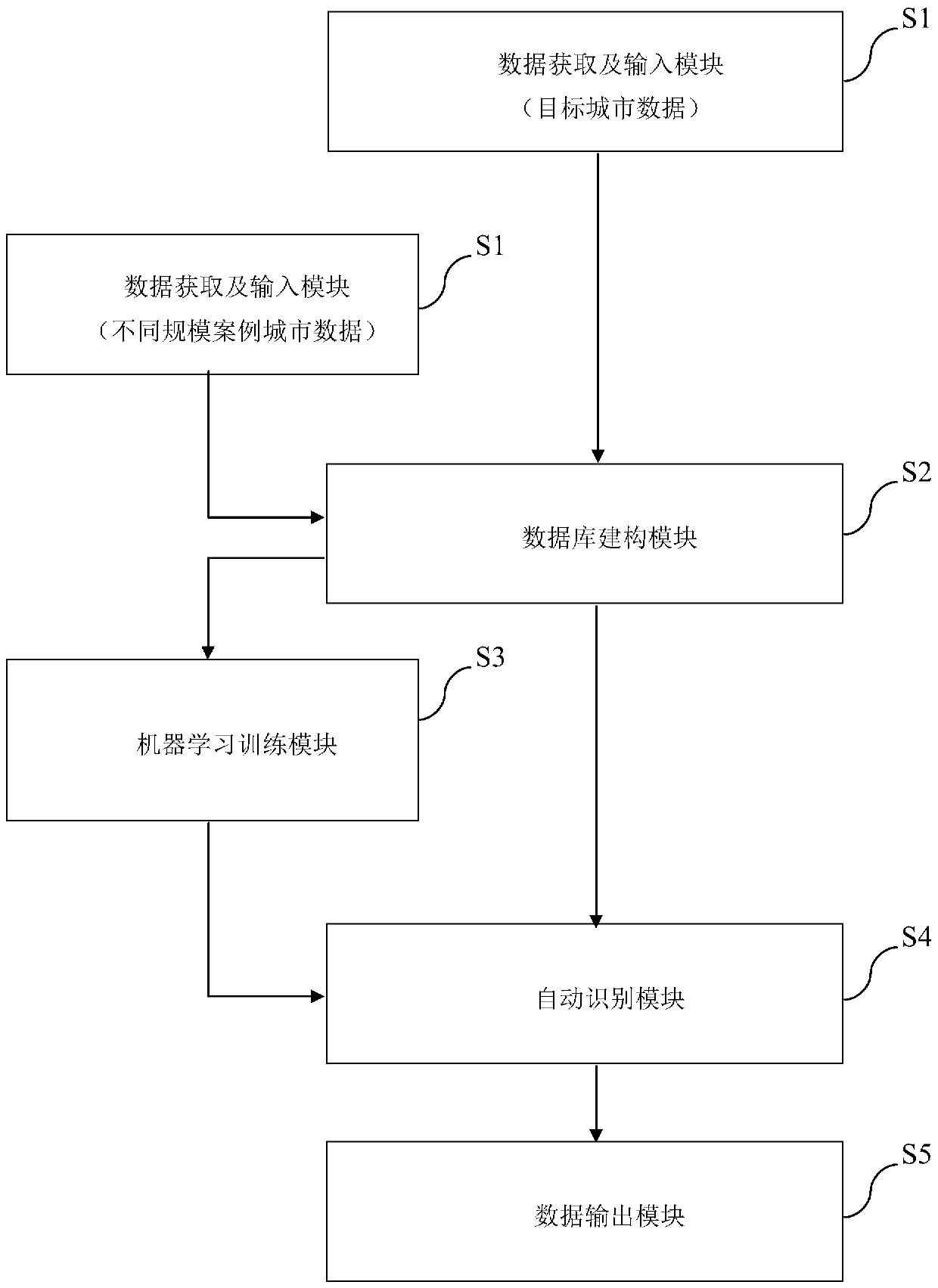
[0063] The technical solution of the present invention will be described in detail below by taking the automatic identification of urban land in Shenzhen as an example.

[0064] (1) Take Shanghai (very large-scale city), Nanjing (very large-scale city), Harbin (large-scale city), Zhenjiang (medium-scale city), Zhangjiagang (small-scale city) as five types of case cities of different scales, and take Shenzhen as the For the target city, the data acquisition and input module respectively acquires the space vector data and business point data in the built-up area of ​​each city, and enters them into the space vector platform; specifically includes:

[0065] (1.1) Obtain the spatial vector data of the above cities through the corresponding planning departments of each city, including CAD files of the current closed blocks, CAD files of the current closed land plots, CAD files of the current closed buildings and the number of floors in each city.

[0066] (1.2) Import the current c...


PUM


Abstract

The invention discloses an urban land automatic identification system integrating industrial big data and building forms. The system comprises a data acquisition and input module, a database construction module, a machine learning training module, an automatic identification module and a data output module, and the system automatically identifies urban land by extracting data distribution characteristics of urban industrial points and multi-dimensional morphological characteristics of urban space three-dimensional entities. According to the invention, determination of urban land parcel land properties in the field of urban planning and design can be handled; the high-efficiency automatic fine identification of urban land properties of different scales based on an artificial intelligence system is achieved, an efficient and convenient surveying and mapping path and reference are provided for measurement and drawing of urban current situation construction land, and the time cost of manual surveying and mapping is effectively saved.

Description

technical field [0001] The invention belongs to the field of urban planning, and relates to an automatic identification system for urban land, in particular to an automatic identification system for urban land that integrates big data of business forms and building forms. Background technique [0002] Urban land use is the planning and design basis of urban planning disciplines, and it is a collective term for land with certain uses and functions. With the rapid and stable development of urbanization and the continuous expansion of cities, the layout of urban land has become increasingly complex, which increases the difficulty and time cost of measuring the nature of urban land. On the other hand, cities of different scales and grades have obvious differences in the layout and scale of urban land plots, and the differences in business characteristics and architectural forms within the same type of land are becoming more and more obvious. Identifying the nature of urban land...

Claims


Application Information

Patent Timeline
IPC IPC(8): G06Q50/26G06N20/00G06V10/764
CPCG06Q50/26G06N20/00G06V20/176G06V10/764G06Q50/16G06F18/2431
Inventor 杨俊宴邵典王桥张宇豪曾宪涵刘志成叶晟之
Owner SOUTHEAST UNIV
Why Eureka
Try Eureka