
A system and method for quickly building geographic information data applications

A technology of geographic information data and geographic information, which is applied in the field of rapidly building geographic information data applications, and can solve problems such as application systems that cannot meet application requirements

Active Publication Date: 2021-07-02
贵州图智信息技术有限公司
View PDF4 Cites 0 Cited by
  • Summary
  • Abstract
  • Description
  • Claims
  • Application Information

AI Technical Summary

Problems solved by technology

[0002] Geographic information data is the basis of many related tasks such as urban planning, environmental protection, land survey, and road construction. From image data acquisition to business application, a series of processing procedures are required, including image correction, image registration, data fusion, and image mosaic. , block cutting, data quality inspection and many other steps. The application display of geographic information data involves factors such as map drawing, data processing, and effect rendering. Usually, the function page is customized according to application requirements. With the development of information technology With the increasing demand for social application of geographic information data, the application of geographic information data is gradually diversified, and the custom-made application systems in the past are gradually unable to meet the application requirements.

Method used


Image

  • A system and method for quickly building geographic information data applications
  • A system and method for quickly building geographic information data applications

Examples


Embodiment Construction

[0033] Specific embodiments of the present invention will be further described in detail below in conjunction with the accompanying drawings.

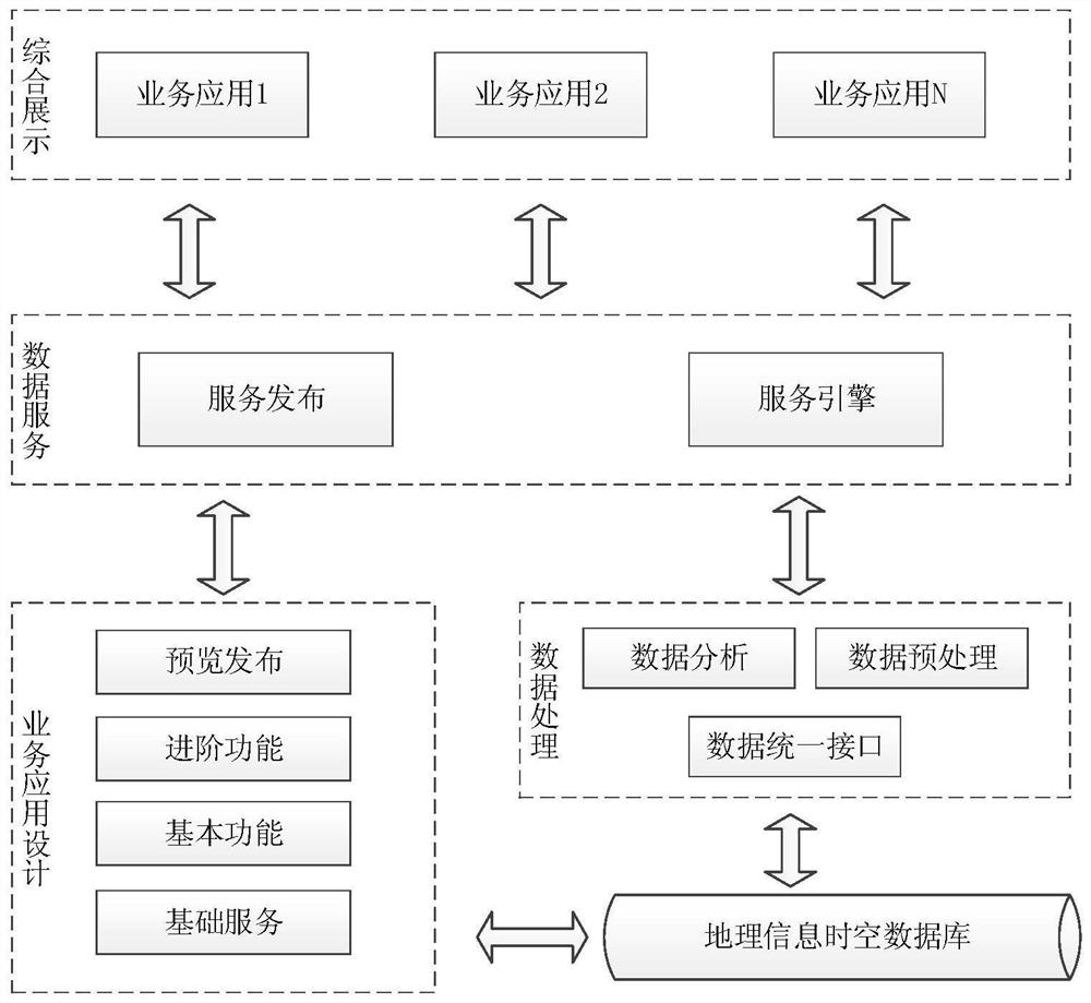
[0034] Such as figure 1 As shown, a system for quickly building geographic information data applications includes geographic information spatiotemporal database, data processing module, data service module, business application design module, and comprehensive display module. Based on the WEB architecture, it can be customized independently on the basis of the general display framework to realize different business application display functions and user interfaces.

[0035] 1. Spatio-temporal database of geographic information

[0036] It is used to store all kinds of original electronic map data based on location information.

[0037] The original electronic map data includes aerial images, satellite images, panoramic images, lidar data, vector maps and three-dimensional models.

[0038] 2. Data processing module

[0039] Preproce...


PUM


Abstract

A system and method for rapidly building geographic information data applications, belonging to the field of geographic information data analysis applications. The present invention designs a general and configurable data application framework, which mainly includes a geographic information spatio-temporal database, a data processing module, a data service module, a business application design module and a comprehensive display module. The present invention divides the various processing and rendering processes required for the application and analysis of geographic information data into independent functional modules one by one, and encapsulates the input and output interfaces according to the data transmission protocol defined by the system. Select basic services, basic functions, and advanced functions, and configure the required application display functions and user interfaces according to business requirements to meet the needs of different businesses and users for data display.

Description

technical field [0001] The invention relates to a system and method for rapidly building geographic information data applications, belonging to the field of geographic information data analysis applications. Background technique [0002] Geographic information data is the basis of many related tasks such as urban planning, environmental protection, land survey, and road construction. From image data acquisition to business application, a series of processing procedures are required, including image correction, image registration, data fusion, and image mosaic. , block cutting, data quality inspection and many other steps. The application display of geographic information data involves factors such as map drawing, data processing, and effect rendering. Usually, the function page is customized according to application requirements. With the development of information technology With the increasing demand for social application of geographic information data, the application of...

Claims


Application Information

Patent Timeline
Patent Type & Authority Patents(China)
IPC IPC(8): G06F16/29G06F16/25G06F16/955
Inventor 黄勇肖让吕利伟蔡玲张男杨智博
Owner 贵州图智信息技术有限公司
Learn More