Unlock instant, AI-driven research and patent intelligence for your innovation.

Sea surface ship on-orbit identification method based on optical remote sensing satellite near-infrared spectrum band

A technology of optical remote sensing and identification method, which is applied in the field of on-orbit identification of sea ships based on the near-infrared spectrum of optical remote sensing satellites. It can solve the problems of high complexity, low resolution, and large noise of radar signals, and achieve computational complexity. The effect of low, clear algorithm structure

Active Publication Date: 2019-07-26
CHANGGUANG SATELLITE TECH CO LTD
View PDF6 Cites 5 Cited by
  • Summary
  • Abstract
  • Description
  • Claims
  • Application Information

AI Technical Summary

Problems solved by technology

Among them, the radar load has the advantages of all-weather and all-weather detection, and is not disturbed by waves and sea surface flares. A variety of ship identification methods for radar images have been developed, such as the research on spaceborne SAR ship and wake detection technology (Zhang Yu et al. , "Remote Sensing Technology and Application", No. 1, 2003, pp. 31-35), but the radar signal is noisy, the resolution is low, and information inversion is required; the optical payload has the advantages of high resolution and high degree of visualization , but it is greatly affected by the weather, and the identification process is more sensitive to sea waves and sea surface flares. In order to improve the ability of optical load detection, researchers have proposed many processing methods, such as saliency, machine learning, deep learning and other methods, but the public Most of the methods have high complexity and are difficult to be directly applied in orbit

Method used


Image

  • Sea surface ship on-orbit identification method based on optical remote sensing satellite near-infrared spectrum band
  • Sea surface ship on-orbit identification method based on optical remote sensing satellite near-infrared spectrum band
  • Sea surface ship on-orbit identification method based on optical remote sensing satellite near-infrared spectrum band

Examples


Embodiment Construction

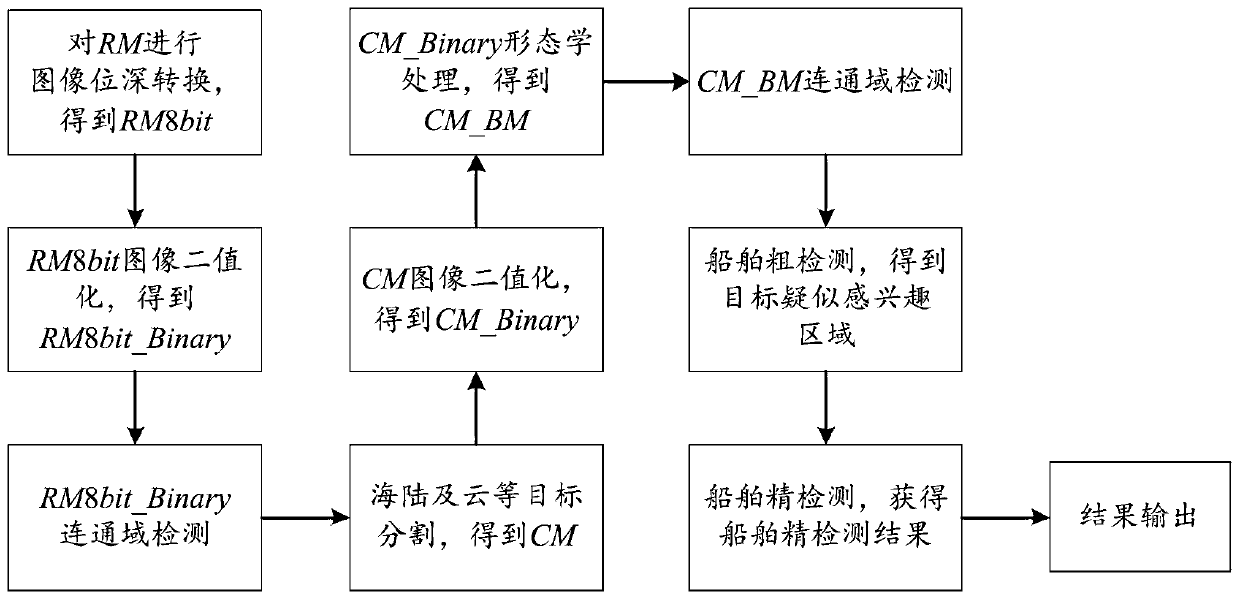
[0028] The identification of ships on the sea can directly serve the fields of maritime trade supervision, shipwreck rescue and national defense security. With its advantages of high resolution and large width, optical remote sensing satellites have become one of the important means of obtaining ship information on the sea surface; when the satellites shoot the sea surface, there are a large amount of invalid data in the images obtained, and the detection and identification of ships in orbit are only stored. Target area images and ship information can greatly improve on-board storage efficiency and improve satellite single-track information acquisition capabilities. In order to avoid interference from sea flares, waves, clouds, reefs, etc., detection methods such as saliency detection, machine learning, and deep learning have been developed in recent years. The detection rate of channel remote sensing images is low, which is difficult to meet the requirements of use. The near...


PUM


Abstract

The invention relates to a sea surface ship on-orbit identification method based on an optical remote sensing satellite near-infrared spectrum band, which comprises the following steps: carrying out bit depth conversion on an obtained near-infrared multispectral remote sensing image to obtain an 8-bit image; performing image binarization processing on the 8bit image to obtain a first binarized image; performing target segmentation on the first binary image subjected to the connected domain detection to obtain a segmented image; performing image binarization processing on the segmented image toobtain a second binarized image; performing morphological processing on the second binary image to obtain a morphologically processed image to be processed; carrying out ship coarse detection on theto-be-processed image subjected to the connected domain detection to obtain a target suspected region of interest; calculating the length, width and confidence coefficient of the target in the targetsuspected region of interest, and obtaining a ship fine detection result according to the length, width and confidence coefficient. According to the invention, high-precision detection and recognitionare realized, the algorithm structure is clear, the calculation complexity is low, and the method is suitable for on-orbit realization.

Description

technical field [0001] The invention relates to the technical field of target detection and recognition, in particular to the technical field of detection and recognition of sea ships, in particular to an on-orbit recognition method for sea ships based on the near-infrared spectrum of optical remote sensing satellites. Background technique [0002] Because satellites in space are not restricted by geographical location, they can observe any point in the world, which is one of the important means of obtaining information on ships on the sea. At this stage, the remote sensing of ships on the sea is mainly divided into two parts: radar load and optical load. Among them, the radar load has the advantages of all-weather and all-weather detection, and is not disturbed by waves and sea surface flares. A variety of ship identification methods for radar images have been developed, such as the research on spaceborne SAR ship and wake detection technology (Zhang Yu et al. , "Remote Se...

Claims


Application Information

Patent Timeline
IPC IPC(8): G06K9/00G06K9/32G06K9/34G06K9/38
CPCG06V20/20G06V10/255G06V10/26G06V10/28
Inventor 于树海贺小军安源
Owner CHANGGUANG SATELLITE TECH CO LTD
Features
  • R&D
  • Intellectual Property
  • Life Sciences
  • Materials
  • Tech Scout
  • Unparalleled Data Quality
  • Higher Quality Content
  • 60% Fewer Hallucinations
Learn More