Farmland portrait and pesticide fertilizer big data analysis method based on satellite remote sensing images

A satellite remote sensing image and data analysis technology, applied in the field of remote sensing technology and geographic information system, can solve the problem of low farmland fine management, achieve the effect of ensuring yield, realizing fine management, and solving chain disconnection

Pending Publication Date: 2019-08-09
国智恒北斗好年景农业科技有限公司
View PDF4 Cites 7 Cited by
  • Summary
  • Abstract
  • Description
  • Claims
  • Application Information

AI Technical Summary

Problems solved by technology

[0003] In order to solve the problem of low fine management of existing farmland, the present invention provides a method of analyzing farmland portraits and fertilizer big data based on satellite remote sensing images with convincing data

Method used


Image

  • Farmland portrait and pesticide fertilizer big data analysis method based on satellite remote sensing images

Examples


Embodiment Construction

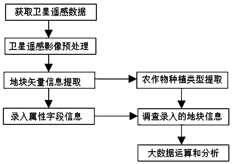
[0031] The core of the present invention is to provide a method for analyzing farmland portraits and fertilizer big data based on satellite remote sensing images.

[0032] Below in conjunction with accompanying drawing, content of the present invention will be further described:

[0033] This program provides a method for analyzing farmland images and fertilizer big data based on satellite remote sensing images, including the following steps;

[0034] 1) Acquisition of satellite remote sensing images: cutting and processing the domestic satellite Gaofen-2 images with a resolution of 0.8 meters within the survey area. The larger the survey area, the more survey targets, the more plots with basically the same growth environment obtained after big data calculation analysis, and the more accurate and reliable the report output by the big data calculation analysis module.

[0035] 2) Preprocessing of satellite images within the study area: the preprocessing process is completed wi...


PUM


Abstract

The invention relates to the technical field of remote sensing technologies and geographic information systems, in particular to a farmland portrait and pesticide fertilizer big data analysis method based on satellite remote sensing images for agricultural big data analysis, which comprises the following steps: 1) acquiring satellite image remote sensing data; 2) preprocessing remote sensing data;3) extracting crop planting types; 4) extracting plot vector information of the satellite image; 5) inputting attribute field information for the plot vector; 6) investigating the input plot attribute field, and 7) performing big data operation and screening analysis on the collected plot information. The farmland portrait and pesticide fertilizer big data analysis method based on the satellite remote sensing image has the advantages of being high in farmland data precision, high in refinement degree and high in data persuasion.

Description

technical field [0001] The invention relates to the technical fields of remote sensing technology and geographic information system, in particular to a method for analyzing agricultural big data based on satellite remote sensing images of farmland portraits and big data of medicine and fertilizer. Background technique [0002] With the development of the times and science and technology, traditional farming methods have basically disappeared, replaced by new farming methods with modern characteristics of industrialization and technology. my country is a large agricultural country. With the rise of science and technology and the advancement of technology, emerging technologies including big data, remote sensing technology, and geographic information systems have been widely used in agriculture, and have the means to increase crop production; more and more Many chemical drugs are sprinkled into the farmland, such as chemical fertilizers, herbicides, etc.; their appearance has g...

Claims


Application Information

Patent Timeline
IPC IPC(8): G06K9/00G06F17/50G06Q50/02
CPCG06Q50/02G06V20/188G06F30/20
Inventor 郑舒心徐博谷俊鹏谢士琴
Owner 国智恒北斗好年景农业科技有限公司
Why Eureka
Try Eureka