Weighted centroid positioning algorithm based on RSSI ranging

A technology of weighted centroid and positioning algorithm, which is applied to services based on location information, services based on specific environments, and positioning. It can solve problems such as ranging errors and inaccurate positioning coordinates, and achieve the effect of improving accuracy and positioning accuracy.

Inactive Publication Date: 2019-08-23
南通云之建智能科技有限公司
5 Cites 3 Cited by

AI-Extracted Technical Summary

Problems solved by technology

[0005] At present, compared with the other three positioning technologies, the RSSI-based positioning method has the advantages of no need to add additional hardware devices, low power consumption, and low cost. However, in the...

Abstract

The invention mainly provides a weighted centroid positioning algorithm based on RSSI ranging. The method comprises the following steps: firstly, sorting distance values between labels to be tested and reference substations, extracting three reference substations with minimum distances, establishing a weighted centroid model, calculating coordinate values of three intersection points according tothe weighted centroid model, and then calculating the coordinate values of the labels to be tested by using a weighted centroid algorithm. According to the weighted centroid positioning algorithm based on RSSI ranging disclosed by the invention, the accuracy of coordinate operation is improved through data selection and weighted value introduction under the condition that the early ranging error is large.

Application Domain

Particular environment based servicesPosition fixation +1

Technology Topic

Weight valueData selection +5

Image

  • Weighted centroid positioning algorithm based on RSSI ranging
  • Weighted centroid positioning algorithm based on RSSI ranging
  • Weighted centroid positioning algorithm based on RSSI ranging

Examples

  • Experimental program(1)

Example Embodiment

[0027] Embodiments of the technical solutions of the present invention will be described in detail below in conjunction with the accompanying drawings. The following examples are only used to illustrate the technical solutions of the present invention more clearly, and therefore are only examples, rather than limiting the protection scope of the present invention.
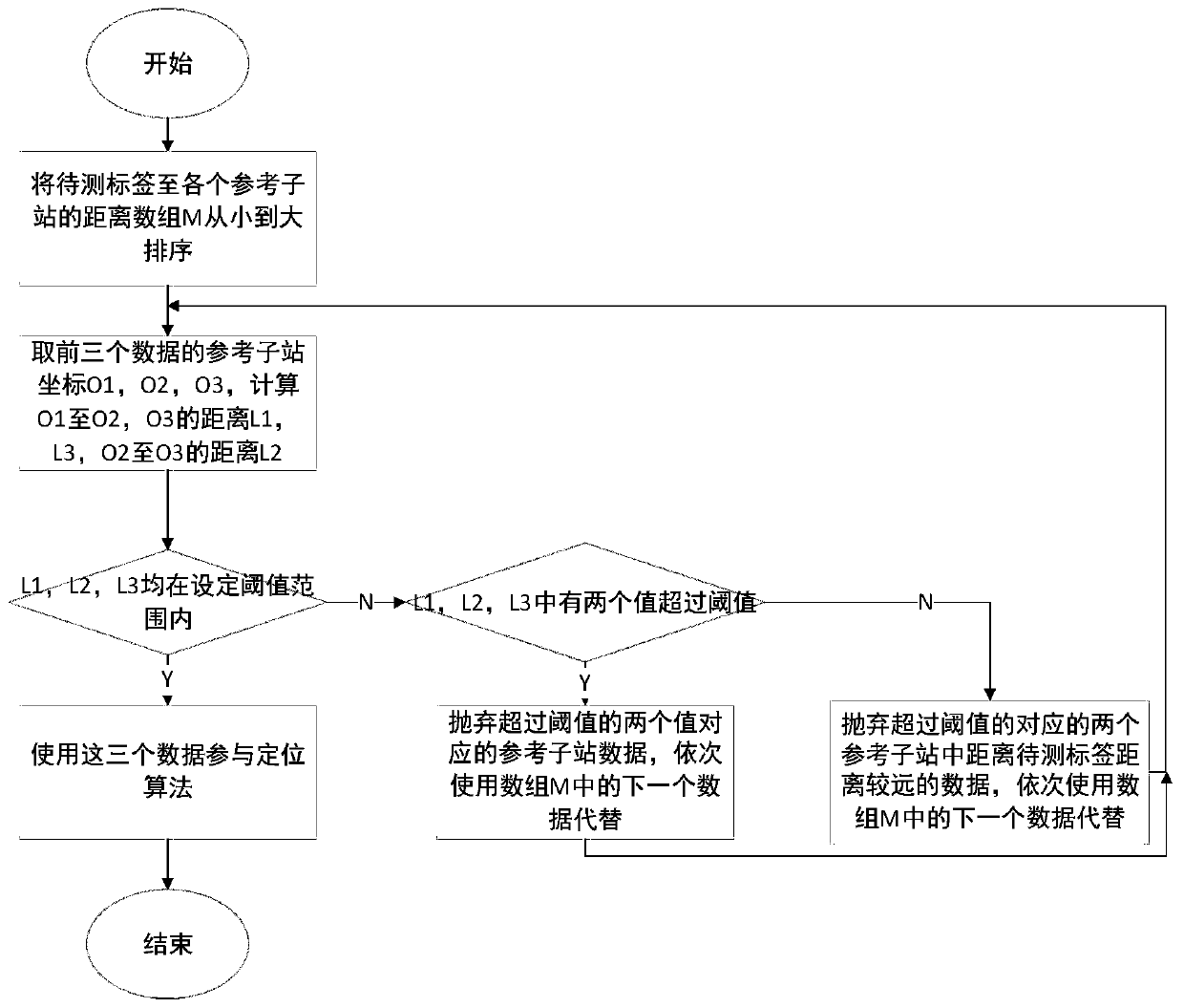
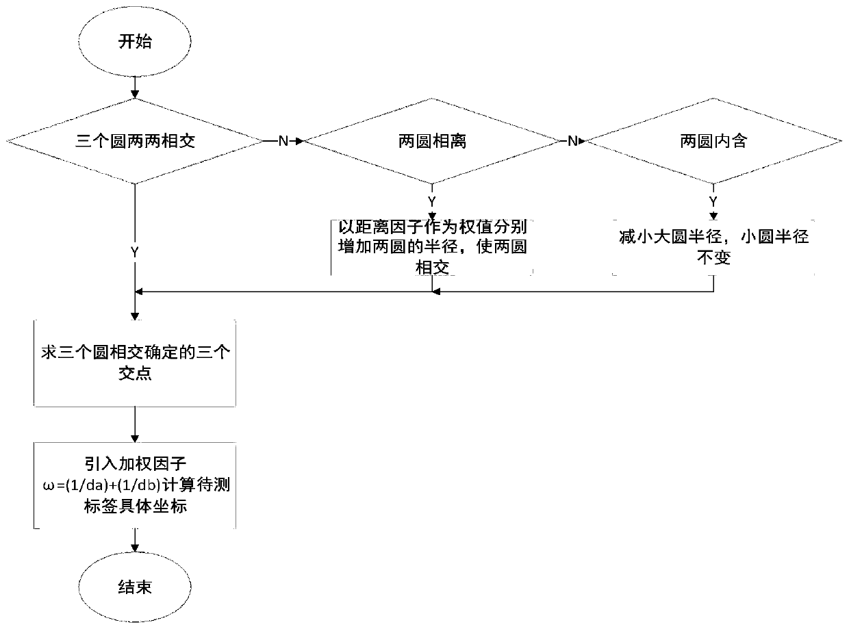
[0028] A weighted centroid positioning algorithm based on RSSI ranging disclosed by the present invention is implemented based on a positioning system. The positioning system includes a server, a base station, a plurality of reference sub-stations and tags to be tested. Calculate the distance between the stations and send it to the server. The server calculates the coordinate value of the label to be tested according to the weighted centroid positioning algorithm combined with the coordinate value of the reference sub-station, such as Figure 1~2 As shown, the specific steps are:
[0029] a. The distance value d between the tag to be tested and each reference sub-station 1 、d 2 … d n Sort in descending order to form a distance group.
[0030] b. Extract the first three distance values ​​d from the sorted distance group 1 、d 2 、d 3 , these three distance values ​​represent the distance between the tag to be tested and the three nearest reference sub-stations, and the coordinate values ​​O of these three reference sub-stations 1 (X 1 , Y 1 ), O 2 (X 2 , Y 2 ), O 3 (X 3 , Y 3 ) Calculate the sub-station distance L between the three reference sub-stations 12 , L 13 , L 23.
[0031] c. Substation spacing L calculated in step b 12 , L 13 , L 23 Compared with the preset threshold m, if the distance between a certain sub-station exceeds the preset threshold, the corresponding sub-station is eliminated, and the fourth distance value d is extracted from the distance group 4 , repeat step b, if none of them exceed the preset threshold, then output the coordinate values ​​O of the three reference sub-stations 1 (X 1 , Y 1 ), O 2 (X 2 , Y 2 ), O 3 (X 3 , Y 3 ) and the distance d between the tag to be tested and the three sub-stations 1 、d 2 、d 3.
[0032] The specific steps of elimination are: the sub-station spacing L 12 , L 13 , L 23 At the same time compared with m, if L 12 and L 13 All greater than m, L 23 is less than m, then remove the reference node O 1 , keep O 2 and O 3 , if only L 12 greater than m, L 13 and L 23 is less than m, then remove the reference node O 1 and O 2 The one that is farther away from the label to be tested, keep the closer one, and keep the reference node O at the same time 3.
[0033] Set the sub-station spacing L 12Compared with m, if it exceeds, remove the reference sub-station O 2 , if it does not exceed, the sub-station distance L 13 Compared with m, if it exceeds, remove the reference sub-station O 3 , if not, the sub-station spacing L 23 Compared with m, if it exceeds, remove the reference sub-station O 3.
[0034] d. Take three reference sub-station coordinates O 1 (X 1 , Y 1 ), O 2 (X 2 , Y 2 ), O 3 (X 3 , Y 3 ) is the origin, and the corresponding distance value d 1 、d 2 、d 3 Draw a circle for the radius, establish a weighted centroid model, and judge the relative position of the three circles. If two circles intersect each other, perform step e. If the two circles are separated, perform step g. If the two circles contain two circles, perform step h.
[0035] In the actual positioning process, due to the interference of noise such as multipath attenuation and obstacles, the signal strength value often fluctuates greatly, which makes the distance value converted from the RSSI value have a large error, resulting in the calculated tag to be tested. The distance value of the reference substation deviates far from the actual distance, so that the three circles in step d cannot meet the requirements of intersecting two by two, and there are also situations where two circles are separated or contained in two circles, which need to be separated.
[0036] e. Reference sub-station O 2 with reference substation O 3 At reference substation O 1 The intersection point inside is A, and its coordinate value is A(X A , Y A ), reference substation O 1 with reference substation O 3 At reference substation O 2 The intersection point inside is B, and its coordinate value is B(X B , Y B ), reference substation O 1 with reference substation O 2 At reference substation O 3 The intersection point within is C, and its coordinate value is C(X C , Y C ), using the coordinate values ​​and radius values ​​of the three reference sub-stations to calculate the coordinate values ​​of the three intersection points, this calculation can refer to the existing calculation methods, and will not be described in detail.
[0037] f. Use the coordinates of the three intersection points combined with the weighted centroid algorithm to obtain the coordinates (X, Y) of the label to be tested, where:
[0038]
[0039]
[0040] Where: ω A is the weighted value of intersection point A, and ω B is the weighted value of intersection point B, and ω C is the weighted value of intersection point C, and
[0041] According to the weighted centroid model, it can be judged that the label to be tested is located in the triangular area formed by the three intersection points ABC. If the label to be tested is exactly located in the centroid of the triangular area, its coordinate value According to this calculation formula, it can be seen that the influence weights of the three vertices of ABC on the centroid are the same. However, in actual situations, the label to be tested is not necessarily located at the centroid. The weights are different, and this application introduces a weighted value as a coefficient to balance the mutual influence for this difference.
[0042] g. When there is a separation between the circles, the principle of distance correction used in the present invention increases the radius of the two circles synchronously so that the circles intersect in pairs to form an overlapping area, and then return to step e to calculate the intersection coordinates Calculate the coordinate value of the label to be tested;
[0043] Using this method ensures that the ratio of the increased radius to the previous radius remains unchanged to reference substation O 1 with reference substation O 2 Taking a circle as an example, the formula for increasing its radius is:
[0044]
[0045] where d is the distance between the centers of the two circles.
[0046] h. When there is an inclusion between the two circles, the present invention reduces the radius of the circle with the larger radius to make it tangent to the circle with the smaller radius to form an intersection point, and then return to step e to calculate the coordinates of the intersection point and calculate the coordinate value of the label to be measured ;
[0047] With reference to substation O 1 with reference substation O 2 Draw a circle as an example, d 1 d 2 , its correction scheme is as follows, d 1 '=d+d 2 , where d is the distance between the centers of the two circles.
[0048] The technical contents and technical features of the present invention have been disclosed above, but those skilled in the art may still make various replacements and modifications based on the disclosure of the present invention without departing from the spirit of the present invention. Therefore, the protection scope of the present invention should not be limited to the embodiments The disclosed content should include various replacements and modifications that do not depart from the present invention, and are covered by the claims of this patent application.

PUM

no PUM

Description & Claims & Application Information

We can also present the details of the Description, Claims and Application information to help users get a comprehensive understanding of the technical details of the patent, such as background art, summary of invention, brief description of drawings, description of embodiments, and other original content. On the other hand, users can also determine the specific scope of protection of the technology through the list of claims; as well as understand the changes in the life cycle of the technology with the presentation of the patent timeline. Login to view more.

Similar technology patents

Classification and recommendation of technical efficacy words

  • High precision
  • High positioning accuracy

Method for forecasting short-term power in wind power station

InactiveCN102102626AHigh precision
Owner:NORTH CHINA ELECTRIC POWER UNIV (BAODING) +1

Numerical control machine tool wear monitoring method

InactiveCN102091972AHigh precisionReal-time monitoring of tool wear
Owner:HUAZHONG UNIV OF SCI & TECH +1

Advertisement recommendation method and apparatus

ActiveCN104965890AHigh precisionPrecise screening
Owner:SHENZHEN TENCENT COMP SYST CO LTD

System and method for detecting high voltage transmission line faults

InactiveCN101813740AIncrease system capacityHigh positioning accuracy
Owner:TIANJIN ZHILIAN HENGXIN ELECTRIC POWER EQUIP CO LTD

Production method of chassis of railway vehicle

ActiveCN102101219AReasonable positioningHigh positioning accuracy
Owner:CRRC NANJING PUZHEN CO LTD

Electronic fence based on real-time geographic position

InactiveCN103186963AGood monitoring and managementHigh positioning accuracy
Owner:TERRA DIGITAL CREATING SCI & TECH BEIJING CO LTD
Why Eureka
Try Eureka