Low-orbit navigation enhancement precision correction data generation and uploading system and method

A data correction and precision technology, applied in the field of navigation enhancement, can solve the problems of reducing system reliability, increasing construction cost, acquiring precise data, etc., and achieving the goal of reducing system complexity, improving system maturity, and reducing construction costs. Effect

Active Publication Date: 2019-08-30
火眼位置数智科技服务有限公司
View PDF13 Cites 16 Cited by
  • Summary
  • Abstract
  • Description
  • Claims
  • Application Information

AI Technical Summary

Problems solved by technology

[0004] The navigation receiver can improve the accuracy of navigation and positioning by receiving GNSS precision orbit and precision clock difference products, and the highest single-point positioning accuracy can reach centimeter level, but the navigation receiver cannot obtain precise data through the Internet in many application scenarios, such as low orbit For the on-board GNSS receivers of all satellites in the navigation augmentation satellite system, to achieve centimeter-level positioning, the GNSS precision orbit products and precision clock products on the ground must be obtained through other communication links. The general system uses low-orbit inter-satellite links In this way, it is injected into one of the satellites through the ground station, and then transmitted to each satellite of the constellation system through the inter-orbit inter-satellite link a

Method used


Image

  • Low-orbit navigation enhancement precision correction data generation and uploading system and method
  • Low-orbit navigation enhancement precision correction data generation and uploading system and method
  • Low-orbit navigation enhancement precision correction data generation and uploading system and method

Examples


Embodiment Construction

[0054] The present invention will be described in detail below in conjunction with the accompanying drawings and specific embodiments. Apparently, the described embodiments are some, not all, embodiments of the present invention. Based on the embodiments of the present invention, all other embodiments obtained by persons of ordinary skill in the art without making creative efforts shall fall within the protection scope of the present invention.

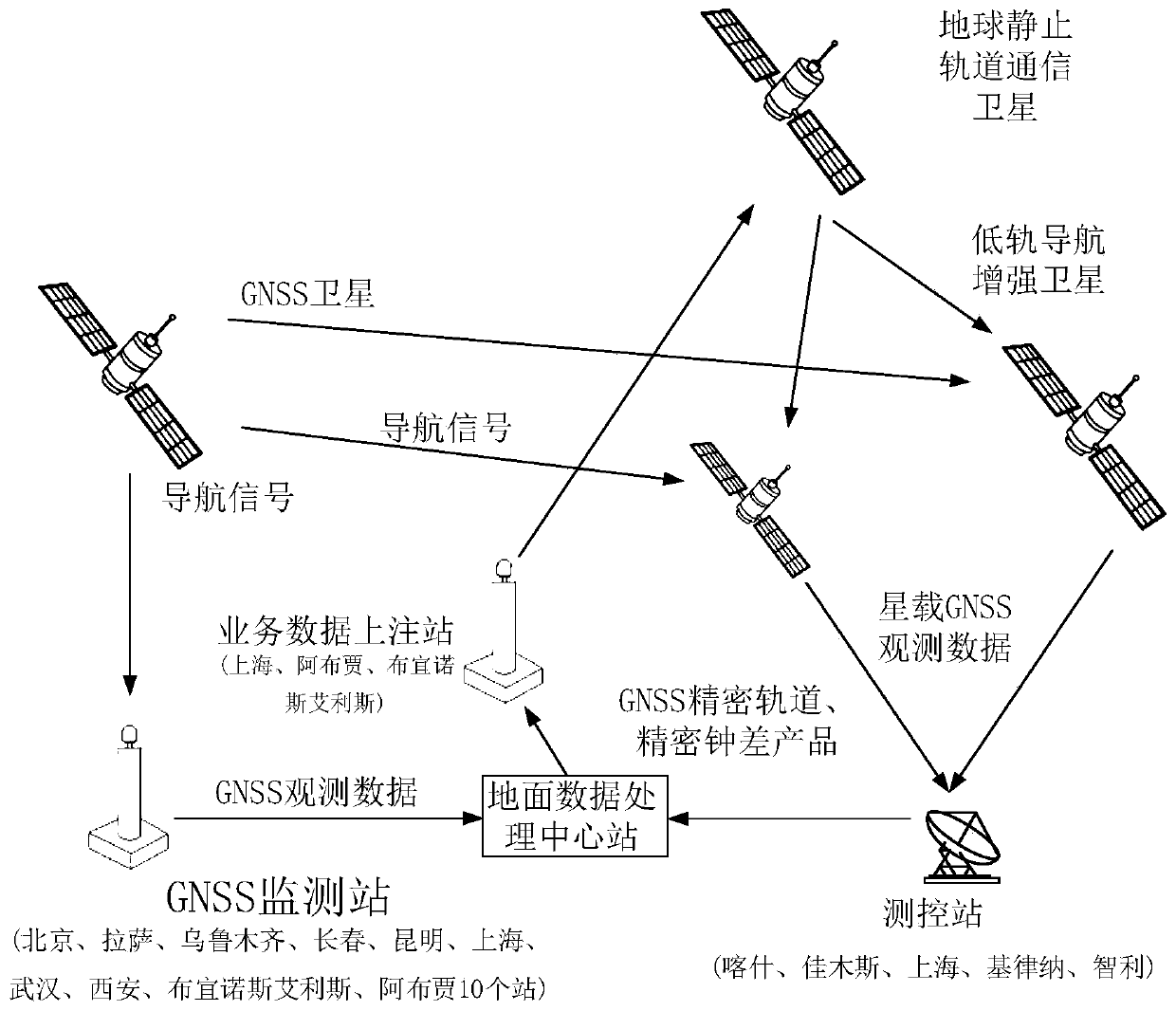
[0055] like figure 1 As shown, the present invention relates to a low-orbit navigation enhanced precision correction data generation and upper note system, which includes GNSS satellites, low-orbit navigation enhanced satellites, three evenly distributed geostationary orbit communication satellites, and GNSS monitoring on the ground station, service data uploading station, ground data processing center station and satellite monitoring and control station. GNSS satellites are used to send navigation signals to LEO navigation augmenta...


PUM


Abstract

The invention relates to a low-orbit navigation enhancement precision correction data generation and uploading system and method. A ground data processing central station combines monitoring data acquired by a GNSS (Global Navigation Satellite System) monitoring station and low-orbit satellite monitoring data acquired by a satellite measurement and control station for processing to generate SSR (State Space Representation) data; the generated SSR data is evaluated and then transmitted to three service data uploading stations, the three service data uploading stations respectively transmit theSSR data to three geostationary orbit communication satellites as high elliptical orbit satellites through an uploading channel, a low-orbit navigation enhancement satellite receives the SSR data broadcasted by the geostationary orbit communication satellites, and processes the uploaded SSR data by adopting a navigation enhancement load t generate enhanced navigation signals so as to complete high-precision orbit determination and low-orbit navigation enhancement information generation. Compared to the prior art, the method for generating and uploading the SSR correction data of the navigationsystem required by the low-orbit navigation enhancement system is achieved without depending on low-orbit inter-satellite links, so that the complexity of the low-orbit system is reduced, the reliability of the low-orbit constellation system is improved, and the service life of the low-orbit constellation system is prolonged.

Description

technical field [0001] The invention relates to the technical field of navigation enhancement, in particular to a system and method for generating and adding precision correction data for low-orbit navigation enhancement. Background technique [0002] Global Navigation Satellite System (GNSS), especially the GPS system in the United States, the GLONASS system in Russia, the Galileo system in Europe and the Beidou system in China, have been widely used around the world to provide navigation and positioning services for users in various fields. However, with the promotion of applications, the current high-precision surveying and mapping, precision agriculture, transportation and logistics, aviation management and other fields have higher and higher requirements for navigation and positioning accuracy, availability, and integrity. The traditional GNSS system can no longer meet the needs. [0003] In the current navigation field, the IGS organization uses the observation data of...

Claims


Application Information

Patent Timeline
IPC IPC(8): G01S19/01G01S19/07G01S19/40H04B7/185
CPCG01S19/01G01S19/07G01S19/40H04B7/1851Y02D30/70
Inventor 张悦江金凤
Owner 火眼位置数智科技服务有限公司
Why Eureka
Try Eureka