Loess plateau terraced field extraction method based on remote sensing images and DEM

A technology of remote sensing images and the Loess Plateau, which is applied in image enhancement, image analysis, image data processing, etc., can solve problems such as not being able to be used in a large range, easily forming broken patterns, and affecting the accuracy of terrace extraction, so as to improve the extraction Efficiency and the effect of reducing manual workload

Active Publication Date: 2019-09-06
南京泛在地理信息产业研究院有限公司 +1
View PDF4 Cites 5 Cited by
  • Summary
  • Abstract
  • Description
  • Claims
  • Application Information

AI Technical Summary

Problems solved by technology

[0003] The terraces are extracted based on remote sensing images. The effect of the terraces extracted by the technology of gray-level co-occurrence matrix and Fourier transform is not ideal, and the recognition accuracy cannot be guaranteed. range of use
Object-oriented technology has been developed in recent years. By anal...

Method used


Image

  • Loess plateau terraced field extraction method based on remote sensing images and DEM
  • Loess plateau terraced field extraction method based on remote sensing images and DEM
  • Loess plateau terraced field extraction method based on remote sensing images and DEM

Examples


Embodiment Construction

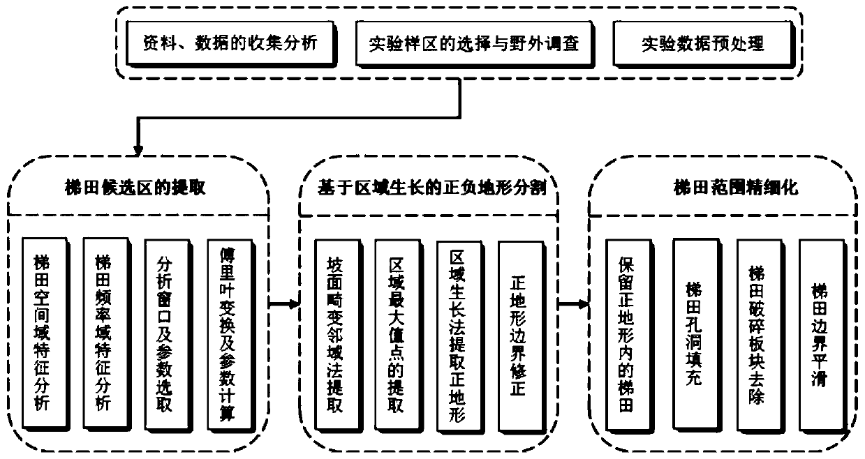
[0044] See figure 1 , which shows a flowchart of a method for extracting loess plateau terraces based on remote sensing images and DEM.

[0045] The technical solution of the present invention will be described in further detail below in conjunction with the accompanying drawings and embodiments.

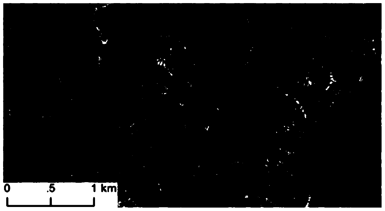
[0046] The sample area in this example is the middle and lower reaches of the Wuding River in Suide County, Shaanxi Province. ″E, the sample area has vertical and horizontal gullies, extremely severe soil erosion, and widely distributed terraced fields, which belong to loess hilly hills and gullies. There are many terraced fields in this sample area, with obvious characteristics of terraced fields and clear ridges of terraced fields, including various typical terraced fields on the Loess Plateau (seedless terraced fields, seeded terraced fields, and multi-nucleated terraced fields). The experimental data are remote sensing images with a resolution of 0.5m and DEM data with a resol...


PUM


Abstract

The invention provides a loess plateau terraced field extraction method based on remote sensing images and DEM. The loess plateau terraced field extraction method includes the steps: firstly, analyzing a remote sensing image to obtain the characteristics of a terraced field in a space domain and a frequency domain; proposing parameters capable of reflecting the characteristics of the remote sensing image terraced field, and determining an appropriate parameter threshold value for extracting a remote sensing image terraced field candidate region; extracting the terraced field candidate region by utilizing Fourier transform and combining image characteristic parameters according to the gray scale change rule of the terraced field image; extracting a normal terrain region by using a region growth method based on the DEM; obtaining a terrace region located on the normal terrain through the intersection of the normal terrain area and the terrace candidate region; and finally refining the terrace range through hole filling, broken pattern spot removal and boundary smooth image processing operation to obtain the final terrace range. The loess plateau terraced field extraction method basedon remote sensing images and DEM has the advantages of being simple in operation method, high in universality, high in efficiency, high in extraction precision and the like, and can be applied to loess plateau water and soil detection and land utilization investigation work.

Description

technical field [0001] The invention belongs to water and soil conservation and land resources monitoring technology, and relates to a method for extracting terraced fields, in particular to a method for extracting terraced fields in the Loess Plateau based on remote sensing images and DEM. Background technique [0002] Terraced fields are a typical man-made landform, which is a stepped farmland built along the contour line along the hillside. It has a long history in China. Terraces are an important soil and water conservation measure in the Loess Plateau. Terraced fields have changed the land use type and soil erosion mode, and have the functions of water conservation, water storage and production increase. In recent years, the state has intensified the comprehensive control of soil and water loss on the Loess Plateau, and implemented a large number of soil and water conservation projects such as "slopes to terraces", and the area of ​​terraced fields has continued to inc...

Claims


Application Information

Patent Timeline
IPC IPC(8): G06T7/11G06T7/187G06T5/10G06T7/62
CPCG06T7/11G06T5/10G06T7/187G06T7/62G06T2207/10032G06T2207/20192G06T2207/20056G06T2207/30188Y02A40/28
Inventor 李发源罗兰花杨雪戴子扬刘玮
Owner 南京泛在地理信息产业研究院有限公司
Why Eureka
Try Eureka