Supercharge Your Innovation With Domain-Expert AI Agents!

Ground-air cooperative visual navigation method and device based on improved graph optimization SLAM

A visual navigation and graph optimization technology, applied in the field of navigation, can solve problems such as system instability, low navigation efficiency, and algorithm complexity, and achieve the effects of solving channel blockage problems, speeding up the calculation speed, and reducing time

Pending Publication Date: 2019-09-20
NANJING UNIV OF AERONAUTICS & ASTRONAUTICS
View PDF0 Cites 6 Cited by
  • Summary
  • Abstract
  • Description
  • Claims
  • Application Information

AI Technical Summary

Problems solved by technology

[0005] The present invention provides a ground-air collaborative visual navigation method and device based on improved graph optimization SLAM. By introducing the probability calculation theory of graph optimization, graph optimization can greatly reduce the need for EKF prediction in the process of EKF prediction without abandoning the basic calculation framework. Calculating the dimension of the matrix makes the matrix sparse, which solves the problem of algorithm complexity caused by the dimension of the matrix, and solves the problem of low navigation efficiency and unstable system operation in the face of multi-agent placement scenarios in the prior art And other issues

Method used


Image

  • Ground-air cooperative visual navigation method and device based on improved graph optimization SLAM
  • Ground-air cooperative visual navigation method and device based on improved graph optimization SLAM
  • Ground-air cooperative visual navigation method and device based on improved graph optimization SLAM

Examples


Embodiment Construction

[0028] The present invention is described in detail below in conjunction with accompanying drawing and specific embodiment:

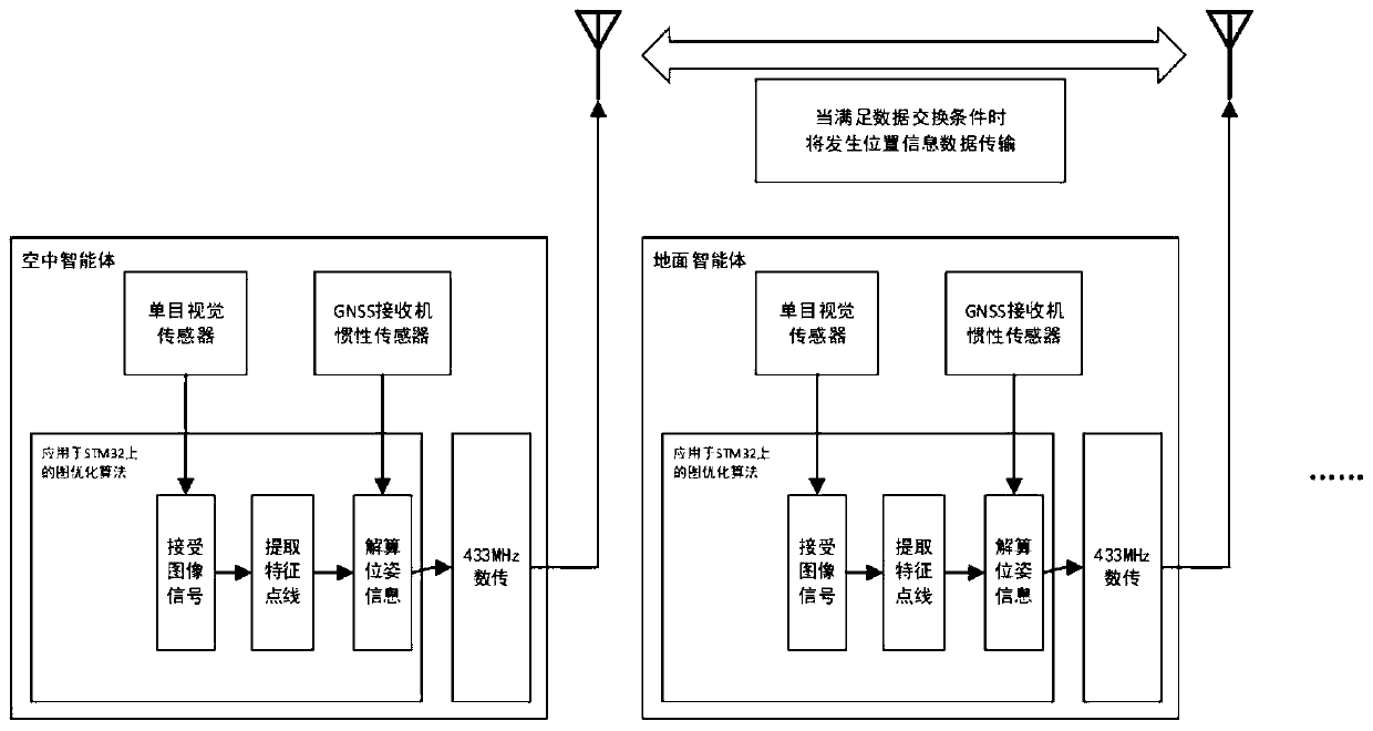
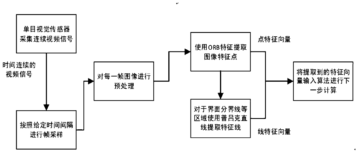
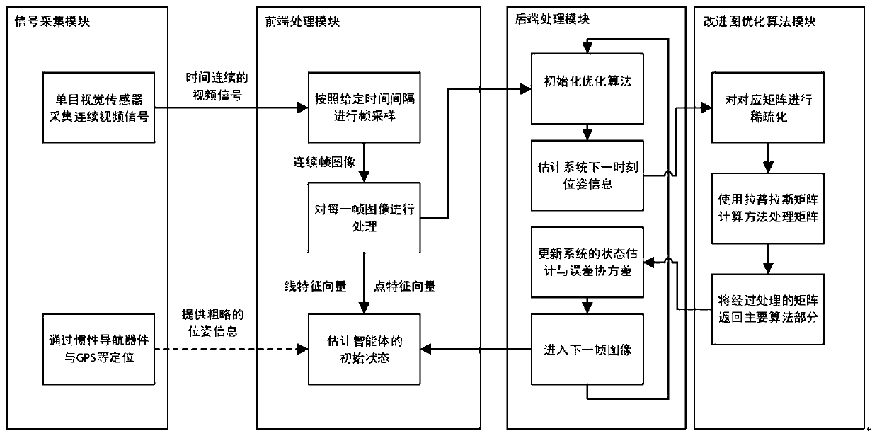
[0029] Such as image 3 As shown, a ground-air collaborative visual navigation device based on improved graph optimization SLAM includes: a signal acquisition module, a front-end processing module, a back-end processing module, and an information communication module; the signal acquisition module includes a monocular vision sensor; the The front-end processing module includes a signal processing system and data transmission; the back-end processing module includes a data computing system; the information communication module includes a data transmission module and an image transmission module; the signal acquisition module transmits the video signal to the The front-end processing module performs pre-processing, and after obtaining the key frame information and feature point information, it is sent to the back-end processing module, and the back-end proc...


PUM


Abstract

The invention discloses a ground-air cooperative visual navigation method and a ground-air cooperative visual navigation device based on improved graph optimization SLAM, which belong to the technical field of navigation. The ground-air cooperative visual navigation device combines sensors with power structures to form intelligent agents in the air and on the ground respectively, wherein each intelligent agent carries the ground-air cooperative visual navigation method based on improved graph optimization SLAM designed in the invention. The ground-air cooperative visual navigation method adopts four modules, wherein a signal acquisition module is used for acquiring position signals and visual signals in a positional environment; a front-end processing module is used for processing the acquired information and converting the various signals into a matrix; a back-end processing module uses the matrix provided by the front-end processing module to perform position estimation and state update; and an improved graph optimization algorithm module is used for speeding up a computation speed of the back-end processing module and reducing the computation pressure of the back-end processing module. By applying the ground-air cooperative visual navigation method, a multi-agent system placed in an unknown environment is subjected to optimization of a positioning navigation system, the positioning precision of the positioning navigation system is improved, the positioning speed is accelerated, and the computation complexity is reduced. The ground-air cooperative visual navigation method and the ground-air cooperative visual navigation device solve the problems of low positioning precision, slow positioning, large error, heavy computation load and the like facing the unknown environment in the prior art.

Description

technical field [0001] The invention belongs to the technical field of navigation, and in particular relates to a ground-air collaborative visual navigation method and device based on improved graph optimization SLAM. Background technique [0002] Visual navigation system has become a popular research field in navigation research in recent years. Since the introduction of Instant Localization and Mapping (SLAM) in 1986, it has developed rapidly. And this technology is more used in intelligent unmanned devices such as drones and unmanned vehicles. When a mobile robot enters an unfamiliar environment, it needs to construct an environmental map through its own sensors, and at the same time determine its own position in the map. Because the camera has excellent characteristics such as small size, light weight, and low price, and the camera can obtain two-dimensional information in the scene, and obtain pose information and motion state information through corresponding algorit...

Claims


Application Information

Patent Timeline
IPC IPC(8): G01S19/42G01C21/16G01S11/12G06T7/70
CPCG01S19/42G01C21/165G01S11/12G06T7/70G06T2207/10016G06T2207/20164
Inventor 王晓龙刘海颖冯建鑫徐子牟王景琪陈捷
Owner NANJING UNIV OF AERONAUTICS & ASTRONAUTICS
Features
  • R&D
  • Intellectual Property
  • Life Sciences
  • Materials
  • Tech Scout
  • Unparalleled Data Quality
  • Higher Quality Content
  • 60% Fewer Hallucinations
Learn More