Optical satellite remote sensing image cloud detection method

A remote sensing image and optical satellite technology, applied in the field of optical satellite remote sensing image processing, can solve the problems of unable to meet the time limit requirements of the cloud detection system, laborious, easy false detection, etc., and achieve the effect of improving the efficiency of cloud detection

Active Publication Date: 2019-09-27
SUZHOU ZHONGKE IMAGE SKY REMOTE SENSING TECH CO LTD
View PDF5 Cites 13 Cited by
  • Summary
  • Abstract
  • Description
  • Claims
  • Application Information

AI Technical Summary

Problems solved by technology

Among them, the physical threshold method analyzes the spectral characteristics of the cloud area, and uses different band threshold combinations to segment the cloud area. Although this method is relatively simple, it is difficult to distinguish the highlight object from the cloud, and it is easy to cause leakage in the thin cloud area. detection; the method based on spatial characteristics utilizes the characteristics of spatial variation of image spectral brightness values, and uses texture feature values ​​and spectral changes to segment cloud areas. Relatively complex; the pattern recognition method extracts image features and uses a large amount of manually labeled data for training. The amount of data is large, time-consuming and laborious, and cannot meet the time limit requirements of the cloud detection system
In addition, there is also the use of multi-period data in the same target area at different times for change monitoring, and cloud extraction based on the results of change monitoring. Although this method has high precision, it has high data requirements, and the image needs to have accurate geographic location information. or matching point information

Method used


Image

  • Optical satellite remote sensing image cloud detection method
  • Optical satellite remote sensing image cloud detection method
  • Optical satellite remote sensing image cloud detection method

Examples


Embodiment Construction

[0055] The technical solutions of the embodiments of the present invention will be clearly and completely described below in conjunction with the accompanying drawings of the present invention.

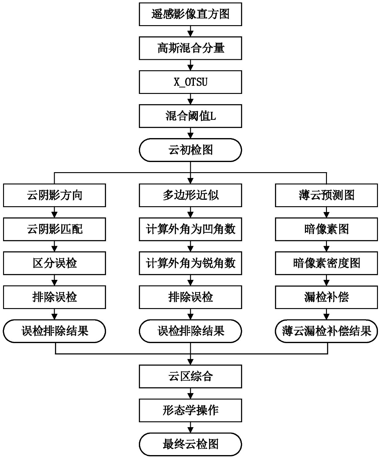
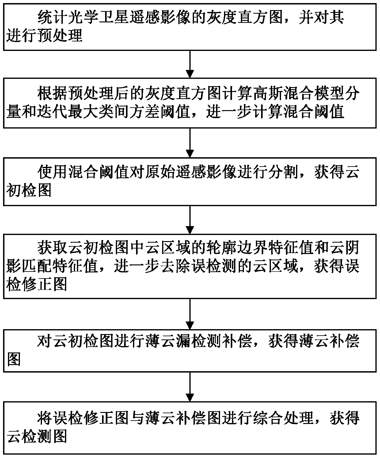
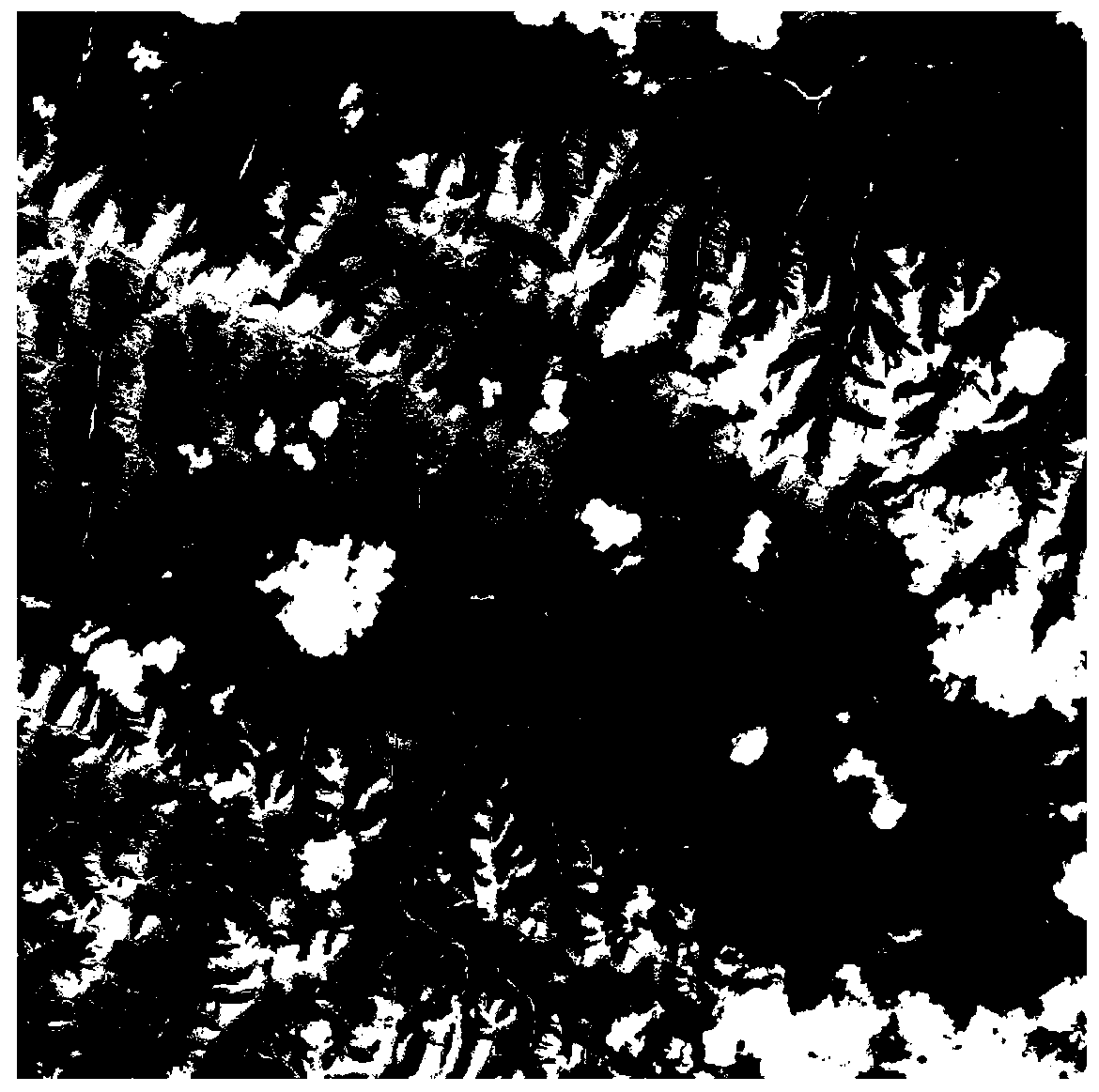
[0056] A method for cloud detection of optical satellite remote sensing images disclosed by the present invention can quickly and accurately detect cloud areas in remote sensing images without the participation of manual or other auxiliary data, and remove falsely detected clouds in the process of detecting cloud areas. area, and compensate the missing thin cloud area, and finally obtain an accurate cloud detection map, which is suitable for panchromatic remote sensing images and multispectral remote sensing images.

[0057] combine figure 1 and figure 2 As shown, it is a kind of optical satellite remote sensing image cloud detection method disclosed by the present invention, comprising the following steps:

[0058] Step S100, count the gray histogram of the optical satellite remot...


PUM


Abstract

The invention discloses an optical satellite remote sensing image cloud detection method. The method comprises the steps of counting a remote sensing image gray histogram and preprocessing the remote sensing image gray histogram; calculating a Gaussian mixture model component and an iteration maximum between-class variance threshold value according to the gray histogram, and further calculating a mixture threshold value; segmenting the remote sensing image by using the mixed threshold to obtain a cloud initial detection image; obtaining a contour boundary characteristic value and a cloud shadow matching characteristic value of a cloud area in the cloud initial inspection image, further removing the cloud area which is mistakenly detected, and obtaining a mistakenly overhauled positive image; performing missing detection thin cloud compensation on the cloud initial detection image to obtain a thin cloud compensation image; and carrying out comprehensive processing on the false overhaul positive image and the thin cloud compensation image to obtain a final cloud detection image. According to the method, the cloud area can be rapidly and accurately detected without manual or other auxiliary data participation, the cloud area which is mistakenly detected is removed in the detection process, the thin cloud area which is missed is compensated for, the cloud detection precision is improved, and the method is suitable for panchromatic remote sensing images and multispectral remote sensing images.

Description

technical field [0001] The invention relates to the technical field of optical satellite remote sensing image processing, in particular to a cloud detection method of optical satellite remote sensing image. Background technique [0002] Optical satellite remote sensing images have a wide range of applications, such as navigation and positioning, environmental protection, and resource utilization, providing effective data protection for comprehensive observations of land, atmosphere, and ocean. Optical satellite sensors are susceptible to many factors during the imaging process, especially cloud cover. More than 50% of the earth's surface is covered by clouds, and remote sensing satellite images are shot above the clouds, resulting in a large number of cloud areas covered in remote sensing images, resulting in the loss of effective pixels of ground objects, which greatly reduces the quality of remote sensing images. In order to make the remote sensing image meet the requirem...

Claims


Application Information

Patent Timeline
Patent Type & Authority Applications(China)
IPC IPC(8): G06K9/00G06K9/34G06K9/46G06K9/62
CPCG06V20/13G06V10/267G06V10/56G06V10/758G06F18/23213Y02A90/10
Inventor 闫小明胡旭东尹烁姚燕胡晓东
Owner SUZHOU ZHONGKE IMAGE SKY REMOTE SENSING TECH CO LTD
Why Eureka
Try Eureka