Field geological three-dimensional comprehensive information platform and data integration and visualization method thereof

A technology that integrates information and geology, applied in the field of virtual reality and field practice teaching, can solve the problems of large impact of landslide thrust, ignoring the elastic-plastic constitutive characteristics of soil, and ignoring the geometric shape of the slope, so as to achieve simple operation and perfect teaching. Methods and means, the effect of good field demonstration teaching aid and research significance

Inactive Publication Date: 2019-09-27
CHINA UNIV OF GEOSCIENCES (BEIJING)
View PDF3 Cites 7 Cited by
  • Summary
  • Abstract
  • Description
  • Claims
  • Application Information

AI Technical Summary

Problems solved by technology

[0005] Aiming at the defects of the prior art, the present invention provides a field geological three-dimensional comprehensive information platform and its data integration and visualization method, which solves the problem that the existing transfer coefficient method ignores the elastic-plastic constitutive characteristics of the soil, does not consider the geometry of the slope, The defect that the change of the inclination angle of the sliding surface has too much influence on the thrust of the landslide

Method used


Image

  • Field geological three-dimensional comprehensive information platform and data integration and visualization method thereof
  • Field geological three-dimensional comprehensive information platform and data integration and visualization method thereof
  • Field geological three-dimensional comprehensive information platform and data integration and visualization method thereof

Examples


Embodiment approach

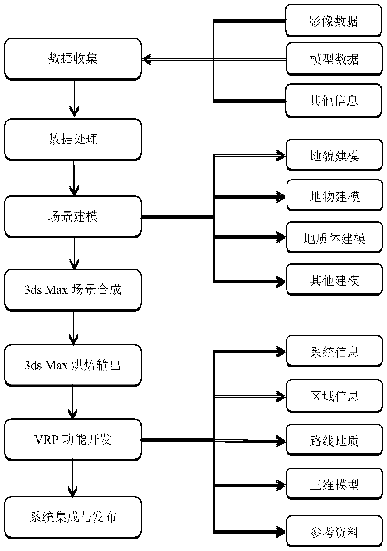
[0047] 1. Technical route

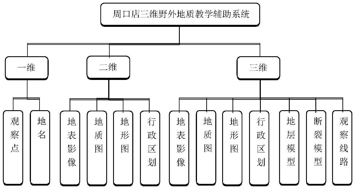
[0048] On the basis of fully studying the characteristics and requirements of Zhoukoudian field geological practice, this embodiment proposes a method system for the construction of a comprehensive information platform for field geological practice in "Digital Zhoukoudian". The method system is to comprehensively utilize the integrated three-dimensional data acquisition and processing means of space, air and ground, geological body modeling technology, multi-source data integration and dual 3D visualization theory to create a three-dimensional field geological teaching auxiliary system in Zhoukoudian.

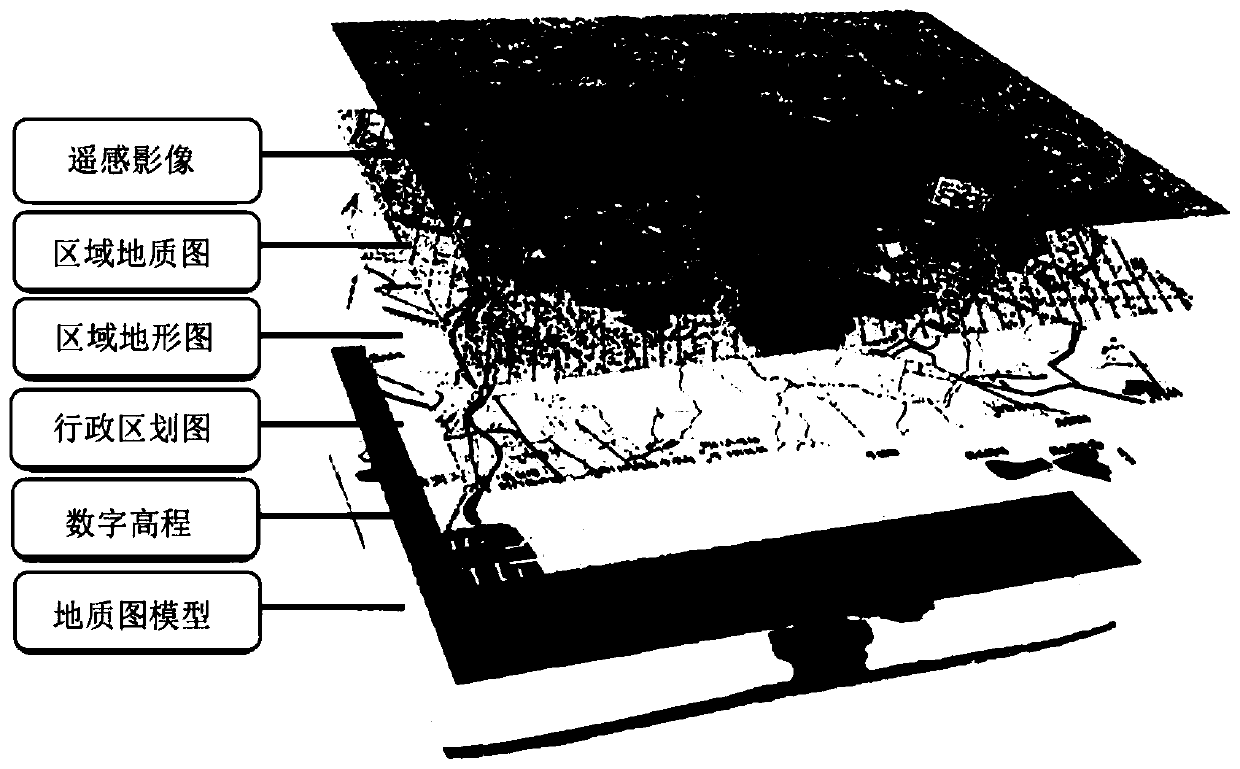
[0049] The integrated three-dimensional data acquisition and processing system of sky, air and ground mainly refers to the use of multi-platforms, multi-sensors, and multi-methods to collect and acquire ultra-high-precision remote sensing orthophotos, digital elevations, geological maps, and topographic maps of the Zhoukoudian practice area And admin...


PUM


Abstract

The invention discloses a field geological three-dimensional comprehensive information platform and a data integration and visualization method thereof. The field geological three-dimensional comprehensive information platform comprises a browsing query and query result output module which realizes two-dimensional and three-dimensional comprehensive visualization browsing and model data query and display. A comprehensive geological information query and result output module comprises comprehensive superposition display of all stratum models, construction models, rock mass models, exploration lines and exploration line sections; a resource-environment information query, display and analysis module is used for realizing information query, display and analysis on fault wrinkles and the like in the practice area. And the field route selection module is used for providing coordinate information of each route and observation points. And the section cutting function and formation section display module is used for acquiring topographic data and assisting students to complete research of the disaster geology module. The method is simple to operate and high in interactivity, does not need network support, integrates practice data, and has a visualization function.

Description

technical field [0001] The invention relates to the field of virtual reality technology, computer technology, GIS remote sensing technology field and field practice teaching field. Specifically, it includes an integrated three-dimensional data acquisition and processing of sky, air and ground, three-dimensional geological modeling technology and virtual reality technology. Background technique [0002] In recent years, in order to adapt to the trend of integration, modernization and visualization of geological work, based on the vigorous development of virtual reality technology, computer technology, network technology and geographic information technology, how to effectively use computers to provide assistance for field geological teaching has become a major issue for the majority of geologists. Based on the development of these technologies, the computer virtual teaching system has emerged as the times require, and has become a powerful tool for field geological teaching. ...

Claims


Application Information

Patent Timeline
Patent Type & Authority Applications(China)
IPC IPC(8): G06T17/05G06T19/00G06F16/54G06F16/55G06F16/587
CPCG06F16/54G06F16/55G06F16/587G06T17/05G06T19/006G06T2200/04
Inventor 陈建平田毅向杰胡桥李诗邱俊秀郑彦威于萍萍
Owner CHINA UNIV OF GEOSCIENCES (BEIJING)
Why Eureka
Try Eureka