
Monitoring method of cloud base height based on FY-4 satellite and ground-based millimeter-wave radar

A technology of millimeter-wave radar and cloud base height, applied in character and pattern recognition, machine learning, instruments, etc., can solve problems such as monitoring result errors, achieve the effects of improving accuracy, increasing range, and reducing errors

Active Publication Date: 2021-03-26
NAT UNIV OF DEFENSE TECH
View PDF6 Cites 0 Cited by
  • Summary
  • Abstract
  • Description
  • Claims
  • Application Information

AI Technical Summary

Problems solved by technology

However, in the actual operation process, due to the use of many empirical formulas, there are large errors in the monitoring results

Method used


Image

  • Monitoring method of cloud base height based on FY-4 satellite and ground-based millimeter-wave radar

Examples


Embodiment

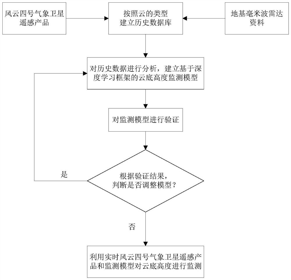
[0046] combine figure 1 , the present invention is based on the cloud base height monitoring method of Fengyun No. 4 satellite and ground-based millimeter-wave radar, comprising the following steps:

[0047] Step 1. According to the cloud base height monitored by the ground-based millimeter-wave radar, the clouds are divided into high clouds (the height of the cloud base monitored by the ground-based millimeter-wave radar is greater than 6000m), medium clouds (the height of the cloud base monitored by the ground-based millimeter-wave radar is greater than 2500m and less than 6000m) ) and low clouds (the height of the cloud base monitored by the ground-based millimeter-wave radar is less than 2500m), and they are marked as 1, 2, and 3 in turn as the labels for model training. According to the monitoring time, monitoring range and cloud type obtained by the ground-based millimeter-wave radar, find the corresponding Fengyun-4 meteorological satellite remote sensing products (incl...


PUM


Abstract

The present invention disclosed a height monitoring method based on the cloud bottom of Fengyun No. 4 and the foundation millimeter wave radar.This method is: the monitoring results of the base of the base millimeter wave radar divide the clouds into different types. Based on this, organize Fengyun No. 4 meteorological satellite remote sensing product and foundation millimeter wave radar data to form a historical database;The accumulated neural network analyzes historical data, and uses the monitoring results of the ground base millimeter wave radar to correct the monitoring results of Fengyun No. 4 meteorological satellite, and establish a highly -based cloud -based high -level monitoring model; use historical data to verify the monitoring model, determine the results according to the resultsWhether to adjust the model; use the real -time Fengyun 4 meteorological satellite remote sensing product and the final determined cloud underground monitoring model to monitor the height of the cloud underground.The invention has high accuracy, small errors, and wide monitoring scope of the height of the cloud underground, which can be used to develop height products of satellite cloud underground.

Description

technical field [0001] The invention belongs to the technical field of atmospheric detection and remote sensing, in particular to a cloud base height monitoring method based on Fengyun-4 satellite and ground-based millimeter-wave radar. Background technique [0002] Cloud base height is an important physical parameter of clouds, which is closely related to the development and changes of clouds. In modern social activities, the height of the cloud base has a major impact. It determines whether the plane can take off and land normally, how to choose the flight route, and even the practical application of weapons and equipment. Therefore, it is particularly important to accurately monitor the cloud base height. [0003] At present, the cloud base height is mainly monitored by radar. The radar sends signals to the cloud layer, and when the signal propagates in the atmosphere, it interacts with the cloud layer, and the echo signal will produce corresponding changes. By analyzin...

Claims


Application Information

Patent Timeline
Patent Type & Authority Patents(China)
IPC IPC(8): G06K9/62G06N3/04G06N20/00
CPCG06N20/00G06N3/045G06F18/214
Inventor 余茁夫胡雄谭仲辉胡申森严卫
Owner NAT UNIV OF DEFENSE TECH
Learn More