Supercharge Your Innovation With Domain-Expert AI Agents!

Method and system for identifying and counting fruit trees by utilizing unmanned aerial vehicle images

A technology for drones and fruit trees, which is applied in image data processing, character and pattern recognition, calculation, etc. It can solve the problems of identifying fruit tree errors, calculating vegetation height, and being unable to use drone data, etc., so as to improve accuracy and achieve better results. The effect of recognizing the effect

Active Publication Date: 2019-12-20
INST OF AGRI RESOURCES & REGIONAL PLANNING CHINESE ACADEMY OF AGRI SCI
View PDF12 Cites 5 Cited by
  • Summary
  • Abstract
  • Description
  • Claims
  • Application Information

AI Technical Summary

Problems solved by technology

Ziliani et al. used the UAV digital surface model in the non-cultivation period as the base data, and used the UAV digital surface model acquired during the vegetation growth period to make a difference with the base data to obtain the vegetation height, but this method needs to be obtained in the non-cultivation period. UAV digital surface model, can not use a single UAV data to calculate vegetation height
[0006] The existing technology is to use orthophotos to identify fruit trees through the diameter range of the fruit tree canopy on a two-dimensional scale, but this method will cause errors in identifying fruit trees by misidentifying other tree species and grass within the diameter range of the canopy

Method used


Image

  • Method and system for identifying and counting fruit trees by utilizing unmanned aerial vehicle images
  • Method and system for identifying and counting fruit trees by utilizing unmanned aerial vehicle images
  • Method and system for identifying and counting fruit trees by utilizing unmanned aerial vehicle images

Examples


Embodiment Construction

[0025] Embodiments of the present invention are described below with reference to the drawings, in which like parts are denoted by like reference numerals. In the case of no conflict, the following embodiments and the technical features in the embodiments can be combined with each other.

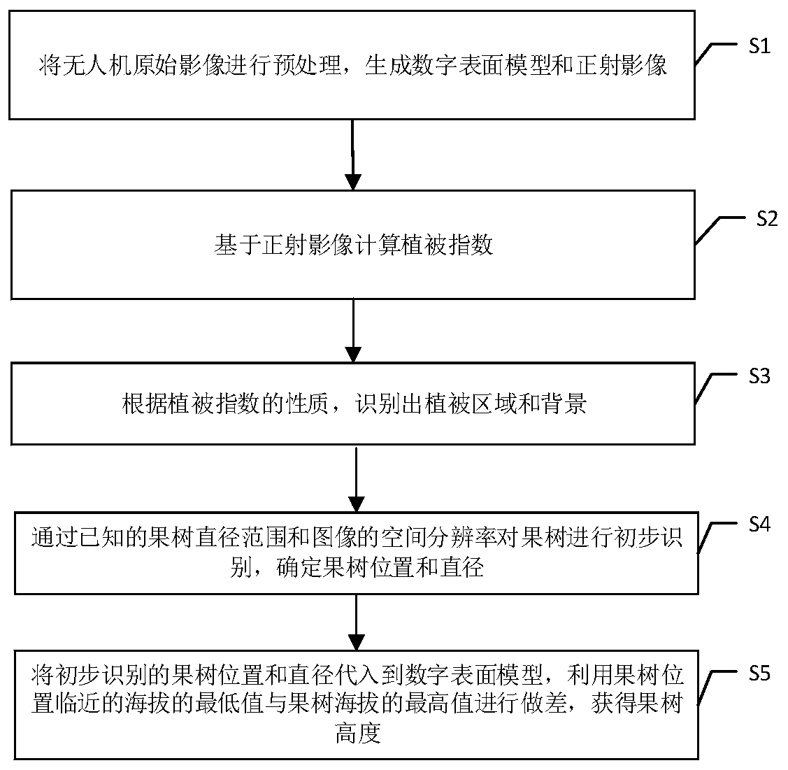
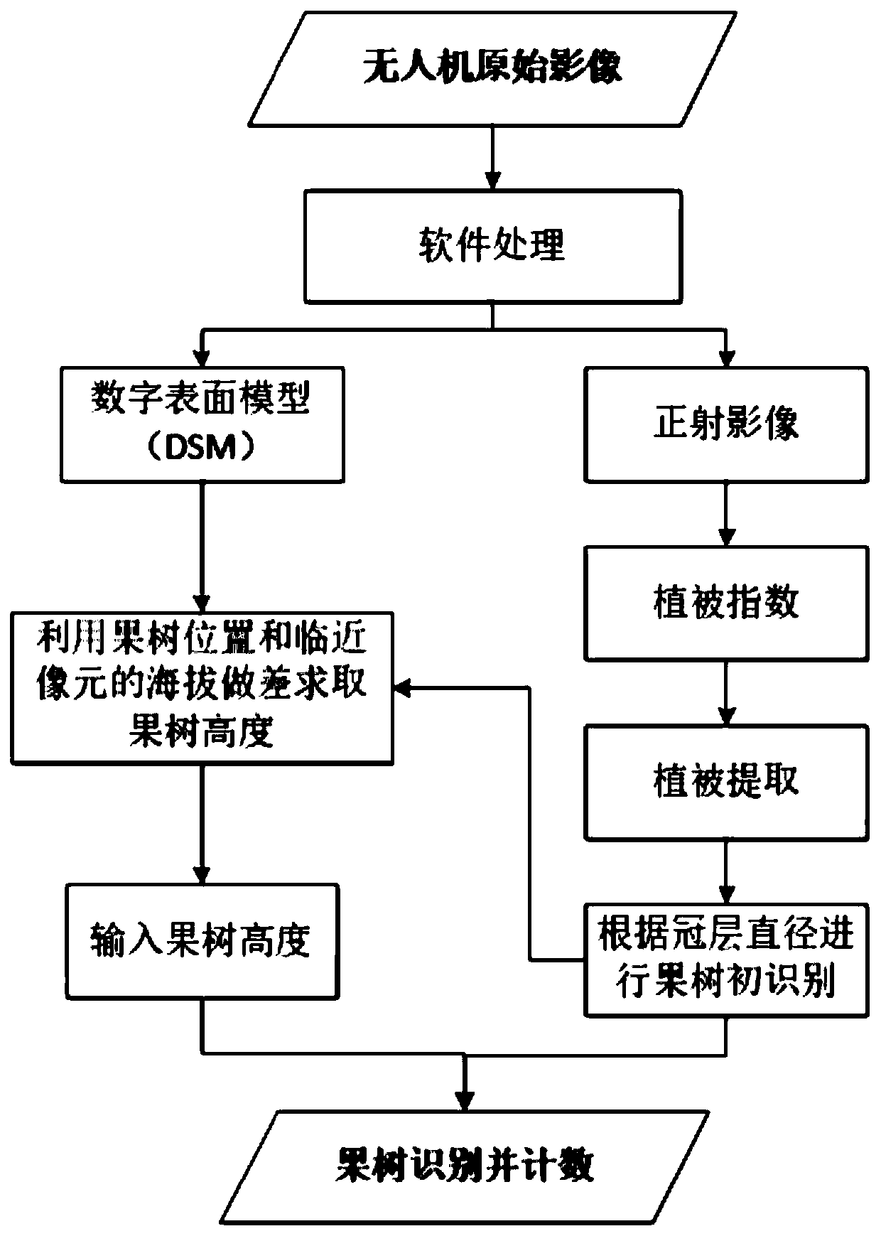
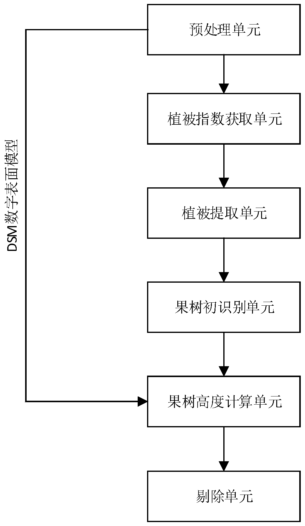
[0026] Such as Figure 1-2 As shown, a method for fruit tree identification and counting using drone images of the present invention includes:

[0027] S1, preprocessing the original image of the UAV, for example, through photoscan software to generate a digital surface model (DSM, Digital Surface Model) and orthophoto.

[0028] S2, calculate the vegetation index based on the orthophoto. Vegetation index is a simple, effective and empirical measurement of surface vegetation conditions based on the spectral characteristics of vegetation, combining visible light and near-infrared bands of images.

[0029] S3, Vegetation extraction: According to the nature of the vegetation index, the pixel ...


PUM


Abstract

The invention provides a method and system for identifying and counting fruit trees by utilizing unmanned aerial vehicle images, which comprises the steps of S1, preprocessing an original image of anunmanned aerial vehicle to generate a digital surface model and an ortho-image; S2, calculating a vegetation index based on the orthoimage; S3, identifying a vegetation area and a background accordingto the property of the vegetation index; S4, screening the fruit trees according to the known fruit tree diameter range and the spatial resolution of the image, and determining the positions and diameters of the fruit trees; and S5, substituting the preliminarily identified fruit tree position and diameter into the digital surface model, and subtracting the minimum value of the altitude close tothe fruit tree position from the maximum value of the altitude of the fruit tree to obtain the height of the fruit tree. The invention further provides a corresponding system. The invention provides anew thought so that the digital surface model synchronously generated by the unmanned aerial vehicle is used as a basis, the identified crop height is solved by using the digital surface model, and then secondary identification and counting are performed on the fruit trees according to the fruit tree height range, so that the fruit tree identification precision is improved.

Description

technical field [0001] The invention relates to a refined orchard management method, in particular to a method and system for identifying and counting fruit trees using drone images. Background technique [0002] The planting and management of fruit trees is an important part of the development of modern agriculture. According to the statistics of the Food and Agriculture Organization of the United Nations, the area of ​​fruit tree planting in the world accounts for about 3% to 4% of the total arable land (FAO, 2012). Accurately counting the number of fruit trees is very important for orchard yield estimation and planting management. Compared with the time-consuming, labor-intensive and highly subjective characteristics of traditional artificial fruit tree statistics, remote sensing technology can provide large-area and long-term necessary fruit tree information data due to its strong economy, good sustainability, and high reliability. An important way to ensure sustainable...

Claims


Application Information

Patent Timeline
IPC IPC(8): G06K9/00G06T7/00G06T7/62G06Q50/02
CPCG06T7/0002G06T7/62G06Q50/02G06T2207/30188G06T2207/30242G06V20/188
Inventor 史云段玉林张保辉吴文斌杨鹏唐华俊
Owner INST OF AGRI RESOURCES & REGIONAL PLANNING CHINESE ACADEMY OF AGRI SCI
Features
  • R&D
  • Intellectual Property
  • Life Sciences
  • Materials
  • Tech Scout
  • Unparalleled Data Quality
  • Higher Quality Content
  • 60% Fewer Hallucinations
Learn More