Non-growing season grass and livestock balance evaluation method based on unmanned aerial vehicle LIDAR aerial survey technology

A non-growing season, grass-stock balance technology, applied in the field of non-growing season grass-stock balance assessment, can solve problems such as inability to monitor herbivore data, achieve the effects of controlling sand and dust disasters, high investigation efficiency, and strong operability

A non-growing season, grass-stock balance technology, applied in the field of non-growing season grass-stock balance assessment, can solve problems such as inability to monitor herbivore data, achieve the effects of controlling sand and dust disasters, high investigation efficiency, and strong operability

CN110647786AActive Publication Date: 2020-01-03INST OF GEOGRAPHICAL SCI & NATURAL RESOURCE RES CAS +1

Image

  • Non-growing season grass and livestock balance evaluation method based on unmanned aerial vehicle LIDAR aerial survey technology
  • Non-growing season grass and livestock balance evaluation method based on unmanned aerial vehicle LIDAR aerial survey technology
  • Non-growing season grass and livestock balance evaluation method based on unmanned aerial vehicle LIDAR aerial survey technology

Examples


Embodiment Construction

[0056] In order to make the technical problems, technical solutions and advantages to be solved by the present invention clearer, the following will describe in detail with reference to the accompanying drawings and specific examples.

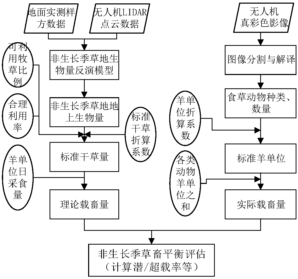
[0057] The present invention provides a non-growing season grass-stock balance evaluation method based on UAV LIDAR aerial survey technology, respectively based on UAV LIDAR point cloud and true color image to realize non-growing season grassland biomass estimation and herbivore interpretation, and then To assess the grass-livestock balance of non-growing season grasslands, the steps are as follows:

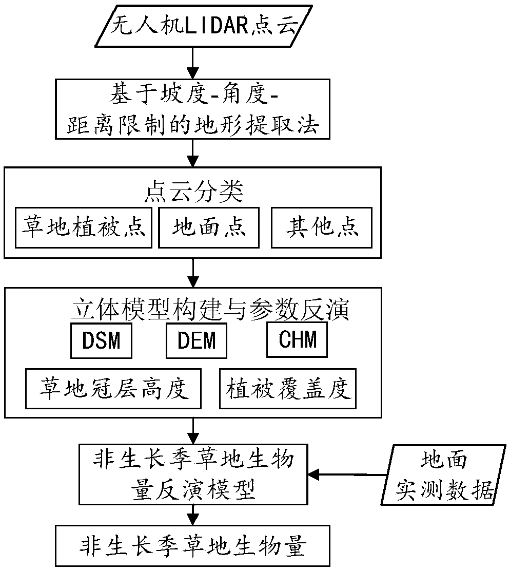
[0058] Step 1. Based on the slope-angle-distance restricted terrain extraction method, supervise and classify the UAV LIDAR point cloud data in the preset area, classify the point cloud into ground points, vegetation points, and other points, and then calculate the non-growing season Vegetation parameters such as grassland vegetation coverage and ...


PUM


Abstract

The invention provides a non-growing season grass and livestock balance evaluation method based on an unmanned aerial vehicle LIDAR aerial survey technology. The defect that dry vegetation and herbivorous animal information cannot be monitored through traditional satellite remote sensing can be effectively overcome; grassland balance monitoring is carried out for grassland in a withered grass period; the method comprises the following steps: classifying LIDAR point cloud data of the unmanned aerial vehicle based on a terrain extraction method of slope-angle-distance limitation, and calculatinggrassland vegetation coverage and canopy height in a non-growing season according to ground points and vegetation points obtained by classification to realize grassland above-ground biomass inversionin the non-growing season; based on an object-oriented and supervised classification method, obtaining parameters such as an available forage grass proportion and a grassland reasonable utilization rate, and calculating a theoretical livestock capacity; calculating the actual livestock capacity according to the herbivorous animal types, the herbivorous animal quantity and the sheep unit conversion formula of each animal; and finally, according to the theoretical livestock carrying capacity and the actual livestock carrying capacity, calculating the overload rate, the available days of the remaining forage grass and the forage grass amount needing supplementary feeding, and completing the evaluation of the non-growing season grass and livestock balance condition.

Description

technical field [0001] The invention relates to the technical field of UAV LIDAR point cloud and aerial image data processing, in particular to a non-growing season grass-stock balance evaluation method based on UAV LIDAR aerial survey technology Background technique [0002] my country is the country with the largest grassland area except Australia. The grassland area accounts for about 41.2% of the country's land area. More than 90% of the grasslands are severely degraded (Hou Xiangyang, 2014), and the rate is increasing by 2 million hectares every year. In order to protect, build and rationally utilize grasslands, the state promulgated the "Grassland Law" in 1985, and began to implement the system of "determining livestock by grass and balancing grass and livestock" on grasslands, and severely degraded, desertified, salinized, rocky and desertified. For grasslands in ecologically fragile areas, the system of grazing prohibition and rest grazing is implemented. In recent ...

Claims


Application Information

Patent Timeline
03 Jan 2020
Publication
CN110647786A
IPC
G06K9/00; G06K9/62; G06Q50/02
CPC
G06Q50/02; G06V20/188; G06F18/24
Inventors
王东亮