
Global positioning method based on geometric information

A positioning method and technology of geometric information, applied in the field of global positioning based on geometric information, can solve problems such as electromagnetic interference, mismatching, multi-path effects, etc., and achieve the effect of good positioning effect

Active Publication Date: 2020-01-14
NORTHEASTERN UNIV
View PDF9 Cites 16 Cited by
  • Summary
  • Abstract
  • Description
  • Claims
  • Application Information

AI Technical Summary

Problems solved by technology

However, the BOW bag-of-words model usually uses artificially constructed features and combines clustering algorithms to construct dictionary representation images, and uses dictionary histograms for image matching. It is still prone to mis-matching in complex environments such as lighting and occlusion.
GPS-based global positioning system is vulnerable to electromagnetic interference and multipath effects

Method used


Image

  • Global positioning method based on geometric information
  • Global positioning method based on geometric information

Examples


Embodiment Construction

[0030] The specific implementation manners of the present invention will be further described in detail below in conjunction with the accompanying drawings and embodiments. The following examples are used to illustrate the present invention, but are not intended to limit the scope of the present invention.

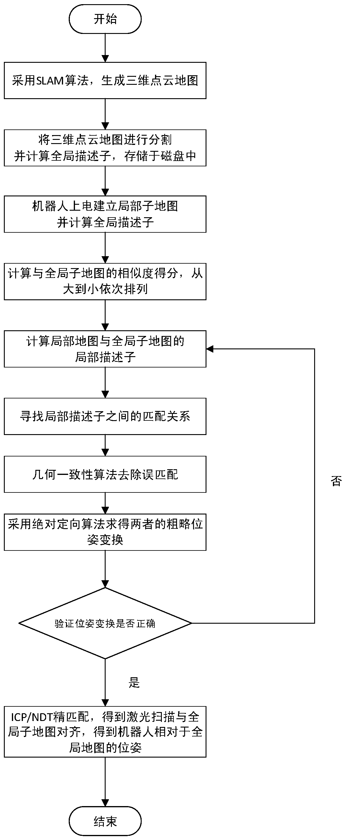
[0031] A global positioning method based on geometric information, such as figure 1 shown, including the following steps:

[0032] Step 1: Obtain the current perception information of the mobile robot for self-positioning, and use real-time positioning and map construction algorithms to generate a 3D point cloud map of the environment in advance;

[0033] The mobile robot is equipped with a laser range finder and a ROS operating system; the laser range finder is connected to the rigid body of the robot for building a map and doing global positioning based on the map. In this embodiment, VLP-16 laser radar is used, and the laser is The smallest three-dimensional laser pro...


PUM


Abstract

The invention provides a global positioning method based on geometric information, and relates to the technical field of autonomous positioning of mobile robots. According to the method, the current sensing information of the mobile robot is obtained, a three-dimensional point cloud map is generated by adopting an SLAM algorithm, the three-dimensional point cloud map is divided into global sub-maps, the robot moves to establish a local map, a global descriptor is calculated, an optimal local sub-map is found in the global sub-maps, the local descriptors of the optimal local sub-map and the global sub-maps are calculated, a corresponding relation of the local descriptors is found by utilizing a kd-tree, and error matching is removed by utilizing a geometric consistency algorithm; for the found corresponding relation, rough pose transformation of the local map and the global sub-maps is obtained by utilizing an absolute positioning algorithm; finally, fine matching is carried out by utilizing an ICP or NDT algorithm, the laser scanning and a global map are aligned finally, and the pose relation of the robot relative to the global map is obtained. The method is wide in application scene, the global positioning can be realized only by a laser range finder, and the method has the characteristics of easy operation and high precision.

Description

technical field [0001] The invention relates to the technical field of autonomous positioning of mobile robots, in particular to a global positioning method based on geometric information. Background technique [0002] Mobile robot localization is to determine the pose of the robot relative to a given map environment, known as pose estimation. According to whether the initial pose information is known, it is divided into position tracking and global positioning. Global positioning, the initial pose of the robot is considered unknown. The robot is initially placed somewhere in the environment, but unknown information about it is missing. The kidnapping robot problem is a variant of the global localization problem, but it is more difficult. During the run, the robot is kidnapped and teleported to another location. A localization algorithm can be tested by kidnapping a robot, which can be used to measure the algorithm's ability to recover from global localization failures. ...

Claims


Application Information

Patent Timeline
IPC IPC(8): G01C21/20
CPCG01C21/20G01C21/005
Inventor 方正金大平张伟义陈勇南孔德磊
Owner NORTHEASTERN UNIV
Learn More