Ad-hoc network marine environment multi-parameter measurement method

A marine environment and measurement method technology, applied in the direction of measurement devices, instruments, etc., can solve problems such as low measurement efficiency and inability to enter dangerous sea areas, and achieve the effects of increasing measurement efficiency, improving the intelligence of surveying and mapping, and improving the efficiency of surveying and mapping

Inactive Publication Date: 2020-01-17
北京方位智能系统技术有限公司
View PDF5 Cites 8 Cited by
  • Summary
  • Abstract
  • Description
  • Claims
  • Application Information

AI Technical Summary

Problems solved by technology

[0003] The purpose of the present invention is to provide a multi-parameter measurement method for the marine environment of an ad hoc network. Through this system, the unmanned surface craft measurement platform can be networked to simultaneously perform seabed topography and landform surveying, ocean current profile measurement and underwater obstacles on the water surface. The detection work realizes the formation distribution of unmanned surface vehicles to complete the multi-beam, acoustic Doppler velocity and current synchronous measurement and real-time splicing functions, the local storage function of measurement data, the mother ship / shore-based remote command unmanned surface vehicle autonomous measurement operations, etc. Improve the efficiency of existing surveys, and can replace existing survey ships to perform survey tasks in dangerous sea areas and shoal waters, thereby solving the problems of low measurement efficiency and inability to enter dangerous sea areas for conventional survey ships

Method used


Image

  • Ad-hoc network marine environment multi-parameter measurement method
  • Ad-hoc network marine environment multi-parameter measurement method
  • Ad-hoc network marine environment multi-parameter measurement method

Examples


Embodiment Construction

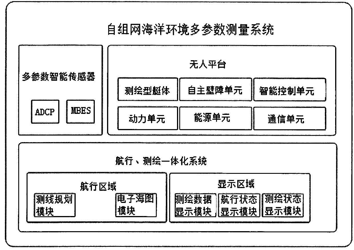
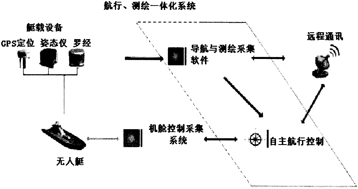
[0025] Refer to attached Figures 1 to 4 As shown, the multi-parameter measurement method of the ad hoc network marine environment includes multi-parameter smart sensors, unmanned platforms and navigation, surveying and mapping integrated systems, multi-parameter smart sensors include multi-beam echo sounder (MBES, MultiBeam Echo Sounder) and acoustic multi- Acoustic Doppler Current Profilers (ADCP, Acoustic Doppler Current Profilers), MBES is used for seabed topography and landform measurement, ADCP is used for ocean current profile measurement; unmanned platform includes surveying and mapping hull, autonomous obstacle avoidance unit, intelligent control unit, power unit, energy source unit, communication unit; navigation, surveying and mapping integrated system includes surveying line planning, electronic chart, navigation status display, surveying and mapping status display, and surveying and mapping data display modules.

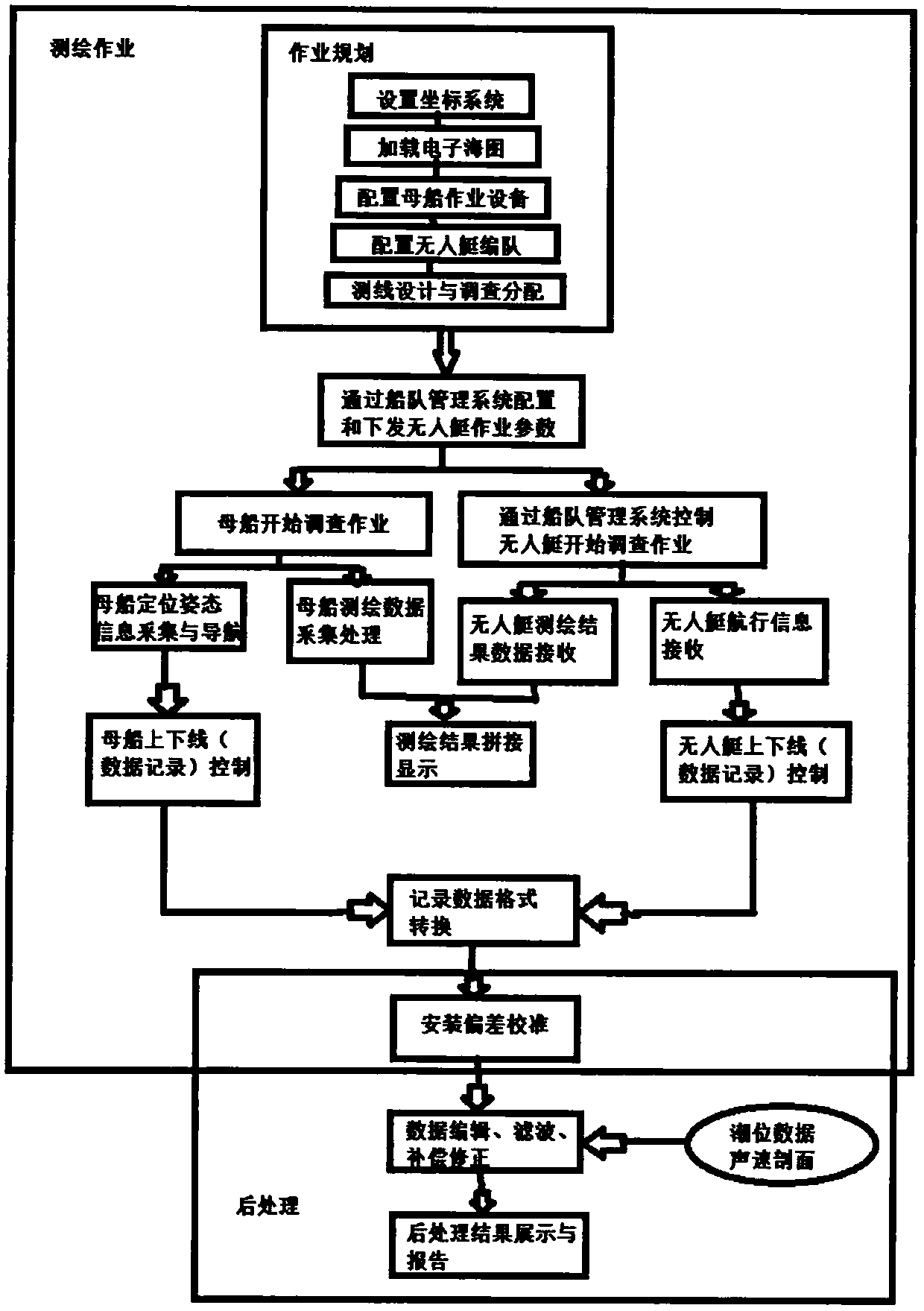
[0026] The specific implementation includes the fo...


PUM


Abstract

The invention provides an ad-hoc network marine environment multi-parameter measurement method. A plurality of unmanned platforms are used for carrying marine environment measurement sensors, and a navigation, surveying and mapping integrated system is used in cooperation to realize networking measurement. The navigation, surveying and mapping integrated system runs in a shore-based or mother shipoperation management center and controls and coordinates the plurality of measurement sensors to work. The measurement sensors comprise a multi-beam echo sounder and an acoustic Doppler velocity profiler, and provides marine environment data acquisition. The unmanned platform is formed by integrating a surveying and mapping type hull, an autonomous obstacle avoidance unit and an intelligent control unit, and is used as a mobile platform for measuring networking measurement of the measurement sensors. The navigation and surveying and mapping integrated system is formed by integrating a collaborative management software module, a surveying and mapping operation module and a multi-source multi-platform surveying and mapping data real-time splicing module, and networking operation and data post-processing are realized. The networking measurement method has the characteristics of high measurement efficiency, high platform and sensor compatibility and the high multi-instrument networking observation and multi-source data fusion level.

Description

technical field [0001] The invention relates to the technical field of marine surveying and mapping, and more specifically relates to a method for measuring multi-parameters of an ad hoc network marine environment. Background technique [0002] Marine surveying and mapping is the foundation and precursor of all marine activities. While attaching great importance to marine security and the development of marine economy at home and abroad, they are also paying more attention to the development of marine surveying and mapping. In order to fully perform their duties, the surveying and mapping business workload of the marine surveying department has remained high in recent years, and emergency surveying and mapping has gradually developed to near and far seas. The number of surveying and mapping tasks in island reef areas and complex sea areas has increased, and the requirements for maritime surveying and mapping equipment have become higher and higher. Due to the harsh sea cond...

Claims


Application Information

Patent Timeline
Patent Type & Authority Applications(China)
IPC IPC(8): G01D21/02
CPCG01D21/02
Inventor 徐明洪在地
Owner 北京方位智能系统技术有限公司
Why Eureka
Try Eureka