
A method to quickly obtain the predicted parameters of mining subsidence by using unmanned aerial vehicle technology

A mining subsidence and unmanned aerial vehicle technology, applied in computing, data processing applications, complex mathematical operations, etc., can solve problems such as difficult protection, small amount of data, time-consuming and labor-intensive, etc., to reduce labor intensity, save time and cost , the effect of improving the efficiency of parameter seeking

Active Publication Date: 2022-04-26
CHINA UNIV OF MINING & TECH +1
View PDF8 Cites 0 Cited by
  • Summary
  • Abstract
  • Description
  • Claims
  • Application Information

AI Technical Summary

Problems solved by technology

[0005] In view of the above analysis, the embodiment of the present invention aims to provide a method of quickly obtaining the estimated parameters of mining subsidence in mining areas by using UAV technology, so as to solve the problem of time-consuming and labor-consuming monitoring of mining subsidence in existing mining areas, small amount of data, and the need to bury and fix The problem of measuring points and not easy to protect

Method used


Image

  • A method to quickly obtain the predicted parameters of mining subsidence by using unmanned aerial vehicle technology
  • A method to quickly obtain the predicted parameters of mining subsidence by using unmanned aerial vehicle technology
  • A method to quickly obtain the predicted parameters of mining subsidence by using unmanned aerial vehicle technology

Examples


Embodiment 1

[0050]This embodiment discloses a method for quickly obtaining the estimated parameters of mining subsidence in mining areas by using UAV technology. The main steps are as follows: Establish a UAV surface mobile observation station within the mining area → use UAVs to conduct multi-phase mining subsidence Dynamic monitoring, completion of field data collection → internal data processing of field data obtained by drones, each period of monitoring data generates a corresponding mine surface DEM (Digital Elevation Model, digital elevation model), and multi-period monitoring data formation Multi-period DEM of the subsidence area, get the surface subsidence value of the mining area by subtracting the multi-period DEM → use the probability integral dynamic prediction model to invert to obtain the estimated surface subsidence parameters → use the inversion obtained surface subsidence estimated parameters for the mining area and surrounding areas Prediction of subsidence in the mining ...

Embodiment 2

[0082] This embodiment discloses a method for quickly obtaining the predicted parameters of mining subsidence in a mining area by using unmanned aerial vehicle technology, which is applied to the Wangjiata Coal Mine in Inner Mongolia.

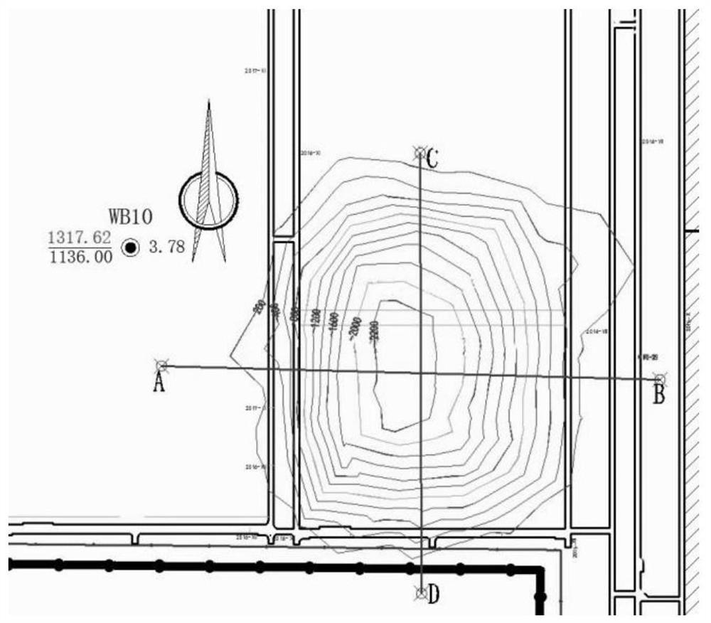
[0083] Overview of the research area: Wangjiata Coal Mine 2S201 working face is located in Ordos City, Inner Mongolia Autonomous Province. The working face has a strike length of about 1253m, a dip length of about 260m, an average coal seam inclination of 2°, a mining depth of about 200m, and an average mining thickness of 3.26m, see the table below for specific parameters.

[0084]

[0085] The boundary angle is used to draw the mining influence range of the 2S201 working face, and the boundary angle is 45°, and the control point layout position of the influence boundary image is obtained. Since the range is smaller this time, the flight range covers the entire area of ​​influence.


PUM


Abstract

The invention relates to a method for quickly obtaining the estimated parameters of mining subsidence in mining areas by using unmanned aerial vehicle technology, which belongs to the technical field of mining subsidence in mining areas, and solves the problem of time-consuming and labor-intensive monitoring of mining subsidence in the prior art, small data volume, and the need to bury fixed measuring points and difficult to protect. The method steps of the present invention include: establishing a UAV ground surface mobile observation station within the mining range; using the UAV to conduct multi-phase dynamic monitoring of the mine area surface subsidence, and completing field data collection; Industrial data processing, each period of monitoring data generates the corresponding mining area surface DEM, multi-period monitoring data forms multi-period DEM of the subsidence area, and the mining area surface subsidence value is obtained by subtracting the multi-period DEM; using the probability integral dynamic prediction model, the inversion is calculated Take the predicted parameters of surface subsidence; use the obtained predicted parameters of surface subsidence to predict the mining surface subsidence of the mining area and other surrounding mining areas.

Description

technical field [0001] The invention relates to the technical field of mining subsidence in mining areas, in particular to a method for quickly obtaining predicted parameters of mining area mining subsidence by using unmanned aerial vehicle technology. Background technique [0002] The prediction of mining subsidence is one of the core contents of mining subsidence science, and it has great significance to the theoretical research and production practice of mining subsidence. The prediction results of mining subsidence are often used to judge whether the ground buildings (structures) are affected by mining and the extent of the impact of mining, as a basis for repairing, strengthening, rebuilding on the spot or taking underground measures for the buildings (structures). The subsidence prediction parameters are the key to determine whether the prediction is accurate or not. [0003] At present, the main parameter-seeking model is the probability integral steady-state paramet...

Claims


Application Information

Patent Timeline
Patent Type & Authority Patents(China)
IPC IPC(8): G06F30/20G06F17/18G06Q50/02G01C11/00G01C15/00
CPCG06F17/18G06Q50/02G01C11/00G01C15/00
Inventor 周大伟张德民吴侃周宝慧郭良林亓立壮
Owner CHINA UNIV OF MINING & TECH
Learn More