Method for reconstructing vertical rainfall field based on satellite-ground link scanning

A satellite-ground link and rainfall field technology, applied in the field of meteorological detection, can solve problems such as increasing operating costs, low time resolution, inability to achieve real-time rainfall monitoring, and difficulty in measuring rainfall.

Active Publication Date: 2020-02-28
NAT UNIV OF DEFENSE TECH
View PDF6 Cites 12 Cited by
  • Summary
  • Abstract
  • Description
  • Claims
  • Application Information

AI Technical Summary

Problems solved by technology

Among them, rain gauges can only realize rainfall observation in horizontal areas through networking, and it is difficult to deploy and maintain them in inaccessible areas such as deserts and rainforests, which increases operating costs; weather radar can detect rainfall in three-dimensional space, and the temporal and spatial resolution It is relatively high, but it is easily affected by ground clutter at low elevation angles and it is difficult to measure rainfall near the ground; meteorological satellites can observe three-dimensional rainfall on a global scale, because the same area can only be observed twice a day, the time resolution is too high Low can not meet the requirements of real-time monitoring of rainfall

Method used


Image

  • Method for reconstructing vertical rainfall field based on satellite-ground link scanning
  • Method for reconstructing vertical rainfall field based on satellite-ground link scanning
  • Method for reconstructing vertical rainfall field based on satellite-ground link scanning

Examples


Embodiment Construction

[0035] The present invention will be further described below in conjunction with the accompanying drawings and specific embodiments.

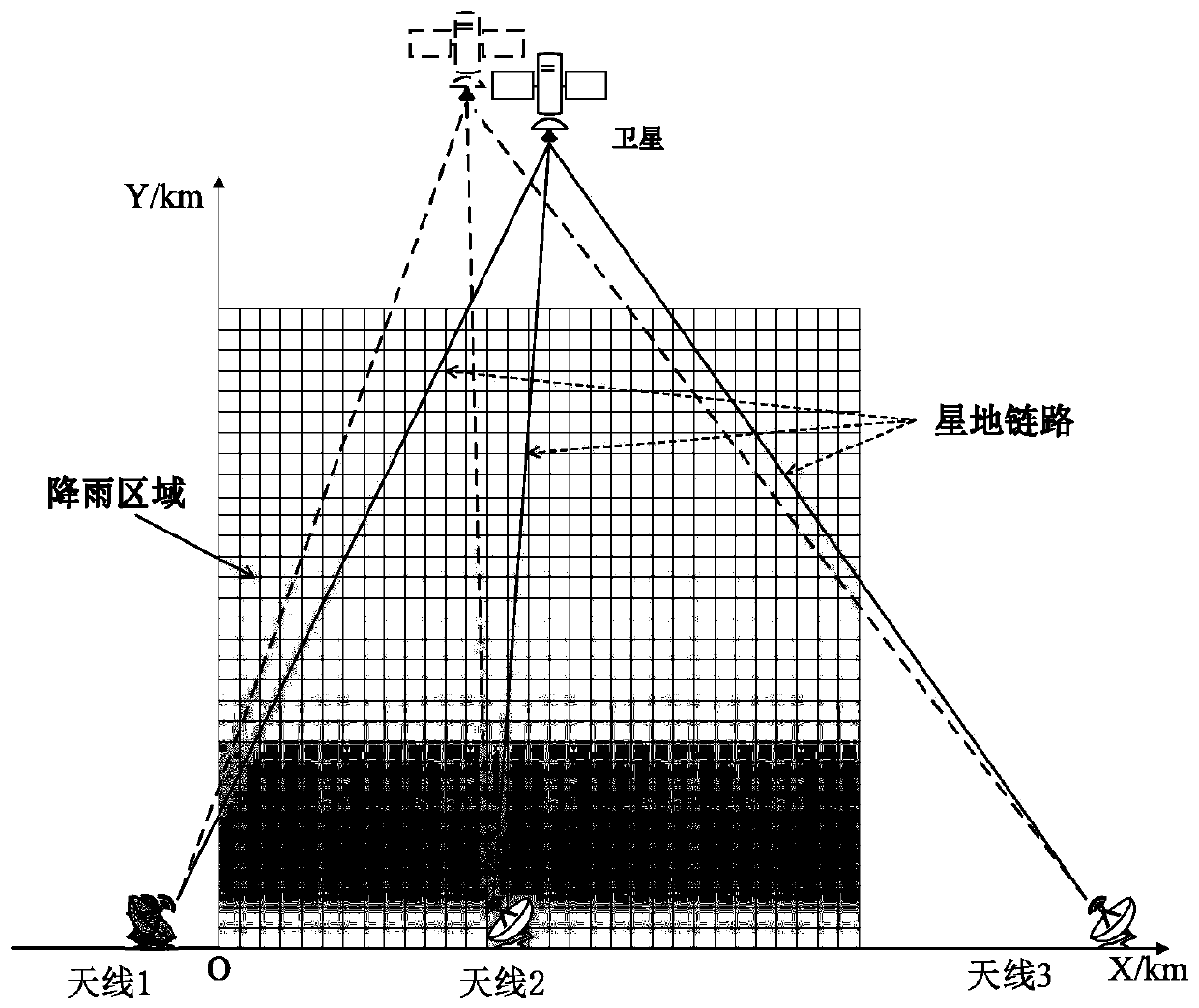
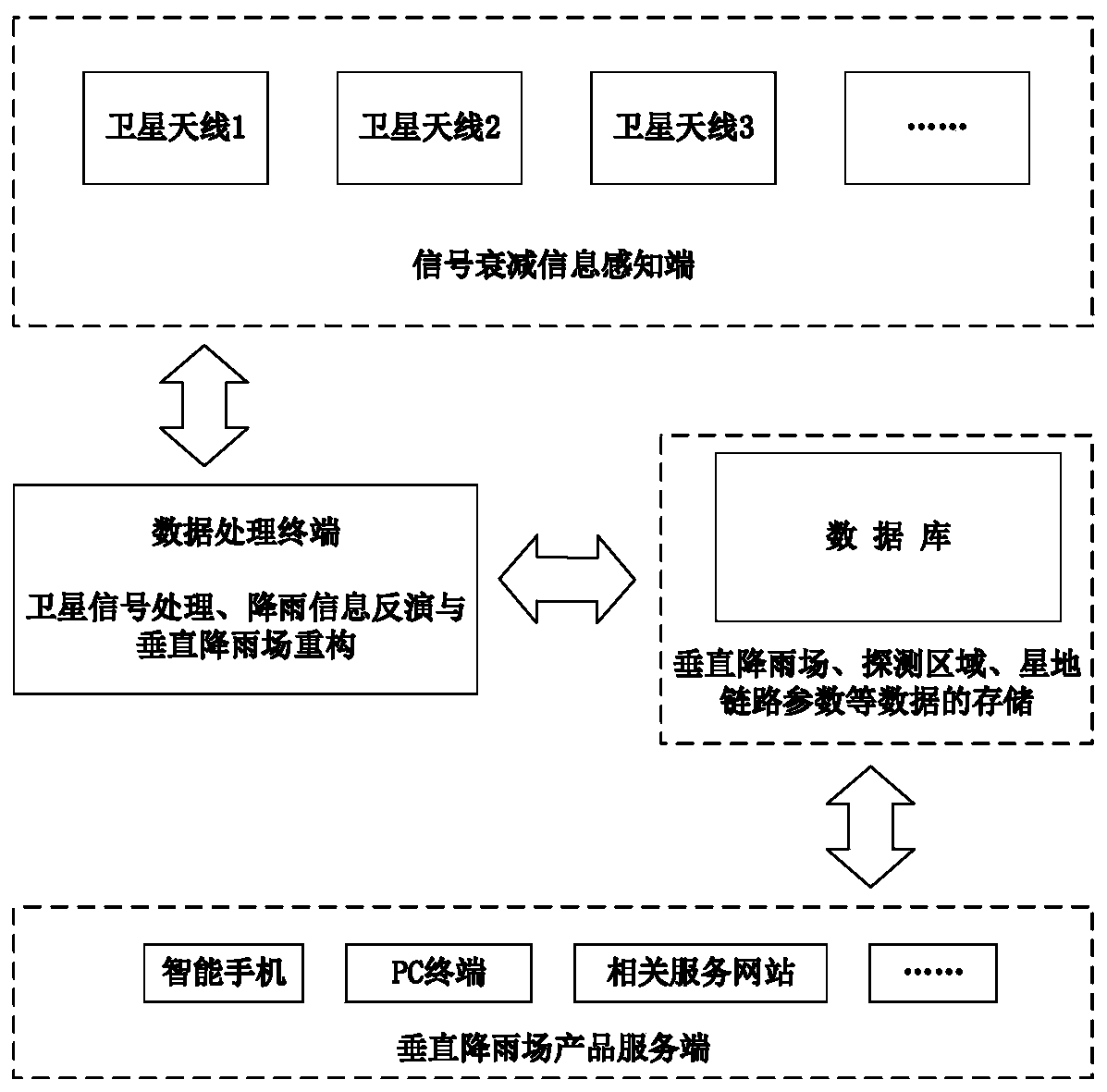
[0036] At first provide a kind of system that can be used for realizing the method described in the present invention, this system is as figure 2 As shown, it includes: signal attenuation information perception terminal, data processing terminal, database and vertical rainfall product server. Wherein, the signal attenuation information sensing end specifically refers to a satellite signal receiving end, such as a satellite antenna, which is used to receive satellite signals, and to receive satellite signals and antenna position information (x i ,y i ) and satellite position information Incoming data processing terminal and database; data processing terminal specifically completes satellite signal processing (extracting frequency information f from satellite signal i and intensity information p i ), rainfall information inversion and verti...


PUM


Abstract

The invention provides a method for reconstructing a vertical rainfall field based on satellite-ground link scanning, and the method comprises the steps: building a plurality of satellite signal receiving ends to receive polar orbit satellite signals, and forming a plurality of satellite-ground links; meshing a vertical region to be reconstructed; obtaining the spatial distribution of attenuationcoefficients by analyzing the relation among satellite-ground link signal strength information, rainfall attenuation coefficients and satellite-ground link lengths, performing the inversion of the spatial distribution of rainfall according to a relation model of the attenuation coefficients and the rainfall strength, and generating rainfall information in a vertical space; and finally, reconstructing the vertical rainfall field by combining with a detection area. The method not only makes up the defects of the traditional means for detecting the vertical rainfall field, but also has the advantages of high temporal-spatial resolution, low cost and the like, and provides important data support and guarantee for water resource management, agricultural development, natural disaster early warning and the like.

Description

technical field [0001] The invention relates to the field of meteorological detection, in particular to a method for reconstructing a vertical rain field based on satellite-ground link scanning. Background technique [0002] Monitoring the vertical distribution of rainfall plays an important role in water resources management, agricultural development and natural disasters (debris flow, flood, etc.) early warning. Traditional means of detecting rainfall include rain gauges, weather radar and weather satellites. Among them, rain gauges can only realize rainfall observation in horizontal areas through networking, and it is difficult to deploy and maintain them in inaccessible areas such as deserts and rainforests, which increases operating costs; weather radar can detect rainfall in three-dimensional space, and the temporal and spatial resolution It is relatively high, but it is easily affected by ground clutter at low elevation angles, and it is difficult to measure rainfall...

Claims


Application Information

Patent Timeline
Patent Type & Authority Applications(China)
IPC IPC(8): G01W1/14G06F17/11G06F17/16
CPCG01W1/14G06F17/11G06F17/16
Inventor 刘西川咸明皓高太长胡帅刘磊
Owner NAT UNIV OF DEFENSE TECH
Why Eureka
Try Eureka