Satellite remote sensing image instant service method and satellite remote sensing image instant service platform

A technology of satellite remote sensing image and service method, which is applied in the field of satellite remote sensing image real-time service method and real-time service platform, and achieves the effect of satisfying real-time monitoring or real-time update and release, and reducing application difficulty and processing cost.

Active Publication Date: 2020-04-07
自然资源部国土卫星遥感应用中心
View PDF6 Cites 11 Cited by
  • Summary
  • Abstract
  • Description
  • Claims
  • Application Information

AI Technical Summary

Problems solved by technology

[0005] The purpose of the present invention is to provide a satellite remote sensing image real-time service method and real-time service platform, thereby solving the aforementioned problems existing in the prior art

Method used


Image

  • Satellite remote sensing image instant service method and satellite remote sensing image instant service platform
  • Satellite remote sensing image instant service method and satellite remote sensing image instant service platform
  • Satellite remote sensing image instant service method and satellite remote sensing image instant service platform

Examples


Embodiment 1

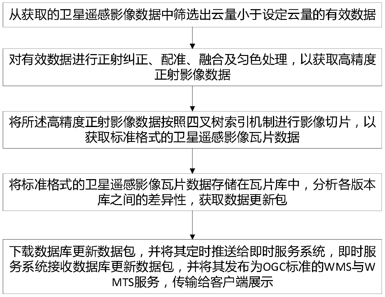
[0040] Such as figure 1 As shown, a method for instant service of satellite remote sensing images is provided in this embodiment, comprising the following steps,

[0041] S1. From the obtained satellite remote sensing image data, filter out the effective data whose cloud cover is less than the set cloud cover;

[0042] S2. Perform orthorectification, registration, fusion and color uniform processing on the effective data to obtain high-precision orthophoto data;

[0043] S3. Slicing the high-precision orthophoto image data according to the quadtree indexing mechanism to obtain satellite remote sensing image tile data in a standard format;

[0044] S4. Store the satellite remote sensing image tile data in the standard format in the tile library, analyze the differences between the versions of the library, and obtain the data update package;

[0045] S5, download the database update data package, and push it regularly to the instant service system, and the instant service syst...

Embodiment 2

[0114] An instant service platform for satellite remote sensing images is provided in this embodiment, and the instant service platform is used to implement an instant service method; the instant service platform includes a master server and a plurality of front-end servers, the version library and the After the database is established, each of the front-end servers sends a download signal to the main server, and the main server analyzes the difference between the version libraries according to the download request of each front-end server, obtains the data update package, and distributes it to Each front-end server.

[0115]In this embodiment, each of the front-end servers downloads the data update package, and decompresses and updates it to each instant service system; the instant service system receives the request URL (Uniform Resource Locator, Uniform Resource Locator) ), from which extract the parameters that meet the OGC standard, and analyze the parameters, and convert...


PUM


Abstract

The invention discloses a satellite remote sensing image instant service method and a satellite remote sensing image instant service platform. The satellite remote sensing image instant service methodcomprises the following steps: S1, screening effective data of which the cloud amount is smaller than a set cloud amount from acquired satellite remote sensing image data; S2, performing ortho-rectification, registration, fusion and color homogenization processing on the effective data to obtain high-precision ortho-image data; S3, performing image slicing on the high-precision orthoimage data according to a quadtree index mechanism to obtain satellite remote sensing image tile data in a standard format; and S4, storing the satellite remote sensing image tile data in the standard format in atile library, analyzing the difference between version libraries, and obtaining a data update package; and the like. The satellite remote sensing image instant service method has the advantages that the application difficulty and the processing cost of using the remote sensing image by a user are reduced; the problems of tedious and complex data processing, management and storage in the remote sensing image application process are solved; and the requirement of the user for real-time monitoring or real-time updating and publishing is met.

Description

technical field [0001] The invention relates to the technical field of satellite remote sensing image processing, in particular to an instant service method and an instant service platform for satellite remote sensing images. Background technique [0002] In recent years, a series of important breakthroughs have been made in the development of my country's surveying, mapping and geographic information industry, and the capabilities of surveying and mapping technology and equipment have been significantly improved; domestic high-resolution satellites such as "Gaofen-1", "Ziyuan-3" and "Gaofen-2" have successively succeeded Launched, the Beidou satellite navigation system has formed a location service capability covering the Asia-Pacific region, and the equipment capabilities in drone aerial remote sensing, geographic information emergency monitoring, and synthetic aperture radar mapping have been greatly improved. Features such as image acquisition capability and better image r...

Claims


Application Information

Patent Timeline
Patent Type & Authority Applications(China)
IPC IPC(8): G06F16/51G06F16/901G06F16/587G06F16/29G06T5/00G06T5/50G06T3/60G06T7/33
CPCG06F16/29G06F16/51G06F16/587G06F16/9027G06T3/608G06T5/006G06T5/50G06T7/337G06T2207/10032G06T2207/20221
Inventor 王光辉王华斌刘慧杰刘津王玉刘宇陈晨
Owner 自然资源部国土卫星遥感应用中心
Why Eureka
Try Eureka