Agricultural flood disaster range monitoring system and method based on high-resolution satellite remote sensing image

A technology for satellite remote sensing images and flood disasters, which is applied in image enhancement, image analysis, image data processing, etc., and can solve problems such as inability to obtain flood disaster information and unclear monitoring images

Pending Publication Date: 2020-04-14
INST OF AGRI RESOURCES & REGIONAL PLANNING CHINESE ACADEMY OF AGRI SCI
View PDF4 Cites 19 Cited by
  • Summary
  • Abstract
  • Description
  • Claims
  • Application Information

AI Technical Summary

Problems solved by technology

[0004] The existing monitoring technology based on high-resolution satellite remote sensing images for agricultural flood disaster range monitoring images is not clear; at the same time, accurate flood disaster information cannot be obtained

Method used


Image

  • Agricultural flood disaster range monitoring system and method based on high-resolution satellite remote sensing image
  • Agricultural flood disaster range monitoring system and method based on high-resolution satellite remote sensing image
  • Agricultural flood disaster range monitoring system and method based on high-resolution satellite remote sensing image

Examples


Embodiment Construction

[0067] In order to further understand the content, features and effects of the present invention, the following examples are given, and detailed descriptions are given below with reference to the accompanying drawings.

[0068] The structure of the present invention will be described in detail below in conjunction with the accompanying drawings.

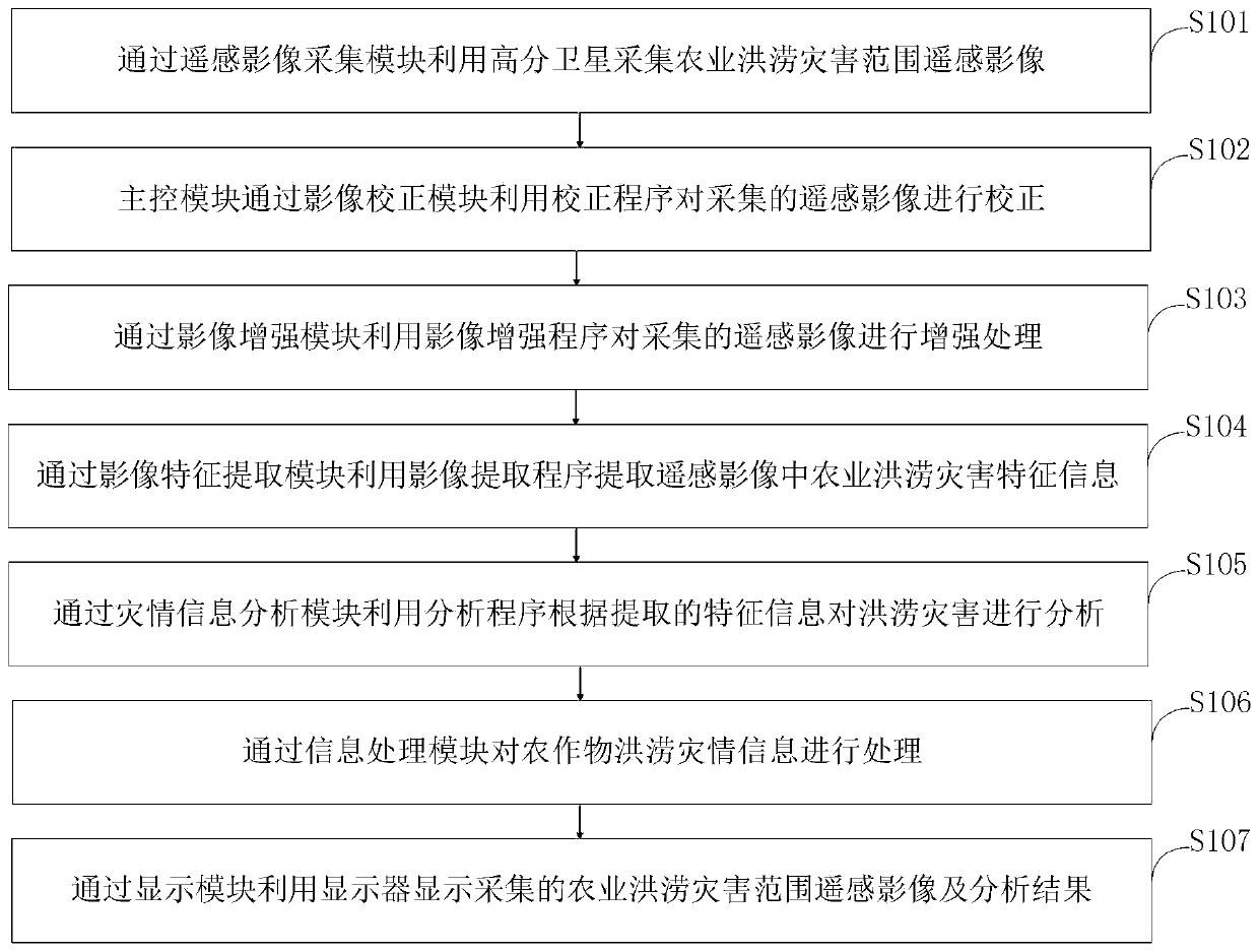
[0069] Such as figure 1 As shown, the method for monitoring the range of agricultural flood disasters based on high-resolution satellite remote sensing images provided by the present invention includes the following steps:

[0070] Step S101, collecting remote sensing images of the agricultural flood disaster range through the remote sensing image acquisition module using high-resolution satellites;

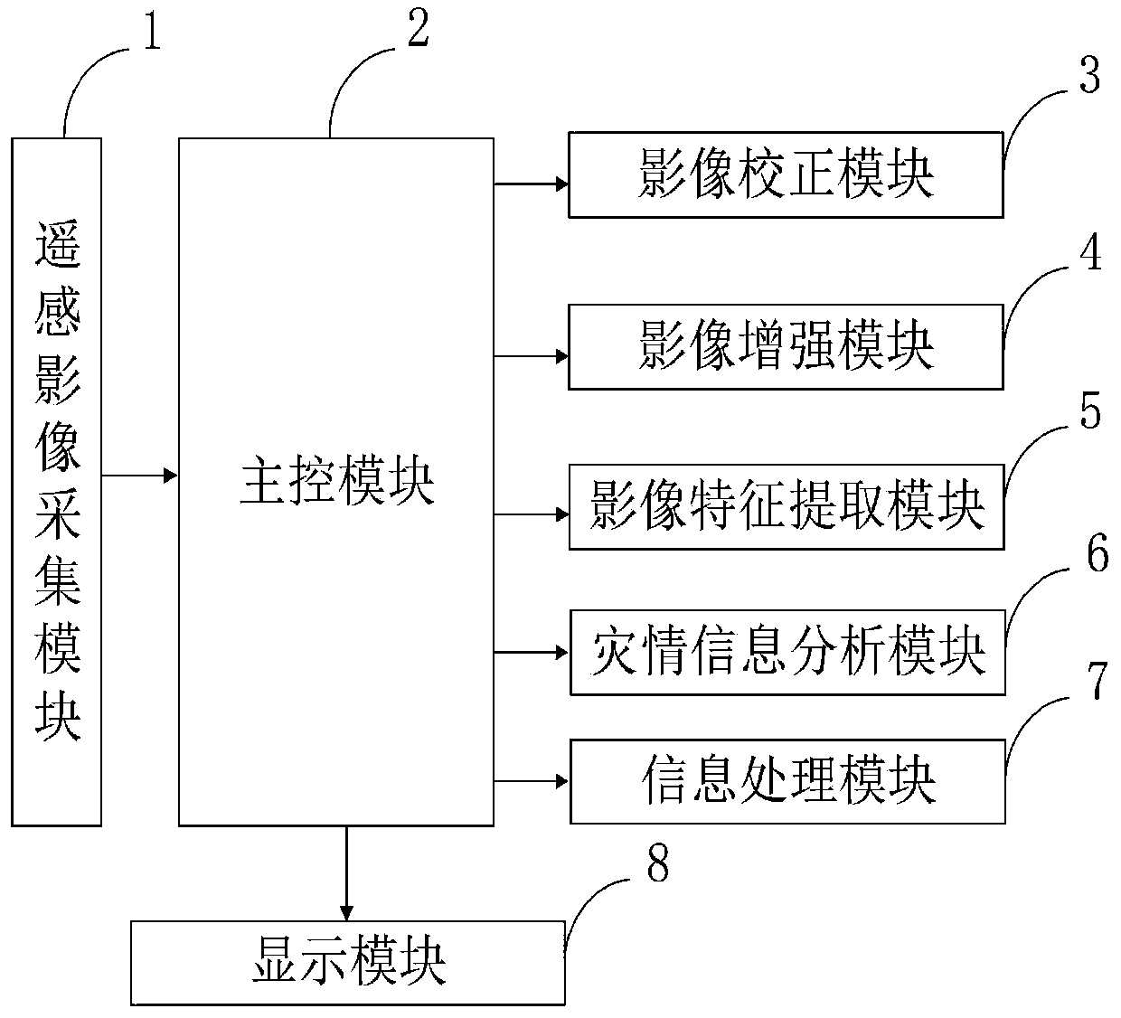
[0071] Step S102, the main control module corrects the collected remote sensing images through the image correction module using a correction program;

[0072] Step S103, using an image enhancement program to enhance the collected rem...


PUM


Abstract

The invention belongs to the technical field of agricultural flood disaster range monitoring. The invention discloses an agricultural flood disaster range monitoring system and method based on a high-resolution satellite remote sensing image. The agricultural flood disaster range monitoring system based on the high-resolution satellite remote sensing image comprises a remote sensing image acquisition module, a main control module, an image correction module, an image enhancement module, an image feature extraction module, a disaster information analysis module, an information processing moduleand a display module. Through the image enhancement module, the definition of the acquired remote sensing image can be greatly improved; meanwhile, various information data can be processed through the information processing module. The processing efficiency and utilization rate of multi-source data are improved. A model is constructed to improve the precision and accuracy of the model. The modelis used to accurately extract water body information. The flood disaster dynamic development situation of a river reach or a tributary is monitored and preliminarily evaluated, which lays a foundation for providing accurate disaster information service for river basin flood disasters.

Description

technical field [0001] The invention belongs to the technical field of agricultural flood disaster range monitoring, and in particular relates to a monitoring system and method for agricultural flood disaster range based on high-resolution satellite remote sensing images. Background technique [0002] Flood refers to the phenomenon that low-lying areas are submerged and waterlogged due to heavy rain, heavy rain or continuous rainfall. Rainwater mainly harms the growth of crops, causes crop yield reduction or failure, and disrupts the normal development of agricultural production and other industries. Floods can be divided into river floods, lake lake floods and storm floods. Among them, river floods can be divided into the following types according to different causes: storm floods, mountain torrents, snowmelt floods, ice floods and dam-break floods. The most influential and common flood is the river flood, especially the long-term torrential rain in the basin caused the r...

Claims


Application Information

Patent Timeline
Patent Type & Authority Applications(China)
IPC IPC(8): G06T5/00G06T7/11G06T7/13G06Q10/06G06F30/20
CPCG06T5/002G06T5/006G06T7/11G06T7/13G06Q10/0635G06T2207/10032Y02A10/40
Inventor 覃志豪李文娟
Owner INST OF AGRI RESOURCES & REGIONAL PLANNING CHINESE ACADEMY OF AGRI SCI
Why Eureka
Try Eureka