Field-free geometric calibration method and system for satellite-borne laser altimeter

A laser altimeter and geometric calibration technology, which is applied in the field of aerospace photogrammetry, can solve the problems of limitations and the large difference in the accuracy of laser geometric pointing and calibration, and achieve the effect of solving the inaccurate initial pointing

Inactive Publication Date: 2020-04-24
WUHAN UNIV
View PDF5 Cites 4 Cited by
  • Summary
  • Abstract
  • Description
  • Claims
  • Application Information

AI Technical Summary

Problems solved by technology

Usually after the satellite is in orbit, the geometric pointing of the laser is quite diffe

Method used


Image

  • Field-free geometric calibration method and system for satellite-borne laser altimeter
  • Field-free geometric calibration method and system for satellite-borne laser altimeter
  • Field-free geometric calibration method and system for satellite-borne laser altimeter

Examples


Embodiment 1

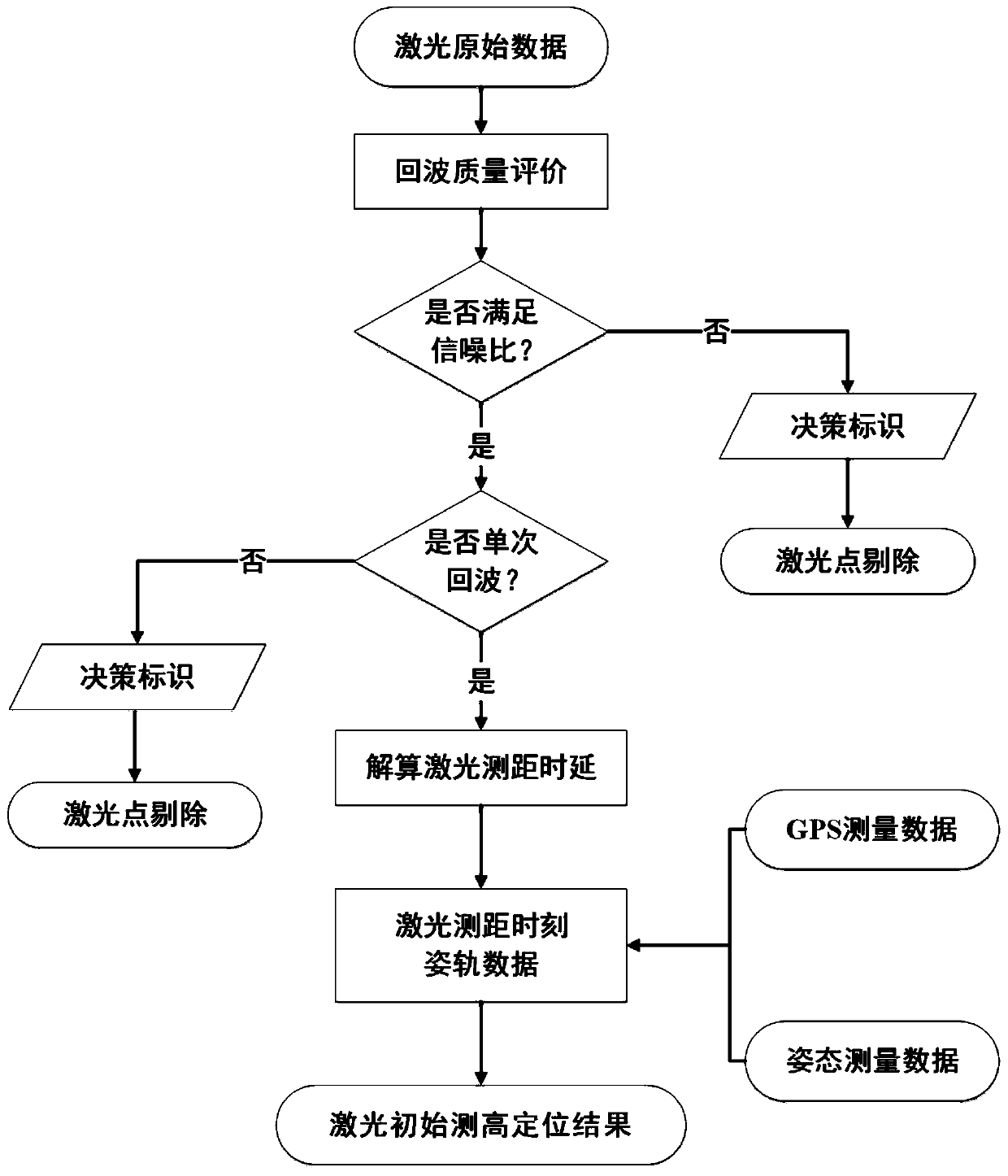
[0073] This embodiment will provide a geometric positioning method for spaceborne laser altimetry. For the process, see figure 1 .

[0074] The basic principles of spaceborne laser geometric positioning are as follows:

[0075] The position coordinates of the laser are denoted by S, the coordinates of the center of the earth are R, and the distance from the center of the earth is RS. It emits a laser signal to reach point A on the surface of the earth. The measured distance value is ρ. The distance from the laser measurement point A to the center of the earth is RA.

[0076] From this, the strict geometric positioning model of spaceborne laser altimetry is obtained, that is, the distance equation, and its object space form can be described as the following formula:

[0077]

[0078] in, Represents the position of the satellite in the earth-centered Cartesian coordinate system, R(t) is the rotation matrix from the body coordinate system to the earth-centered Cartesian co...

Embodiment 2

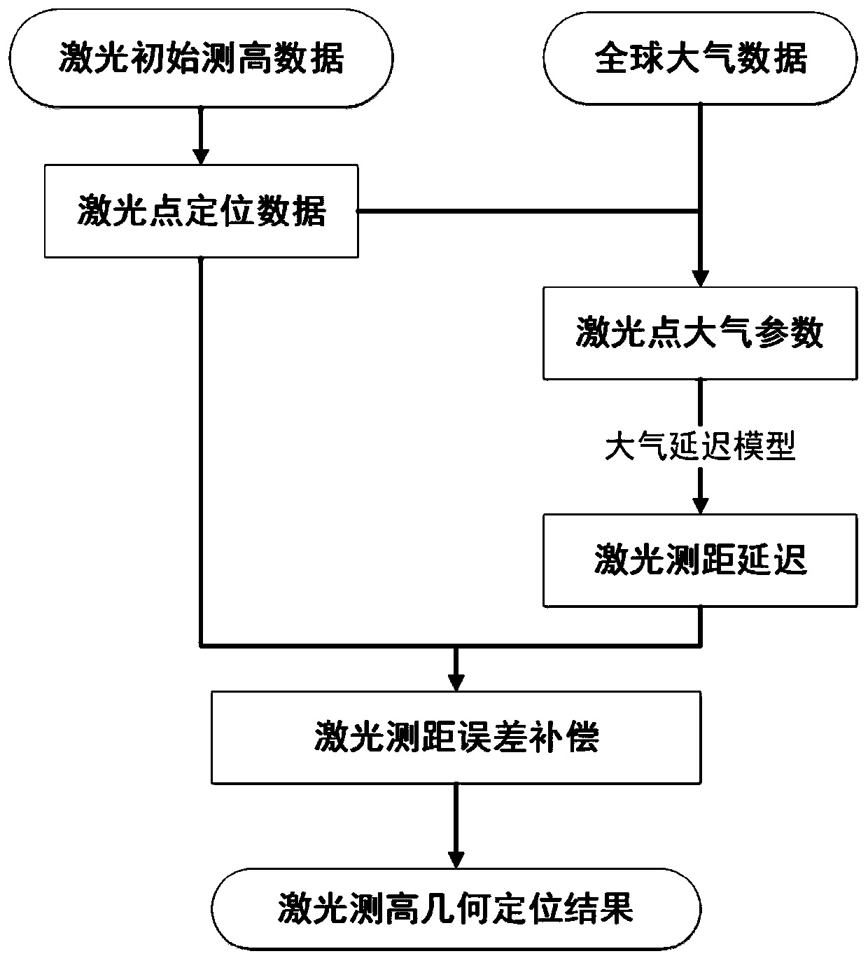
[0086] This embodiment provides a method for correcting atmospheric delay in spaceborne laser ranging, see attached figure 2 .

[0087] The path of laser propagation in the atmosphere is different from the straight-line propagation in vacuum. The influence of the atmosphere on laser ranging mainly includes atmospheric delay and atmospheric refraction, and the most important factor affecting laser ranging is atmospheric delay. During the propagation of laser in the atmosphere, the observation accuracy of the laser altimetry system is greatly limited due to the influence of atmospheric refraction. Therefore, the atmospheric delay error of laser ranging must be corrected before on-orbit calibration of the laser.

[0088] Atmospheric delay correction is mainly to eliminate the ranging delay error caused by the refraction of the atmosphere when the laser passes through the troposphere. Assuming that the propagation speed v of the electromagnetic wave signal in the atmosphere, the...

Embodiment 3

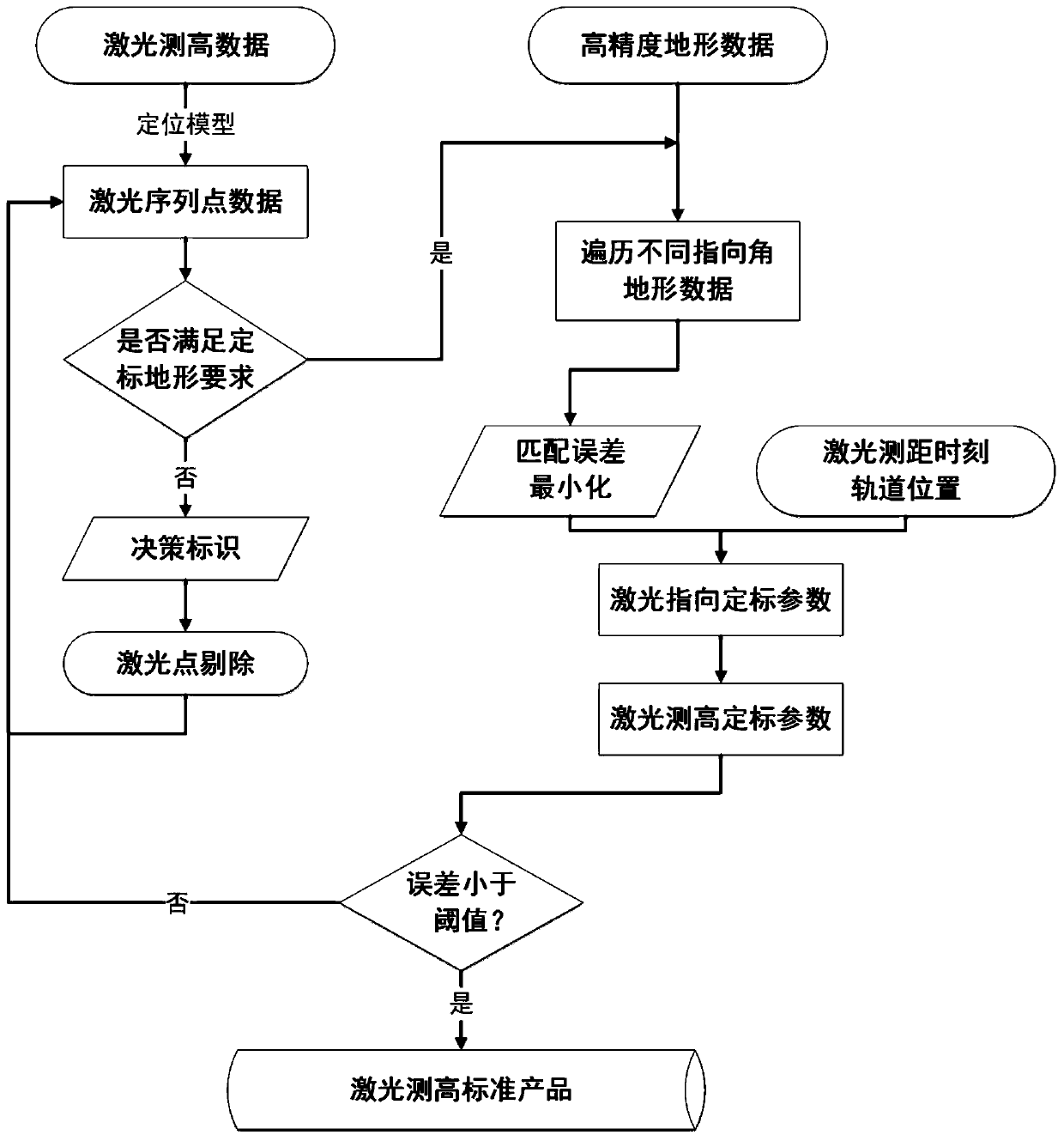
[0108] This embodiment provides a spaceborne laser geometric calibration method based on terrain constraints, see attached image 3 .

[0109] The basic principle of geometric calibration of the laser altimeter is as follows: Assume that the position of the satellite laser is S, the laser emits a signal to point A on the surface, and SA is the actual pointing and distance of the laser ranging. The laser calculation path becomes SA', which will cause the model error Δh in the direction of laser ranging, which will cause errors in the elevation of footprints obtained by the laser altimetry positioning model.

[0110] Then, based on the rigorous geometric positioning model of the spaceborne laser, the geometric calibration model of laser altimetry can be constructed, as follows:

[0111]

[0112] In formula (13), t is the error compensation amount of the laser ranging time, R(φ,ω) is the offset matrix related to the laser beam exit angle (φ,ω), where φ,ω represent the laser...


PUM


Abstract

The invention discloses a field-free geometric calibration method and system for a satellite-borne laser altimeter. The method comprises the following steps of: (1) solving an initial positioning result of the laser altimeter based on a strict geometric positioning model, (2) compensating the propagation atmospheric delay time of the satellite-borne laser to a positioning result of the laser altimeter by using an atmospheric delay correction model, and (3) selecting a laser sequence point according to the height measurement positioning data, matching the elevation information of the laser footprint point in the laser sequence point with the known terrain, and calibrating the laser emitting direction based on the matching result. The invention provides a brand-new laser on-orbit geometric calibration method, and thus, the problem of inaccurate initial pointing of the satellite-borne laser altimeter is solved, the blank in the aspect in China is filled up, and a basis is provided for high-precision geometric processing of satellite-borne laser radar height measurement data.

Description

technical field [0001] The invention belongs to the field of aerospace photogrammetry, in particular to a field-free geometric calibration method and system for a spaceborne laser altimeter. Background technique [0002] The space-borne laser altimeter technology is to use the laser altimeter carried by the satellite to emit pulse signals and record the laser echo data reflected by the ground to realize the determination of the surface elevation information. At first, this technology was mainly used in deep space exploration, such as the laser altimeter in the Clementine lunar exploration in the United States, the MOLA of NASA's Mars probe, the NLR on the NEAR probe, and the LAM altimeter of my country's Chang'e-1 (CE-1), etc. . The ICESat satellite launched by the United States in 2003 was equipped with the Earth Science Laser Altimeter System (GLAS), and spaceborne laser altimetry technology has gradually become a research hotspot. In May 2016, the ZY3-02 satellite (ZY3-0...

Claims


Application Information

Patent Timeline
IPC IPC(8): G01C25/00
CPCG01C25/00
Inventor 张过李少宁陈新阳
Owner WUHAN UNIV
Why Eureka
Try Eureka