Rotor unmanned aerial vehicle repositioning photographing method for electric power tower inspection

A technology of unmanned rotor and electric pole tower, which is applied in non-electric variable control, three-dimensional position/channel control, vehicle position/route/height control, etc., which can solve the problems of heavy work, reducing the efficiency of patrol inspection, and boring manual calibration work. , to reduce workload and improve efficiency

Pending Publication Date: 2020-05-08
CHINA JILIANG UNIV
View PDF5 Cites 7 Cited by
  • Summary
  • Abstract
  • Description
  • Claims
  • Application Information

AI Technical Summary

Problems solved by technology

However, the manual calibration work is boring and he...

Method used


Image

  • Rotor unmanned aerial vehicle repositioning photographing method for electric power tower inspection
  • Rotor unmanned aerial vehicle repositioning photographing method for electric power tower inspection
  • Rotor unmanned aerial vehicle repositioning photographing method for electric power tower inspection

Examples


Embodiment Construction

[0037] The present invention will be further described below in conjunction with the accompanying drawings.

[0038] Such as figure 1 , 4 As shown, a method for repositioning and taking pictures of a rotor UAV for inspection of power poles and towers, including a rotor UAV 1, a camera 3, a gimbal 5, a GPS positioning module 2, a data transmission and image transmission integrated transceiver module 4, and a ground Station image processing system 6 and hand-held wireless remote controller 7; The main control of the drone is a pixhawd flight control board; The system is a ground computer that saves photos and GPS information, processes feature point matching, and controls the flight of the drone; the handheld wireless remote controller is a ground handheld remote controller that is frequency-linked with the receiver on the flight controller.

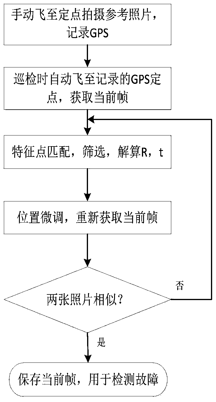
[0039] Such as figure 1 As shown, when a power pole tower is inspected at a fixed point, it is first necessary to read the GPS coordin...


PUM


Abstract

The invention discloses a rotor unmanned aerial vehicle repositioning photographing method for electric power tower inspection. The method comprises the following steps: flying to an electric power tower easy-to-fail point by using a rotor unmanned aerial vehicle carrying a camera to locate and shoot a reference picture, and recording GPS (Global Positioning System) information of the point; controlling the rotor unmanned aerial vehicle to fly to the easy-to-fail point by using the GPS coordinates of the reference picture during tower inspection to obtain a current frame; carrying out featurepoint matching on the shot reference picture and the current frame, and calculating a rotation amount and a translation amount of the rotor unmanned aerial vehicle at the current shooting position relative to the shooting position of the reference picture so as to control the unmanned aerial vehicle to adjust the attitude of the unmanned aerial vehicle finely to reach the reference picture position and eliminate GPS errors; and acquiring the current frame again after fine adjustment, carrying out similarity comparison with the reference picture shot for the first time, and storing the currentframe when the similarity requirement is met, thereby realizing repositioning shooting. According to the method, the shot picture is repositioned and the fault point of the power tower can be detecteddirectly through deep learning, so that the manual calibration work of the fault point in the picture is reduced, and the power tower inspection efficiency is improved.

Description

technical field [0001] The invention relates to the technical field of electric power inspection, in particular to a repositioning and photographing method of a rotor drone used for electric power tower inspection. Background technique [0002] my country's electric power enterprise is an important pillar industry in economic development, providing people with the necessary source of electric energy every year, and transmission lines are the main components of the power system. In recent years, the scale of the power grid has gradually expanded, and the number of power transmission lines has also increased, and some transmission lines are set in areas with complex terrain. Power poles and towers will be exposed to wind and sun, which will cause problems such as parts falling off and terminals loosening. [0003] Due to the harsh geographical environment and the difficulty of finding faults in power poles and towers, traditional manual inspections are increasingly unable to ...

Claims


Application Information

Patent Timeline
IPC IPC(8): G05D1/08G01C11/00G05D1/10
CPCG05D1/0808G05D1/101G01C11/00
Inventor 江亮郑恩辉陈锡爱徐红伟
Owner CHINA JILIANG UNIV
Why Eureka
Try Eureka