Method and system for classifying and expanding building points in airborne laser radar point cloud

An airborne lidar, building technology, applied in computer parts, character and pattern recognition, instruments, etc., can solve problems such as incomplete classification

Active Publication Date: 2020-06-26
飞燕航空遥感技术有限公司
View PDF4 Cites 2 Cited by
  • Summary
  • Abstract
  • Description
  • Claims
  • Application Information

AI Technical Summary

Problems solved by technology

[0005] Purpose of the invention: Aiming at the problem of incomplete classification of building points in the airborne LiDAR point cloud in the prior art, the present invention provides a method for classifying and expanding building points in the airborne LiDAR point cloud. Classified point reclassification

Method used


Image

  • Method and system for classifying and expanding building points in airborne laser radar point cloud
  • Method and system for classifying and expanding building points in airborne laser radar point cloud
  • Method and system for classifying and expanding building points in airborne laser radar point cloud

Examples


Embodiment Construction

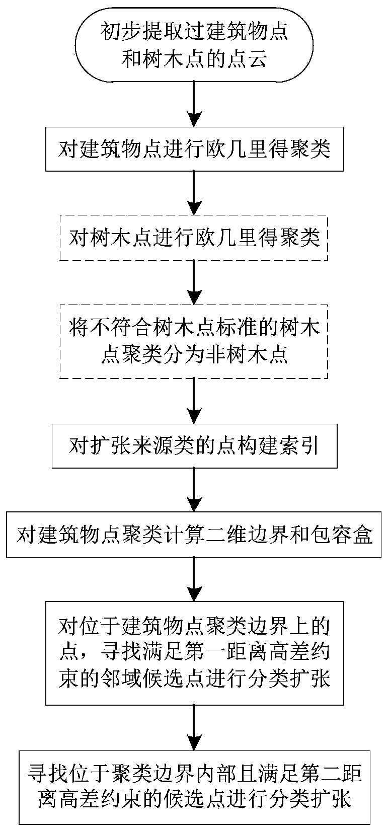
[0076] The present invention will be further explained below in conjunction with the accompanying drawings and specific embodiments.

[0077] like figure 1 As shown, the present invention discloses a method for classifying and expanding building points in an airborne lidar point cloud, including:

[0078] Step 1. Obtain the results of preliminary classification of airborne lidar point clouds in the survey area, the results include: building point cloud data C 1 , tree point cloud data C 2 , other types of point cloud data C 0 ;

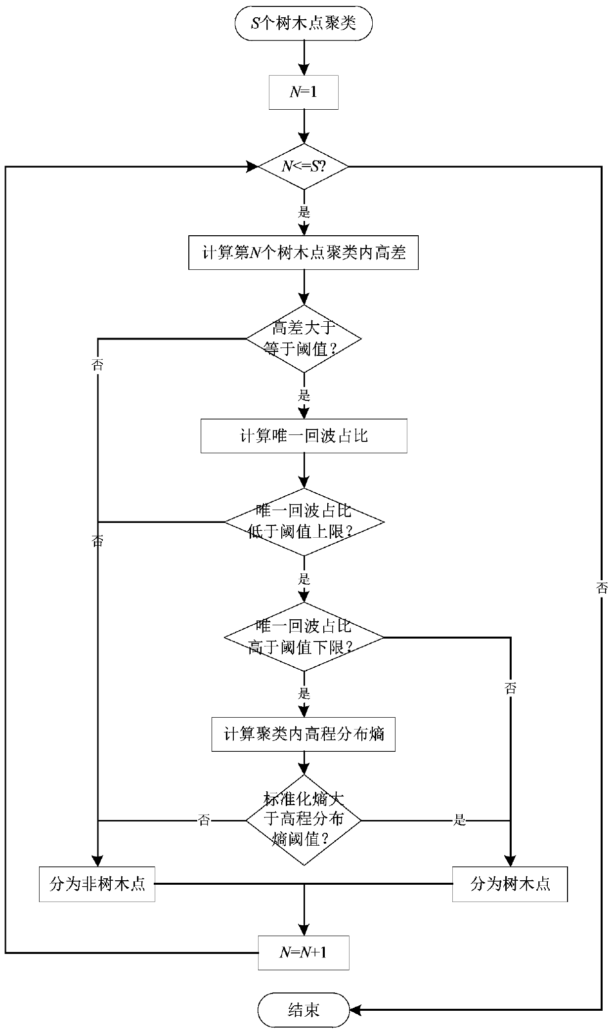
[0079] Step 2. Use three-dimensional Euclidean clustering to analyze the building point cloud data C 1 and tree point cloud data C 2 Clustering to get N 1 clustering of building points Non-building cluster point set P 1 , N 2 tree point clustering Non-tree clustering point set P 2 ;i=1,2,...,N 1 , j=1,2,...,N 2 ;

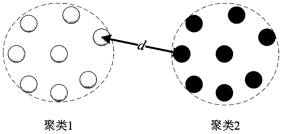
[0080] like figure 2As shown, the result of Euclidean clustering is to make the minimum distance d between different clu...


PUM


Abstract

The invention discloses a method and a system for classifying and expanding building points in airborne laser radar point cloud. The method for classifying and expanding the building points comprisesthe following steps of: 1, acquiring a preliminary classification result of the airborne laser radar point cloud in a measurement area; 2, clustering the building point cloud data C1 by adopting three-dimensional Euclidean clustering; 3, setting a building point expansion candidate point set; constructing an index for the building point expansion candidate point set; 4, respectively calculating aboundary and a space containing box of each building point cluster on an XY plane; 5, performing first-class classification expansion on N1 building point clusters in sequence; and 6, performing second-class classification expansion on N1 building point clusters in sequence. Aiming at the problem of incomplete classification of automatic classification of building points in airborne LiDAR point clouds in the prior art, points which are not classified successfully are classified again.

Description

technical field [0001] The invention belongs to the field of airborne laser radar point cloud data processing, and in particular relates to a method for classifying and expanding incompletely classified building points from the airborne laser radar point cloud, so as to make building point extraction more complete. Background technique [0002] Airborne LiDAR (Light Detection And Ranging, laser radar) is one of the most efficient and fastest-growing large-area surveying and mapping methods in the current surveying and mapping field. By using the laser to emit and receive high-energy laser pulses to measure distance, the GNSS (Global Navigation Satellite System, Global Navigation Satellite System) receiver gives the real-time position of the laser, and the INS (Inertial Navigation System, inertial navigation system) gives the real-time three-dimensional attitude of the laser. The three-dimensional coordinates of the scattering surface can be calculated by vector formula and c...

Claims


Application Information

Patent Timeline
Patent Type & Authority Applications(China)
IPC IPC(8): G06K9/62
CPCG06F18/23G06F18/24
Inventor 程晓光郑诚慧严明江芝娟赵梓言魏婧王秋艳白惠茹姚昌荣丛玉颖
Owner 飞燕航空遥感技术有限公司
Why Eureka
Try Eureka