
Method for extracting surface feature elements in topographic map

An extraction method and topographic map technology, applied in neural learning methods, biological neural network models, instruments, etc., can solve the problems of time efficiency not meeting data update, low degree of automation, manual interaction, and high operating costs.

Pending Publication Date: 2020-07-07
BEIJING GEO VISION TECH
View PDF0 Cites 0 Cited by
  • Summary
  • Abstract
  • Description
  • Claims
  • Application Information

AI Technical Summary

Problems solved by technology

[0002] The prominent contradictions in the production unit's years of topographic mapping work are the low degree of automation in all aspects of the operation and the need for frequent manual interaction operations. A large amount of manpower leads to low production efficiency and high operating costs.
Especially at present, the country is vigorously carrying out the construction of real scene 3D and global mapping projects. The scope of data processing has expanded from domestic to global, and the data content is more complex and finer. If it is completed by manpower alone, the investment will increase geometrically, and the time efficiency will also increase Far from meeting the needs of data update

Method used


Image

  • Method for extracting surface feature elements in topographic map
  • Method for extracting surface feature elements in topographic map
  • Method for extracting surface feature elements in topographic map

Examples


Embodiment Construction

[0043] In order to make the purpose, technical solutions and advantages of the embodiments of the present invention clearer, the technical solutions in the embodiments of the present invention will be clearly and completely described below in conjunction with the drawings in the embodiments of the present invention. Obviously, the described embodiments It is a part of embodiments of the present invention, but not all embodiments. Based on the embodiments of the present invention, all other embodiments obtained by persons of ordinary skill in the art without making creative efforts belong to the protection scope of the present invention.

[0044] Below in conjunction with accompanying drawing, the present invention is described in further detail:

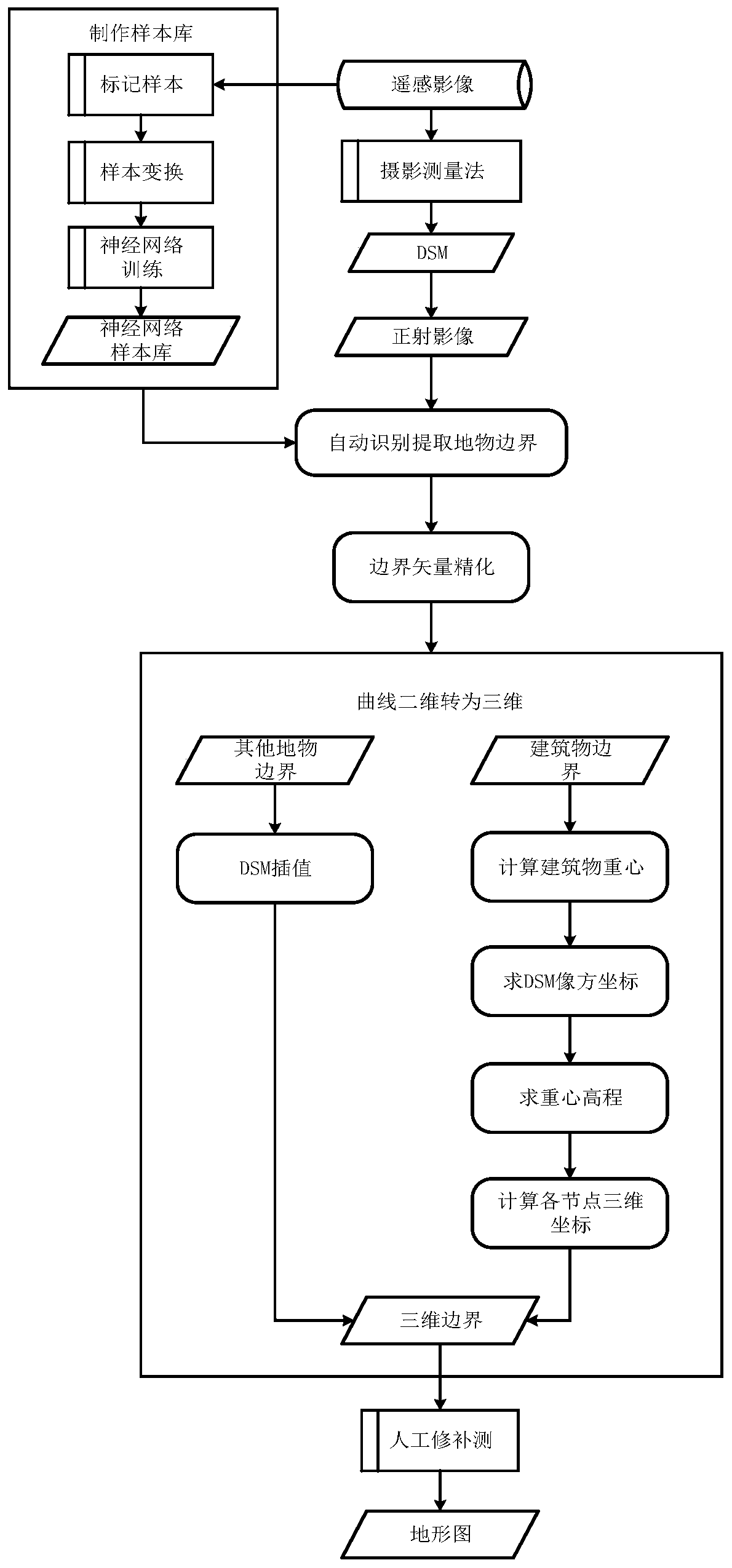
[0045] The invention provides a method for extracting feature elements in a topographic map, which is used for intelligently extracting the boundaries of feature elements from aerospace remote sensing images and forming a topographic...


PUM


Abstract

The invention discloses a method for extracting surface feature elements in a topographic map, which comprises the following steps of: generating an ortho-image and a DSM (Digital Subscriber Module) based on a remote sensing image; respectively making a sample library of each type of elements; matching different ground objects in the image through the trained neural network sample library of eachtype of element samples to obtain a ground object element planar region, detecting a surface and extracting a ground object boundary vector; matching the buildings on the original image, and matchingthe non-buildings on the orthoimage; refining the ground object boundary vector; converting the refined two-dimensional curve into a three-dimensional curve; converting building boundaries from a two-dimensional curve to a three-dimensional curve by adopting rational polynomial transformation or forward intersection, and non-building boundaries are converted from the two-dimensional curve to the three-dimensional curve by adopting a DSM interpolation algorithm; and processing the three-dimensional curve to obtain a topographic map. Manual links in topographic map production are reduced, and the geographic information data processing efficiency is greatly improved.

Description

technical field [0001] The invention relates to the technical field of geographic information extraction, in particular to a method for extracting feature elements in topographic maps. Background technique [0002] The prominent contradictions in the production unit's years of topographic mapping work are the low degree of automation in all aspects of the operation, frequent manual interaction operations, a large amount of manpower leading to low production efficiency and high operating costs. Especially at present, the country is vigorously carrying out the construction of real scene 3D and global mapping projects. The scope of data processing has expanded from domestic to global, and the data content is more complex and finer. If it is completed by manpower alone, the investment will increase geometrically, and the time efficiency will also increase It is far from meeting the needs of data updating. [0003] On the other hand, artificial intelligence technology is becomin...

Claims


Application Information

Patent Timeline
IPC IPC(8): G06K9/00G06K9/62G06N3/04G06N3/08
CPCG06N3/08G06V20/13G06N3/045G06F18/22G06F18/241
Inventor 张刚孟航王涛
Owner BEIJING GEO VISION TECH
Learn More