Underwater topography and sludge thickness survey system for riverway reservoir bank

A technology for underwater topography and survey systems, applied in radio wave measurement systems, measurement devices, water resource assessments, etc., can solve problems such as jumps and inability to effectively expand the width of sounding strips, to facilitate picking and improve basic scientific research Capabilities and business capabilities, effects of reducing jumps and uncertainties

Active Publication Date: 2020-08-25
YELLOW RIVER ENG CONSULTING
View PDF6 Cites 14 Cited by
  • Summary
  • Abstract
  • Description
  • Claims
  • Application Information

AI Technical Summary

Problems solved by technology

[0003] However, in the prior art, the observation capabilities of underwater topographic survey and sedimentation quantitative identification under normal and emergency conditions cannot meet the requirements. Underwater measurement is easily affected by multiple passages of underwater sound waves, and there are jumps and uncertainties in water depth measurement. , cannot effectively expand the width of the sounding strip

Method used


Image

  • Underwater topography and sludge thickness survey system for riverway reservoir bank
  • Underwater topography and sludge thickness survey system for riverway reservoir bank
  • Underwater topography and sludge thickness survey system for riverway reservoir bank

Examples


Embodiment Construction

[0024] Hereinafter, the present invention is described in more detail to facilitate understanding of the present invention.

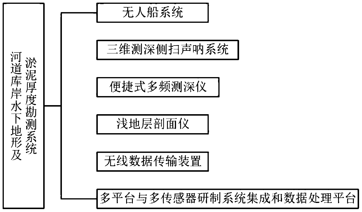
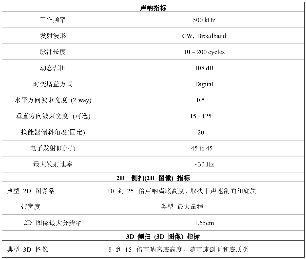
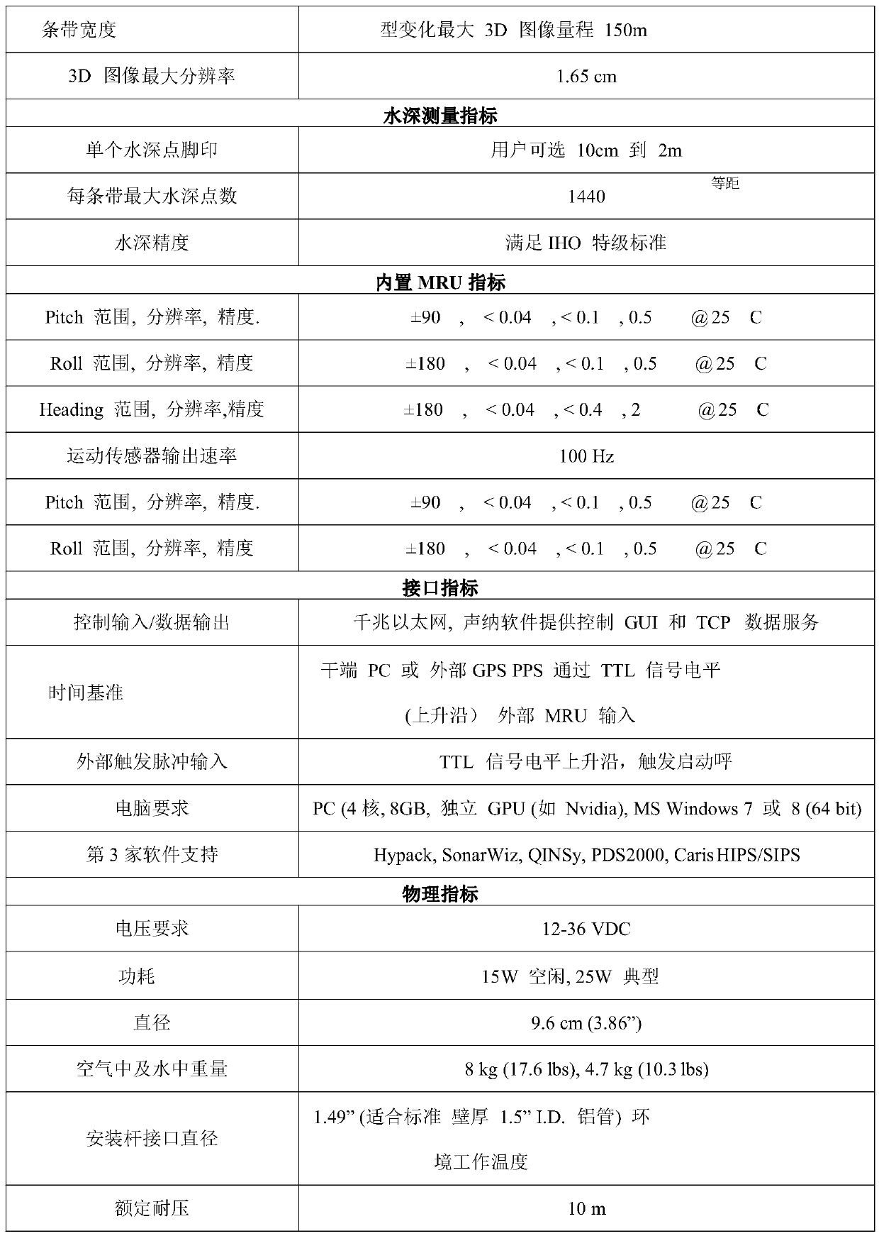
[0025] Such as figure 1 As shown, the underwater topography and silt thickness survey system of the river reservoir bank based on unmanned ship network observation according to the present invention includes an unmanned ship system, a three-dimensional sounding side-scan sonar system, a portable multi-frequency sounder, a shallow strata Profiler, wireless data transmission device, multi-platform and multi-sensor development system integration and data processing platform; said three-dimensional sounding side-scan sonar system, portable multi-frequency sounder, wireless data transmission device, and multi-platform and multi-sensor development Both system integration and data processing platforms are installed on the hull of the unmanned ship system; the 3D bathymetric side-scan sonar system is used to simultaneously obtain 2D sonar images, high-resoluti...


PUM


Abstract

The invention relates to a riverway reservoir bank underwater terrain and sludge thickness survey system. The system comprises an unmanned ship system, a three-dimensional sounding side-scan sonar system, a portable multi-frequency depth finder, a shallow stratum profiler, a ground profile instrument, a wireless data transmission device and a multi-platform and multi-sensor development system integration and data processing platform. The three-dimensional sounding side-scan sonar system is used for simultaneously obtaining a 2D sonar image, a high-resolution 3D side-scan image and strip sounding data in one-time measurement navigation; the portable multi-frequency depth finder is used for pipeline route investigation and sedimentation condition investigation; the shallow stratum profiler can measure water depth data and shallow profile data, and profile display is carried out on a water bottom stratum; the wireless data transmission device is suitable for carrier-grade point-to-point network application; and the multi-platform and multi-sensor development system integration and data processing platform is used for realizing transmission communication of real-time data and constructing an underwater topographic survey network of the heterogeneous unmanned ship.

Description

technical field [0001] The invention relates to the technical field of integrated rapid acquisition and intelligent processing of underwater information, in particular to a system for surveying underwater topography and silt thickness of banks of rivers and reservoirs based on unmanned vessel network observation. Background technique [0002] At present, four technical solutions are usually adopted for underwater terrain survey and silt thickness measurement: 1. Using dual-frequency GPS receiver plus dual-frequency digital depth sounder, dynamic real-time positioning (RTK) measurement mode combined by base station and rover station; 2. Using a GPS receiver plus a dual-frequency digital depth sounder, the real-time positioning measurement mode of pseudo-range difference combined by a base station and a rover; Pseudo-range differential post-processing measurement mode connected to running tracking stations; 4. Polar coordinate method automatic measurement mode using a combinat...

Claims


Application Information

Patent Timeline
Patent Type & Authority Applications(China)
IPC IPC(8): G01S15/89
CPCG01S15/8902Y02A90/30
Inventor 李清波雷添杰付健庞治国陈翠霞
Owner YELLOW RIVER ENG CONSULTING
Why Eureka
Try Eureka