Find position-based photo control point elevation precision cloud computing conversion method
A technology like control points and cloud computing, which is applied in complex mathematical operations, special data processing applications, structured data retrieval, etc., can solve the problems of time-consuming and labor-intensive, and Qianxun location service cannot directly obtain centimeter-level problems, so as to save costs The effect of training on construction period, ensuring safety and solution accuracy
- Summary
- Abstract
- Description
- Claims
- Application Information
AI Technical Summary
Problems solved by technology
Method used
Image
Examples
Embodiment 1
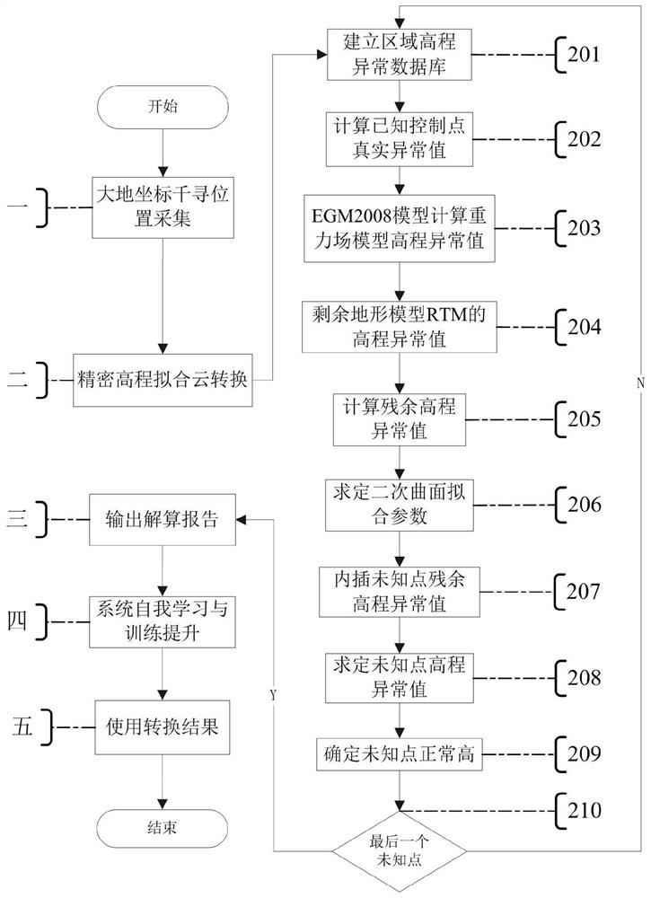
[0072] refer to figure 1 A conversion method based on Qianxun position's precise cloud computing of image control point elevation as shown, including the following steps
[0073] Step 1: Qianxun location collection with geodetic coordinates
[0074] Manual or automatic interface for geodetic coordinate Qianxun position collection;
[0075] Step 2: Perform precise elevation fitting cloud conversion
[0076] The geodetic coordinates of Qianxun's position collected in step 1 are converted to the cloud for precision elevation fitting on the private cloud computing platform, and the ellipsoidal height of the geodetic coordinates is converted into the normal height system of the surveying and mapping datum;
[0077] Step 3: Output the solution report
[0078] The private cloud platform server outputs the elevation cloud calculation conversion result obtained in step 2 as a calculation report, which includes calculation results, processing accuracy evaluation and graphic display; ...
Embodiment 2
[0088] refer to figure 1 The shown one is based on Qianxun position's image control point elevation precision cloud computing conversion method, which is different from Embodiment 1 in that: the coordinate collection in step 1 is to use Qianxun position mobile terminal to directly measure WGS84 ellipsoid Geodetic coordinate A under the sphere 1 (B,L,H),A 2 (B,L,H)...、A i (B,L,H);
[0089] Among them: A i (B, L, H) are the coordinates of the i-th row point, i=1, 2,....
[0090] Further, the geodetic coordinate Qianxun position collected in the step 1 adopts a fixed format of text:
[0091] A 1 (B,L,H)
[0092] A 2 (B,L,H)
[0093] ...
[0094] A i (B,L,H)
[0095] Coordinates of one point per line;
[0096] Among them: B, L are the latitude and longitude of the geodetic coordinates, unit: decimal degrees;
[0097] H is the height of the earth, unit: meter;
[0098] A i (B, L, H) are the coordinates of the i-th row point, i=1, 2,....
[0099] Further, the decima...
Embodiment 3
[0102] refer to figure 1 The shown a conversion method based on the precise cloud computing of the height of the image control point based on Qianxun's position is different from the first embodiment in that: the conversion of the precise height fitting cloud in the second step includes at least the following steps:
[0103] Step 201: Establish a regional elevation anomaly database composed of known control points; the known control points in the database are not more than 30km apart and evenly distributed, and at the same time obtain the high-precision geodetic height H of the WGS84 reference ellipsoid of these known control points wgs84 and normal high h 1985 .
[0104] Step 202: Calculate the real outlier ζ=H of known control points wgs84 -h 1985 ;
[0105] Step 203: Calculate the elevation outlier ζ of the gravity field model GM ;
[0106] Step 204: Calculate the height anomaly ζ of the remaining terrain model RTM RTM ;
[0107] Step 205: Calculate the abnormal val...
PUM
 Abstract
Description
Claims
Application Information
 - R&D
- Intellectual Property
- Life Sciences
- Materials
- Tech Scout
- Unparalleled Data Quality
- Higher Quality Content
- 60% Fewer Hallucinations
Browse by: Latest US Patents, China's latest patents, Technical Efficacy Thesaurus, Application Domain, Technology Topic, Popular Technical Reports.
© 2025 PatSnap. All rights reserved.Legal|Privacy policy|Modern Slavery Act Transparency Statement|Sitemap|About US| Contact US: help@patsnap.com

