Excavator intelligent high-precision positioning method based on satellite navigation

A positioning method and satellite navigation technology, applied in the comprehensive application field of satellite technology, can solve problems such as the inability to realize the automation of excavators, intelligent high-precision positioning, etc.

Pending Publication Date: 2020-09-18
WANBAO MINING
View PDF6 Cites 8 Cited by
  • Summary
  • Abstract
  • Description
  • Claims
  • Application Information

AI Technical Summary

Problems solved by technology

[0014] The technical problem to be solved by the present invention is how to provide an intelligent high-precision positioning method for excavators based on s

Method used


Image

  • Excavator intelligent high-precision positioning method based on satellite navigation
  • Excavator intelligent high-precision positioning method based on satellite navigation
  • Excavator intelligent high-precision positioning method based on satellite navigation

Examples


Embodiment Construction

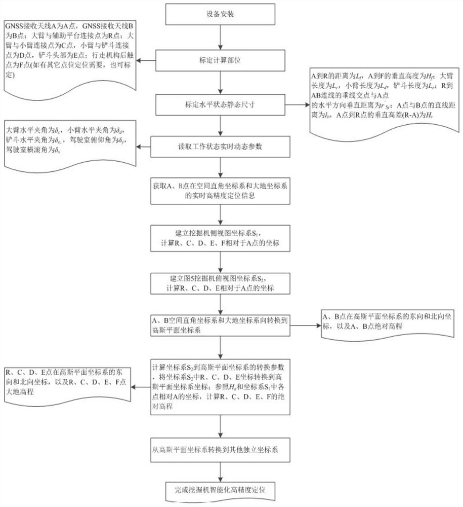
[0094] In order to make the purpose, content and advantages of the present invention clearer, the specific implementation manners of the present invention will be further described in detail below in conjunction with the accompanying drawings and embodiments.

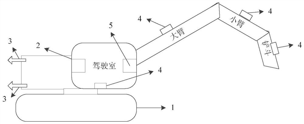
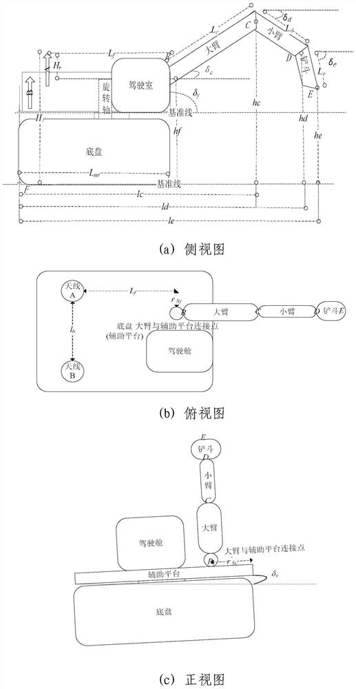
[0095] The present invention proposes an intelligent high-precision positioning system for excavators based on satellite navigation, which includes (attached figure 1 ): 1-excavator, 2-high-precision GNSS receiver, 3-GNSS receiving antenna, 4-tilt sensor, 5-vehicle computer. The high-precision GNSS receiver, GNSS receiving antenna, inclination sensor, and on-board computer are all installed on the excavator; the on-board computer is installed in the cab of the excavator, connected with the inclination sensor and high-precision receiver, and equipped with a dedicated positioning calculation software module; GNSS The receiving antenna is installed at the tail of the excavator and connected to the high-precision GNSS recei...


PUM


Abstract

The invention relates to an excavator intelligent high-precision positioning method based on satellite navigation, belongs to the field of satellite technology comprehensive application, and aims to solve the problem that in the prior art, automatic, intelligent and high-precision positioning of an excavator cannot be achieved. A receiver, a measurement type antenna, a single-axis angle sensor, adouble-axis angle sensor, a vehicle-mounted computer and other devices are installed on the excavator. The accurate positions of the excavator and main parts of the excavator can be solved through a Beidou high-precision space information technology and an analysis algorithm, the relative coordinates of all points under the operation posture of the excavator are reasonably analyzed and solved by constructing side-looking and top-looking two-dimensional coordinates, and accurate positioning of all the main parts can be completed through coordinate system conversion. On the basis of accurate positioning, rapid positioning can be achieved, the positioning precision is improved, automatic guiding and tracking of the excavator are completed, and the engineering application requirements of different industries are met.

Description

technical field [0001] The invention belongs to the field of comprehensive application of satellite technology, in particular to an intelligent high-precision positioning method for excavators based on satellite navigation. Background technique [0002] High-precision positioning, navigation and timing services based on the Global Navigation Satellite System (GNSS) have been widely used in various industries of the national economy such as agriculture, transportation, energy, and electric power. Among them, the coordinate system is the basis of the positioning description: [0003] Space Cartesian coordinate system: the origin of the coordinates is located at the center of the reference ellipsoid, the Z axis points to the north pole of the reference ellipsoid, the X axis points to the intersection point between the starting meridian plane and the equator, and the Y axis is located on the equator plane, tangent to the X axis with a right-handed system at an angle of 90 degree...

Claims


Application Information

Patent Timeline
IPC IPC(8): G01S19/42
CPCG01S19/42
Inventor 杜素忠张录彬张宇鹏周碧辉魏志高易国鹏
Owner WANBAO MINING
Why Eureka
Try Eureka