Land utilization classification rule set and water and soil loss monitoring method and system

A land and rule technology, applied in the field of land use classification rule sets, can solve the problems of inversion of vegetation coverage, insufficient use of UAV height information, labor cost and time cost, etc., to achieve automatic monitoring and reduce labor costs. The effect of cost and time cost

Pending Publication Date: 2020-09-25
POWERCHINA HUADONG ENG COPORATION LTD
View PDF7 Cites 4 Cited by
  • Summary
  • Abstract
  • Description
  • Claims
  • Application Information

AI Technical Summary

Problems solved by technology

[0004] The object-oriented method has incomparable potential in the land use classification of high-resolution remote sensing images. In the past, the land use classification of aerial images mostly used the characteristics of image spectrum, texture and shape, and did not make full use of the height information obtained by drones. Good to classify buildings, vegetation, waters and other features whose elevations are different from those of adjacent categories more accurately
[0005] At the same time, since the aerial images captured by UAVs only have RGB three-band data, the traditional NDVI index cannot be used to invert vegetation coverage. In the past, most engineering applications relied on the high-resolution features of UAV images. , judging the coverage of forest and grass vegetation empirically takes a lot of manpower and time

Method used


Image

  • Land utilization classification rule set and water and soil loss monitoring method and system
  • Land utilization classification rule set and water and soil loss monitoring method and system
  • Land utilization classification rule set and water and soil loss monitoring method and system

Examples


Embodiment Construction

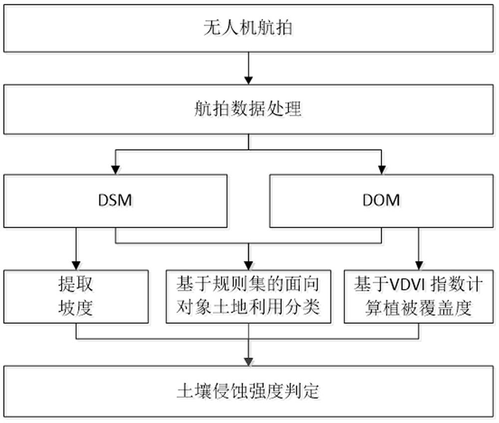
[0041] This embodiment provides a soil erosion monitoring method, the specific steps are as follows:

[0042] S0. Obtain the aerial image data of the monitored ground; use the UAV low-altitude aircraft as the remote sensing platform, integrate digital cameras, differential GPS and gyro platforms, and use digital photography technology to obtain aerial image data.

[0043] S1. Generate DOM and DSM based on aerial image data; digital orthophoto map DOM and digital surface model DSM are obtained from aerial image data through image data inspection, image data splicing, registration, and cropping.

[0044] Through Pix4D, ContextCapture and other software, operations including image stitching, aerial three encryption, and coordinate conversion are performed on UAV images to generate DOM; based on the dense cloud points obtained by UAVs, DSM is generated.

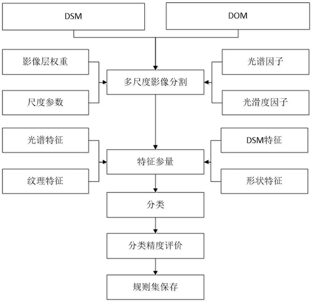
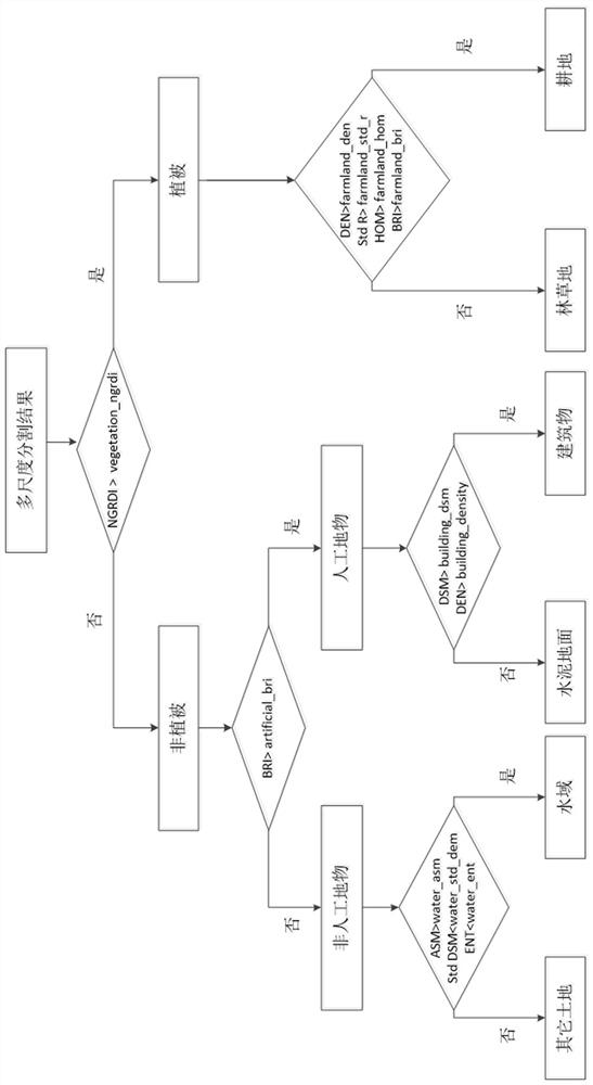
[0045] S2. Segment the DOM based on multi-scale segmentation; set the weight of each layer, spectral factor, smoothness factor,...


PUM


Abstract

The invention relates to a land utilization classification rule set and a water and soil loss monitoring method and system. The invention aims to provide a land utilization classification rule set anda water and soil loss monitoring method and system. According to the technical scheme, the land utilization classification rule set is characterized by comprising the steps that S1, a DOM and a DSM are generated according to aerial image data; S2, the DOM is segmented based on multi-scale segmentation; S3, the land utilization classification is carried out based on the spectrum, shape and texturefeatures of the aerial image data and the terrain height features provided by the DSM, and the current land utilization situation is obtained. The method is suitable for the technical field of waterand soil loss monitoring, and is especially suitable for monitoring the surface erosion situation in hydraulic erosion.

Description

technical field [0001] The invention relates to a land use classification rule set, a soil erosion monitoring method and a system. It is suitable for the technical field of water and soil loss monitoring, especially for monitoring surface erosion in hydraulic erosion. Background technique [0002] Water and soil loss is a major environmental problem in my country. Water and soil loss and the resulting land degradation and sediment problems not only have a serious impact on local ecology, environment, human survival and social and economic development, but also have serious impacts on adjacent areas. harm. Remote sensing monitoring of water and soil loss can find out the type, intensity and distribution characteristics of water and soil loss in a high-frequency, fast and large-scale manner, which is of great importance for the comprehensive control of water and soil loss and the macro-decision-making of ecological environment construction, as well as the scientific, reasonabl...

Claims


Application Information

Patent Timeline
Patent Type & Authority Applications(China)
IPC IPC(8): G01N21/25G06T7/10G06K9/62
CPCG01N21/25G06T7/10G01N2021/1765G01N2021/1797G06T2207/10032G06T2207/30188G06F18/2431
Inventor 陈妮李健应丰王静
Owner POWERCHINA HUADONG ENG COPORATION LTD
Why Eureka
Try Eureka