Hilly area citrus planting plot monitoring method and system based on remote sensing images

A technology of remote sensing images and area citrus, which is applied in the direction of instruments, character and pattern recognition, computer components, etc., can solve problems such as insufficient segmentation, deviation between calculated area and actual area, and difficulty in high-quality images, so as to improve accuracy and objectiveness performance, narrowing the scope of the study area, and high accuracy of classification results

Active Publication Date: 2020-09-25
GUANGXI ZHUANG AUTONOMOUS REGION ACAD OF AGRI SCI
View PDF10 Cites 27 Cited by
  • Summary
  • Abstract
  • Description
  • Claims
  • Application Information

AI Technical Summary

Problems solved by technology

[0005] The disadvantages of the existing technology are: (1) The existing technology mostly uses high-resolution images of one phase or multi-temporal medium-low resolution images as data sources to carry out crop information extraction, and there are few inventions in the collaborative application of medium-high-resolution images to extract crop information
Most studies use high-quality images with no cloud coverage, and the data of thick and large cloud coverage are ignored. However, high-quality images in cloudy and rainy areas are difficult to cover the entire research area. identify
(2) The existing technology uses segmentation methods (threshold-based segmentation, region-based segmentation, edge-based segmentation, etc.) to form parcel objects, which are prone to under-segmentation and over-segmentation. Object segmentation and modification take a long time, and it is difficult to guarantee Integrity of parcel objects with the same properties
(3) The existing technology is based on commonly used image features (NDVI, NDWI, RVI, etc.), using a classification method (support vector machine, decision tree, random forest, etc.) or threshold method to extract crop information, in areas with complex planting structures The classification accuracy cannot meet the requirements of use
(4) In the prior art, the crop information extraction area is calculated using the projected area for statistics, without considering the terrain fluctuations, and there is a deviation between the calculated area and the actual area
(5) Although the existing technology has achieved certain results in the extraction and invention of rice, sugarcane, mangrove, tea tree, cotton, etc., it is difficult to extract citrus planting information in cloudy and rainy hilly areas, and the error is huge

Method used


Image

  • Hilly area citrus planting plot monitoring method and system based on remote sensing images
  • Hilly area citrus planting plot monitoring method and system based on remote sensing images
  • Hilly area citrus planting plot monitoring method and system based on remote sensing images

Examples


Embodiment 2

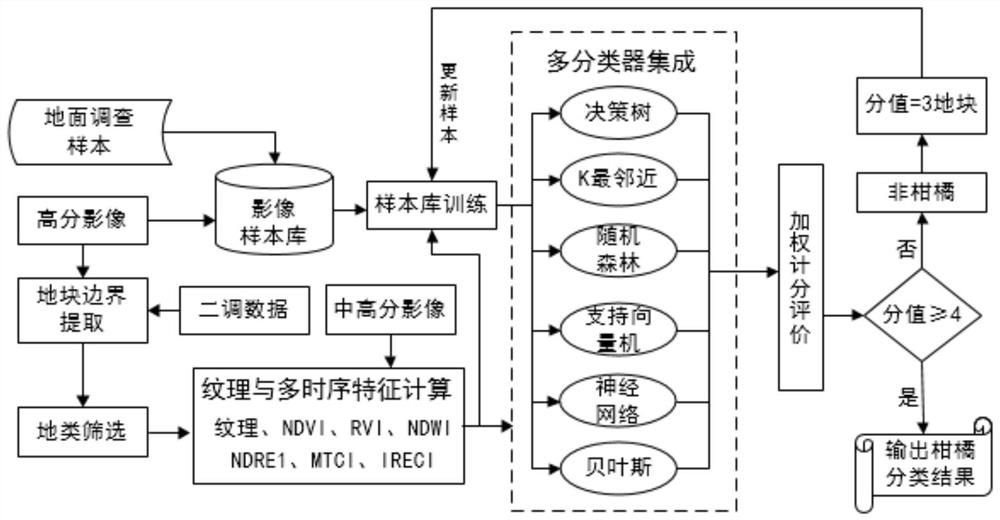
[0062] The present invention also provides a monitoring system for citrus planting plots in hilly areas based on remote sensing images, which includes:

[0063] An image acquisition module, which is used to obtain remote sensing mid-score images and high-score image information of the area to be monitored, and preprocess the images to obtain high-quality images;

[0064] The block sample extraction module is used to obtain the interpretation mark points including multiple different types of citrus by using 3S technology to collect and interpret marks on the spot in the monitoring area, and obtain training samples and verification samples;

[0065] The plot boundary extraction module uses the high-resolution image as the base, and superimposes the second tone data to obtain complete and accurate plots by including cutting, merging, and topology monitoring;

[0066] The feature calculation module is used to calculate the multi-temporal image features NDVI, RVI, NDWI, NDRE1, MTCI...


PUM


Abstract

The invention belongs to the technical field of agricultural information management, and particularly relates to a hilly area citrus planting plot monitoring method and system based on a remote sensing image, and the method comprises the steps: S1, obtaining remote sensing mid-resolution image and high-resolution image information of a to-be-monitored region, and carrying out the preprocessing ofan image; S2, collecting interpretation marks of the to-be-monitored region on site to obtain a training sample and a verification sample; S3, taking the high-resolution image as a substrate, and superposing two-tone data to update the morphological boundary of the plot; S4, calculating characteristic indexes of the multi-temporal image and the high-resolution image of the middle-resolution image;S5, taking the plot information obtained in the S2 as a training sample, and training a classifier based on the feature index in the S4; S6, inputting the image of the to-be-monitored region into a classifier for identification, and respectively outputting results; and S7, performing analysis through adoption of an equal-weight scoring method, and judging the citrus as citrus information if the score exceeds half. According to the invention, the accuracy and objectivity of crop identification in the prior art are improved.

Description

technical field [0001] The invention belongs to the technical field of agricultural information management, and in particular relates to a monitoring method and system for citrus planting plots in hilly areas based on remote sensing images. Background technique [0002] Guangxi is the province with the largest planting area and output of citrus in my country. The output has surpassed that of the United States. In 2017, the output was nearly 7 million tons, with an output value of more than 20 billion yuan. An important industry for getting rich. According to statistics, in 2018, the citrus planting area in Guangxi was about 7.52 million mu, with an output of 8.36 million tons, accounting for 46.7% of the total fruit in the region. Experts predict that the citrus planting area will exceed 10 million mu by 2020, and the citrus industry in Guangxi is growing rapidly In the development period, however, factors such as inaccurate information on citrus planting, blind expansion of...

Claims


Application Information

Patent Timeline
Patent Type & Authority Applications(China)
IPC IPC(8): G06K9/00G06K9/34G06K9/62
CPCG06V20/188G06V10/267G06F18/214Y02A40/10
Inventor 谢国雪黄启厅杨绍锷覃泽林曾志康苏秋群张秀龙马灿达张家玫林垚君
Owner GUANGXI ZHUANG AUTONOMOUS REGION ACAD OF AGRI SCI
Why Eureka
Try Eureka