Gridding rice sheath blight habitat evaluation method integrating multi-source remote sensing information

A technology of rice sheath blight and evaluation method, which is applied in the direction of instruments, character and pattern recognition, computer components, etc., can solve the problems of extensive and inability to provide continuous surface shape prediction results, reduce the amount of pesticides, and improve the efficiency of prevention and control , the effect of controlling the epidemic of diseases

Pending Publication Date: 2020-10-02
HANGZHOU DIANZI UNIV
View PDF8 Cites 5 Cited by
  • Summary
  • Abstract
  • Description
  • Claims
  • Application Information

AI Technical Summary

Problems solved by technology

At present, the prediction of diseases and insect pests is mainly based on point meteorological data, but the occurrence and development of crop diseases are closely related to different farmland environments and vegetation nutritional status. Therefore, forecasting only by meteorological data is relatively extensive and cannot provide continuous area prediction results.

Method used


Image

  • Gridding rice sheath blight habitat evaluation method integrating multi-source remote sensing information
  • Gridding rice sheath blight habitat evaluation method integrating multi-source remote sensing information
  • Gridding rice sheath blight habitat evaluation method integrating multi-source remote sensing information

Examples


Embodiment Construction

[0041] The present invention will be further described below in conjunction with accompanying drawing.

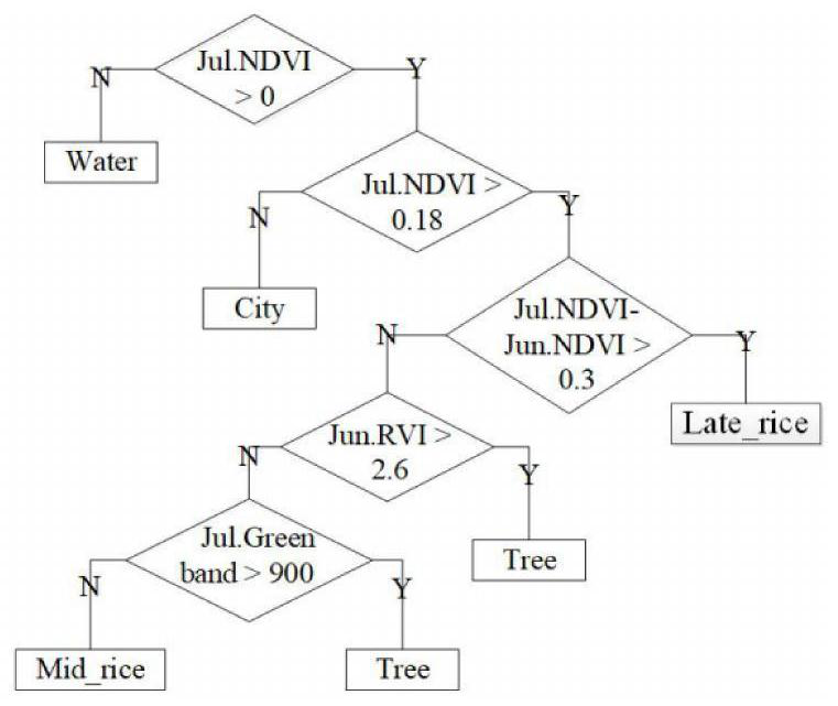
[0042] like figure 1 As shown, the gridded rice sheath blight habitat assessment method integrated with multi-source remote sensing information is as follows:

[0043] Step 1. Select the survey grid and obtain its multi-source remote sensing data and investigate its disease severity to establish a model.

[0044] 1-1. Select survey grid and conduct ground survey of disease severity

[0045] Select n survey grids in the tested rice field, n≥20. The size of the survey grid is 500m×500m. 4-7 sampling points were randomly selected in each survey grid. The sample point is the rice continuous planting area with an area not less than 15m×15m.

[0046] 1-2. Obtain the multi-source remote sensing data acquisition and preprocessing of the survey grid

[0047] Since the occurrence of rice diseases is related to the growth state of vegetation, the type of rice cultivation, the st...


PUM


Abstract

The invention discloses a gridding rice sheath blight habitat evaluation method integrating multi-source remote sensing information. Prediction only depends on punctiform meteorological data and is relatively extensive, and a continuous planar prediction result cannot be provided. The method comprises the following steps: 1, selecting an investigation area, acquiring multi-source remote sensing data of the investigation area and investigating disease severity of the investigation area; 2, determining the position and area of late rice; and 3, extracting rice sheath blight habitat characteristics based on the multi-source remote sensing image. And 4, establishing a disease habitat suitability model. And 5, gridding the measured field, and extracting the remote sensing habitat characteristics of the rice sheath blight disease. And 6, masking each remote sensing habitat feature by using the late rice classification map to obtain each remote sensing habitat factor feature of the late rice.And 7, acquiring the disease habitat suitability degree corresponding to each grid according to the model. And 8, obtaining a disease habitat suitability spatial distribution map. Through investigation and research analysis, most of soil-borne diseases are found to be related to habitat conditions such as host plant growth state and farmland environment.

Description

technical field [0001] The invention belongs to the field of analysis and processing of multi-source satellite remote sensing data and agronomy technology, and in particular relates to a method for assessing rice sheath blight habitat with space grid and integrating multi-source remote sensing information. Background technique [0002] Crop diseases are an important reason for the reduction of grain production in my country and even in the world. With global climate change, the frequency of disease occurrence has been increasing in recent years, posing a serious threat to my country's food security. Therefore, the effective prediction of the occurrence and spread of diseases can play a positive guiding role in the prevention and control work, and reduce the amount of pesticides, which is of great significance to my country's grain production. At present, the prediction of diseases and insect pests is mainly based on point meteorological data, but the occurrence and developm...

Claims


Application Information

Patent Timeline
Patent Type & Authority Applications(China)
IPC IPC(8): G06K9/00
CPCG06V20/188
Inventor 张竞成田洋洋张静文沈艳艳陈冬梅黄然周贤锋吴开华
Owner HANGZHOU DIANZI UNIV
Why Eureka
Try Eureka