
Method for quickly obtaining field map according to surf-scan

A map and fast technology, applied in the field of disaster site map survey, can solve the problems of high cost, high professional requirements of operators, and inability to quickly obtain maps, etc., and achieve the effect of simple operation and low cost

Inactive Publication Date: 2020-11-17
湖南大狗科技有限公司
View PDF3 Cites 1 Cited by
  • Summary
  • Abstract
  • Description
  • Claims
  • Application Information

AI Technical Summary

Problems solved by technology

[0002] Traditional accident and disaster sites cannot quickly obtain a complete map of the site. Generally, manual surveying and mapping, high-altitude aerial photography, satellite remote sensing and other methods can be used to obtain the site map after the disaster. The common points of these methods are time-consuming and professional operators. High requirements and high cost

Method used


Image

  • Method for quickly obtaining field map according to surf-scan
  • Method for quickly obtaining field map according to surf-scan
  • Method for quickly obtaining field map according to surf-scan

Examples


Embodiment Construction

[0028] The following will clearly and completely describe the technical solutions in the embodiments of the present invention with reference to the accompanying drawings in the embodiments of the present invention. Obviously, the described embodiments are only some, not all, embodiments of the present invention. Based on the embodiments of the present invention, all other embodiments obtained by persons of ordinary skill in the art without creative efforts fall within the protection scope of the present invention.

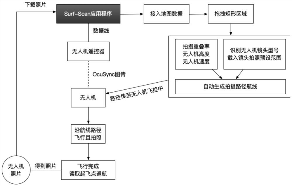
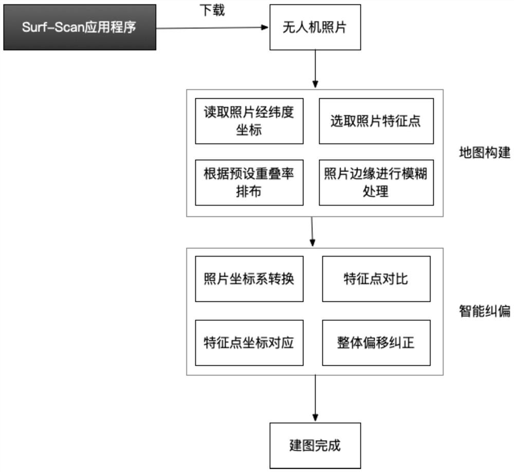
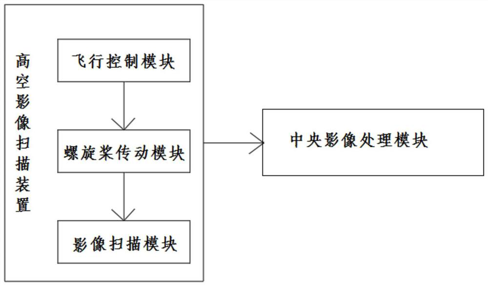
[0029] Such as Figure 1-3 As shown, the present invention is a system for quickly obtaining a site map according to surf-scan, including a high-altitude image scanning device, an information transmission module and a central image processing module;

[0030] The high-altitude image scanning device includes: aircraft control module, propeller drive module, and image scanning module. The flight control module is used to drive the high-altitude movement of the image ...


PUM


Abstract

The invention relates to a system and method for quickly obtaining a field map according to surfscan, and the system is characterized in that the system comprises a high-altitude image scanning device, an information transmission module, and a central image processing module, and the high-altitude image scanning device comprises an aircraft control module, a propeller transmission module, and an image scanning module; the flight control module is used for driving the image scanning module to move at a high altitude, transmitting the image scanning module to equipment with a central image module through the information transmission module, carrying out algorithm comparison on feature points of collected images, and carrying out splicing processing on the images in combination with GPS information. Compared with other surveying and mapping and map-generating equipment, Surf-Scan only needs one tablet personal computer and one unmanned aerial vehicle to complete map splicing work, carrying of an emergency site is facilitated. According to different areas of a reconstructed map, the shooting time is about 10-15 minutes, the map generation time is 2-5 minutes, and in other words, the map of the site can be completely obtained within half an hour.

Description

technical field [0001] The invention relates to the field of disaster site map survey, in particular to a method for rapidly obtaining a site map according to surf-scan. Background technique [0002] Traditional accident and disaster sites cannot quickly obtain a complete map of the site. Generally, manual surveying and mapping, high-altitude aerial photography, satellite remote sensing and other methods can be used to obtain the site map after the disaster. The common points of these methods are time-consuming and professional operators. High requirements and high costs. [0003] In the case of natural disasters, sudden accidents, etc., there is often not so much time, and it is also very important to obtain the on-site map, so it is very important to be able to quickly and conveniently obtain the on-site map data. Contents of the invention [0004] The purpose of the present invention is to overcome the above-mentioned problems existing in the prior art, and provide a m...

Claims


Application Information

Patent Timeline
Patent Type & Authority Applications(China)
IPC IPC(8): G01C11/00G01C11/02G01C21/20G01S19/42B64C39/02
CPCG01C11/00G01C11/02G01S19/42G01C21/20B64C39/024B64U2201/20B64U2101/30
Inventor 刘卓奇严磊段光明
Owner 湖南大狗科技有限公司
Learn More