Map boundary automatic extraction method and device based on terrain analysis

A map boundary, automatic extraction technology, applied in the direction of measurement device, electromagnetic wave re-radiation, navigation, etc., can solve the problems of error-prone, inconspicuous visual features, and heavy workload of secondary revision of map quality inspection, so as to improve efficiency. The effect of reducing complexity and increasing accuracy with precision

Active Publication Date: 2020-12-01
上海易澳科技有限公司
View PDF10 Cites 6 Cited by
  • Summary
  • Abstract
  • Description
  • Claims
  • Application Information

AI Technical Summary

Problems solved by technology

[0003] The production and update of high-precision maps for mines is currently mainly done by manual drawing; the boundary of high-precision maps for open-pit mines is mainly composed of hillsides and retaining walls, and the visual features are not obvious. Manual drawing is heavy and error-prone, resulting in The workload of map quality inspection and second

Method used


Image

  • Map boundary automatic extraction method and device based on terrain analysis
  • Map boundary automatic extraction method and device based on terrain analysis
  • Map boundary automatic extraction method and device based on terrain analysis

Examples


Embodiment Construction

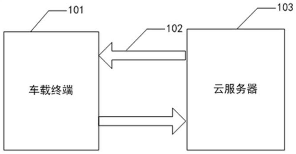
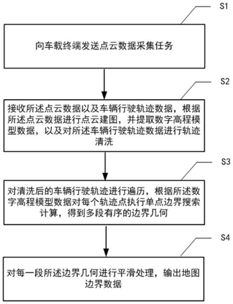
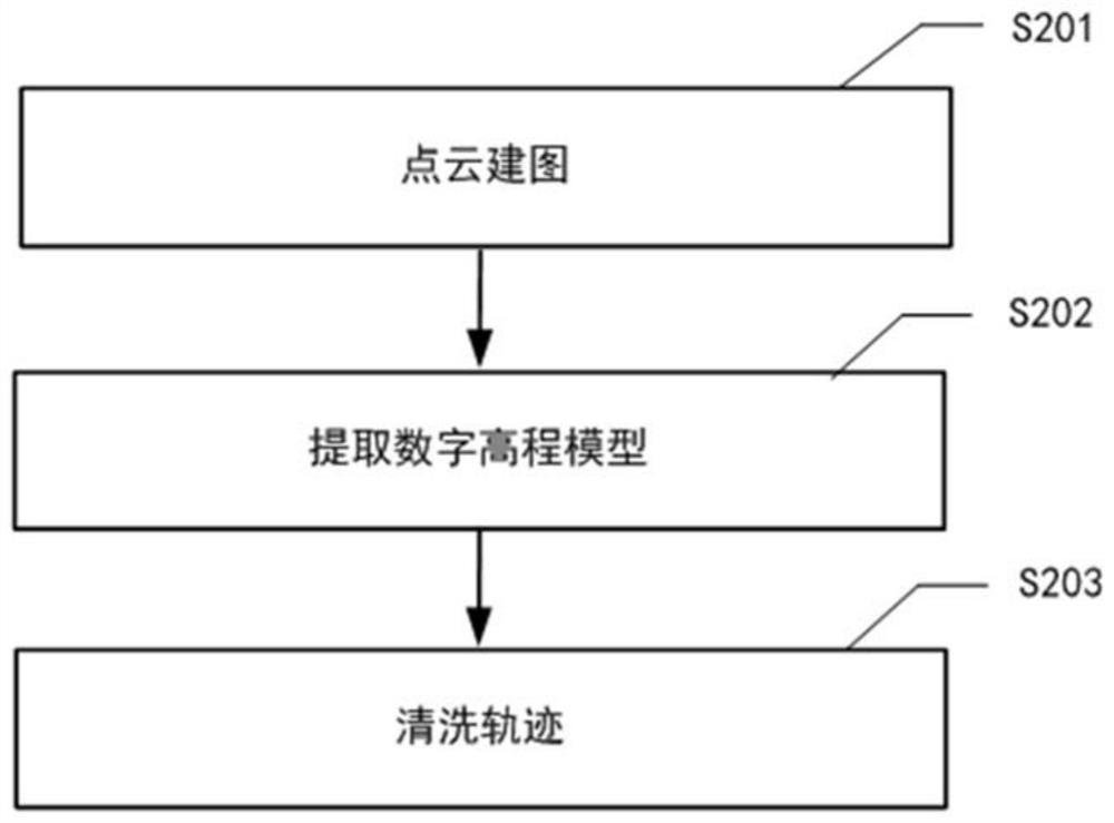
[0034] Hereinafter, embodiments of the present disclosure will be described with reference to the drawings. It should be understood, however, that these descriptions are exemplary only, and are not intended to limit the scope of the present disclosure. In the following detailed description, for purposes of explanation, numerous specific details are set forth in order to provide a thorough understanding of the embodiments of the present disclosure. It may be evident, however, that one or more embodiments may be practiced without these specific details. Also, in the following description, descriptions of well-known structures and techniques are omitted to avoid unnecessarily obscuring the concepts of the present disclosure.

[0035] The terminology used herein is for the purpose of describing particular embodiments only, and is not intended to be limiting of the present disclosure. The terms "comprising", "comprising", etc. used herein indicate the presence of stated features,...


PUM


Abstract

The invention provides a map boundary automatic extraction method based on terrain analysis. The method comprises the steps: sending a point cloud data acquisition task to a vehicle-mounted terminal,so that the vehicle-mounted terminal travels along a specified region to acquire point cloud data, and uploads the point cloud data and vehicle driving track data; receiving the point cloud data and the vehicle driving track data, performing point cloud mapping according to the point cloud data, extracting digital elevation model data, and performing track cleaning on the vehicle driving track data; traversing the cleaned vehicle driving track, and executing single-point boundary search calculation on each track point according to the digital elevation model data to obtain a plurality of sections of ordered boundary geometries; and carrying out smoothing processing on each section of boundary geometry, and outputting map boundary data. According to the invention, the terrain analysis algorithm is applied to the high-precision map boundary extraction process of the strip mine, and the map making efficiency and precision are effectively improved.

Description

technical field [0001] The present disclosure relates to the field of mining unmanned driving, and in particular to a method and device for automatically extracting map boundaries based on terrain analysis. Background technique [0002] Mine disasters are a serious problem in the development of resources all over the world. In the early years, limited by mining equipment, most of them used underground mining methods. Later, with the large-scale application of heavy machinery, open-pit mining methods gradually increased. Compared with underground mining, open-pit mining has higher mining efficiency and higher safety. With the accelerated development of industrial automation, the application of unmanned driving solutions in mining and transportation scenarios has become a current research hotspot in "smart mines". The operation site in the open-pit mining area is complex and changeable, and the boundaries of roads, loading areas, and dumps are changing in real time as the ope...

Claims


Application Information

Patent Timeline
IPC IPC(8): G01C21/00G01S17/89
CPCG01C21/005G01S17/89
Inventor 盛佳良张磊王方健王大伟李机智
Owner 上海易澳科技有限公司
Why Eureka
Try Eureka