Point cloud level fusion method of laser radar data and hyperspectral image

A hyperspectral image and lidar technology, applied in the field of multi-source remote sensing data fusion, can solve problems such as insufficient mining of point clouds and loss of effective information

Active Publication Date: 2020-12-25
GUANGDONG UNIV OF TECH
View PDF7 Cites 8 Cited by
  • Summary
  • Abstract
  • Description
  • Claims
  • Application Information

AI Technical Summary

Problems solved by technology

In fact, massive point cloud data contains rich spatial geometric structure information, and related research on feature-level fusion has failed to fully mine the information in point clouds.
In addition, image fusion based on low spatial resolution will lead to loss of effective information

Method used


Image

  • Point cloud level fusion method of laser radar data and hyperspectral image
  • Point cloud level fusion method of laser radar data and hyperspectral image
  • Point cloud level fusion method of laser radar data and hyperspectral image

Examples


Embodiment Construction

[0043] In order to enable those skilled in the art to better understand the solution of the application, the technical solution in the embodiment of the application will be clearly and completely described below in conjunction with the drawings in the embodiment of the application. Obviously, the described embodiment is only It is a part of the embodiments of this application, not all of them. Based on the embodiments in this application, all other embodiments obtained by persons of ordinary skill in the art without making creative efforts belong to the scope of protection of this application.

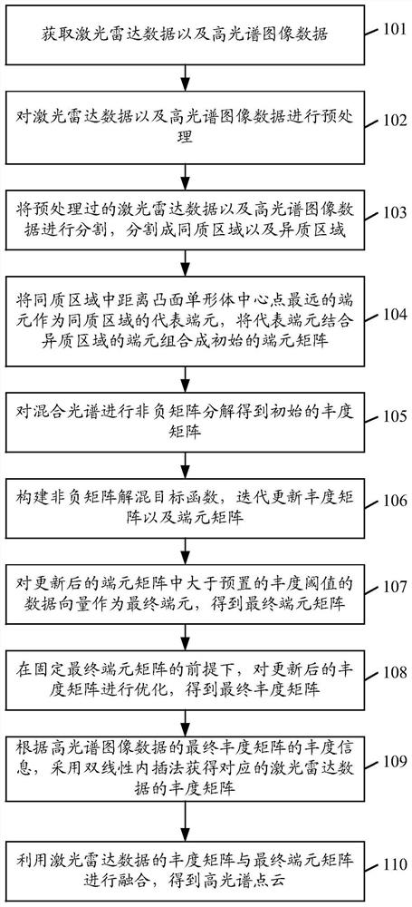
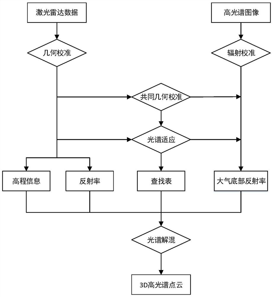
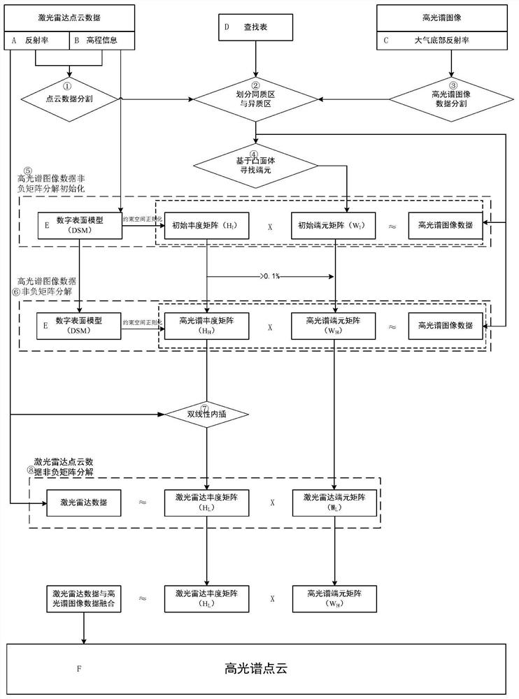
[0044] figure 1 A method flow chart of an embodiment of a point cloud level fusion method for lidar data and hyperspectral images of the present application, such as figure 1 as shown, figure 1 Including:

[0045] 101. Acquire lidar data and hyperspectral image spectral data.

[0046] It should be noted that in this application, it is necessary to install the coordinate origins of ...


PUM


Abstract

The invention discloses a point cloud level fusion method of laser radar data and a hyperspectral image. The method mainly aims at heterogeneous remote sensing data, namely the laser radar data and hyperspectral image data, and is characterized in that firstly unmixing is conducted on the hyperspectral data on the basis of a non-negative matrix decomposition framework added with regular terms to obtain a hyperspectral image data abundance matrix and an end member matrix; according to abundance information of a final abundance matrix of the hyperspectral image data, an abundance matrix of the laser radar data is obtained through a bilinear interpolation method; and finally the abundance matrix of the laser radar data is fused with a final hyperspectral end member matrix to obtain a hyperspectral point cloud. According to the method, the hyperspectral high-resolution spectral information and the small-spot laser radar elevation information are fused at the point cloud level, and the capabilities of carrying out spectral classification and 3D structure segmentation are achieved at the same time.

Description

technical field [0001] This application relates to the technical field of multi-source remote sensing data fusion, in particular to a point cloud-level fusion method of lidar data and hyperspectral images. Background technique [0002] The intelligentization of remote sensing earth observation and the demand for multi-directional and three-dimensional detection make the fusion of multi-source remote sensing data an unprecedented urgent demand. Especially in recent years, the fusion of elevation information from lidar scans and hyperspectral image data has provided a potential solution for such application requirements. [0003] Multi-source data fusion is usually divided into pixel-level fusion, feature-level fusion, and decision-level fusion. Pixel-level fusion is often used for image data with different spectral characteristics, such as the fusion of multispectral and panchromatic images, hyperspectral and multispectral images. However, lidar data and hyperspectral image...

Claims


Application Information

Patent Timeline
Patent Type & Authority Applications(China)
IPC IPC(8): G01S17/89G01S17/933
CPCG01S17/89G01S17/933
Inventor 赵艮平陈立宜王卓薇吴衡程良伦
Owner GUANGDONG UNIV OF TECH
Why Eureka
Try Eureka