Heterogeneous remote sensing image content-oriented digital elevation data reconstruction method

A digital elevation data and remote sensing image technology, applied in image data processing, kernel methods, 3D modeling, etc., can solve problems such as large differences, mountain tops below 0 degrees covered by ice and snow, data reconstruction failures, 3D reconstruction failures, etc.

Active Publication Date: 2021-02-09
CHANGCHUN INST OF TECH
View PDF5 Cites 0 Cited by
  • Summary
  • Abstract
  • Description
  • Claims
  • Application Information

AI Technical Summary

Problems solved by technology

[0003] In order to obtain fine surface digital elevation data, the current methods are divided into two categories: the first type is to obtain fine surface digital elevation data by means of manual measurement and aircraft laser radar measurement. The advantage of this method is that the data accuracy is high, but It requires a lot of financial and time support, and is more suitable for the acquisition of data in relatively developed urban areas. For large areas, most units cannot afford the corresponding financial and time requirements
The second type is to first download the low-resolution digital elevation information of the corresponding area as the basic three-dimensional data, find a small area for manual measurement to obtain fine elevation data, introduce high-resolution remote sensing images of the area, and use artificial intelligence algorithms to establish Based on the regression prediction model between high-resolution remote sensing images, low-resolution digital elevation, and high-resolution digital elevation information, the entire region is predicted; this method will be better applied in smal

Method used


Image

  • Heterogeneous remote sensing image content-oriented digital elevation data reconstruction method
  • Heterogeneous remote sensing image content-oriented digital elevation data reconstruction method
  • Heterogeneous remote sensing image content-oriented digital elevation data reconstruction method

Examples


Embodiment 1

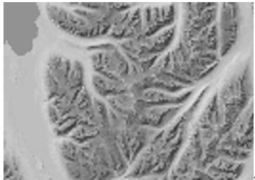
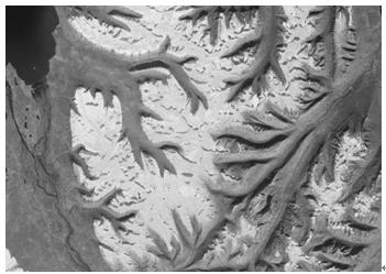
[0073] Taking the image and digital elevation of Greenland as an example, the method of the present invention is used to reconstruct and calculate the elevation data:

[0074] S1, facing a ground area, input the rough digital elevation data RoughDEM of this area, input the high-resolution remote sensing image Image of this area; input the rough digital elevation data RoughDEMSub1 of the first sub-area, and input the high-resolution of the corresponding range of RoughDEMSub1 Input the digital elevation data FineDEM1, input the high-resolution remote sensing image SubImage1 corresponding to the range of RoughDEMSub1; input the rough digital elevation data of the second sub-region RoughDEMSub2, input the high-resolution digital elevation data FineDEM2 of the corresponding range of RoughDEMSub2, input the high-resolution remote sensing image of the corresponding range of RoughDEMSub2 SubImage2. Obtain the number of elements Sub1Num of RoughDEMSub1, and obtain the number of element...

Embodiment 2

[0138] The present invention introduces the mountainous area in Northeast China as the test object, introduces 20 larger regions for testing, and compares the method described in the present invention with the traditional neural network method and support vector machine method. The results of the comparison are as follows:

[0139]

[0140] It can be seen from the table that in most areas, the error of the results obtained by the method described by the present invention is obviously lower than that of the other two traditional methods, which shows that the present invention can better carry out digital elevation data reconstruction work in larger areas.


PUM


Abstract

The invention provides a heterogeneous remote sensing image content-oriented digital elevation data reconstruction method, which comprises the following steps of establishing a remote sensing image content heterogeneous description operator, describing differences among remote sensing image contents based on the operator, and establishing a regression prediction model by utilizing the difference description and the characteristics of a remote sensing image, and large-area region digital elevation data reconstruction is realized. By means of the method, the regression prediction model can welladapt to heterogeneity between image contents, the model can obtain a good prediction result under the condition that the image contents have large difference, and large-area area digital elevation data reconstruction oriented to heterogeneous remote sensing image contents is achieved.

Description

Technical field: [0001] The present invention provides a digital elevation data reconstruction method for heterogeneous remote sensing image content, which is used for reconstructing and acquiring data in the field of geographic information systems, and specifically relates to the field of landform and surface remote sensing image technology. Background technique: [0002] Obtaining digital elevation data of large areas on the surface of the earth is helpful for large-scale geographic three-dimensional modeling, and is of great significance for the construction of basic geographic information data, virtual reality simulation, disaster simulation and prediction. Therefore, it is very necessary to obtain fine digital elevation data information of large areas of the surface. [0003] In order to obtain fine surface digital elevation data, the current methods are divided into two categories: the first type is to obtain fine surface digital elevation data by means of manual measu...

Claims


Application Information

Patent Timeline
IPC IPC(8): G06T17/05G06N20/10
CPCG06T17/05G06N20/10
Inventor 徐俊付浩海张华潘欣张敏
Owner CHANGCHUN INST OF TECH
Why Eureka
Try Eureka