2.5-dimensional spatial data visualization method based on GIS, medium and equipment
A technology of spatial data and dimensional space, applied in the field of space, can solve the problems of long time consuming of 3D models, high computer performance requirements, low precision, etc., and achieve the effect of fast browsing access, low software and hardware requirements, and fast reality speed.
- Summary
- Abstract
- Description
- Claims
- Application Information
AI Technical Summary
Problems solved by technology
Method used
Image
Examples
Embodiment 1
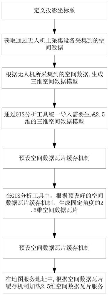
[0057] The present embodiment discloses a GIS-based 2.5-dimensional spatial data visualization method, which realizes visualization of 2.5-dimensional spatial data based on GIS tools, such as figure 1 As shown, the specific steps include:
[0058] S1. Data model construction and import, specifically including:
[0059] S101. Define a projected coordinate system:
[0060] According to the geographic location and map specifications that need to construct 2.5-dimensional spatial data, the projection is defined in advance, and the coordinate system of each spatial data is unified;
[0061] S102. Obtain the spatial data collected by the acquisition equipment on the drone, and determine the spatial data information that needs to be modeled; in this embodiment, the objects that need to be modeled in the space, such as buildings, etc., are collected by the acquisition equipment carried by the drone Its spatial data includes all information on the surface of the object, such as traje...
Embodiment 2
[0087] This embodiment discloses a GIS-based 2.5-dimensional spatial data visualization device, such as figure 2 shown in , including
[0088] The first module of spatial coordinate system is used to pre-define the projection and unify the coordinate systems of each spatial data according to the geographic location and map specifications that need to construct 2.5-dimensional spatial data.
[0089] The acquisition module is used to acquire the spatial data collected by the UAV. In this embodiment, objects that need to be modeled in space, such as buildings, etc., collect their spatial data through the acquisition equipment carried by the drone.
[0090] The data model generation module is used to generate a three-dimensional spatial data model according to the spatial data collected by the UAV, as well as the scale, precision and spatial data coordinate system.
[0091] The import module is used to uniformly import the 2.5-dimensional three-dimensional spatial data model th...
Embodiment 3
[0098] This embodiment discloses a storage medium, which stores a program. When the program is executed by a processor, the GIS-based 2.5-dimensional spatial data visualization method described in Embodiment 1 is implemented, as follows:
[0099] According to the geographic location and map specifications that need to construct 2.5-dimensional spatial data, the projection is defined in advance, and the coordinate system of each spatial data is unified;
[0100] Obtain spatial data collected by drones;
[0101] Generate a three-dimensional spatial data model based on the spatial data collected by the UAV, as well as the scale, accuracy and spatial data coordinate system;
[0102] A 2.5-dimensional 3D spatial data model needs to be generated for unified import through GIS analysis tools;
[0103] For the 3D spatial data model imported by GIS analysis tools, the preset spatial data tile caching mechanism;
[0104] In the GIS analysis tool, generate 2.5-dimensional spatial data ...
PUM
 Abstract
Description
Claims
Application Information
 - R&D
- Intellectual Property
- Life Sciences
- Materials
- Tech Scout
- Unparalleled Data Quality
- Higher Quality Content
- 60% Fewer Hallucinations
Browse by: Latest US Patents, China's latest patents, Technical Efficacy Thesaurus, Application Domain, Technology Topic, Popular Technical Reports.
© 2025 PatSnap. All rights reserved.Legal|Privacy policy|Modern Slavery Act Transparency Statement|Sitemap|About US| Contact US: help@patsnap.com


