Soil layer thickness measuring device for land surveying and mapping based on electronic information technology

A technology of electronic information and soil layer thickness, which is applied in the fields of on-site foundation soil survey, transportation and packaging, and infrastructure engineering, etc. problem, to achieve the effect of avoiding dumping, convenient measurement and strong adaptability

Inactive Publication Date: 2021-04-16
赵才
View PDF9 Cites 5 Cited by
  • Summary
  • Abstract
  • Description
  • Claims
  • Application Information

AI Technical Summary

Problems solved by technology

[0003] Operators often measure the thickness of the soil layer during land surveying and mapping. At present, it is impossible to measure the thickness of the soil layer remotely when measuring the thickness of the soil layer. Strong

Method used


Image

  • Soil layer thickness measuring device for land surveying and mapping based on electronic information technology
  • Soil layer thickness measuring device for land surveying and mapping based on electronic information technology
  • Soil layer thickness measuring device for land surveying and mapping based on electronic information technology

Examples


Embodiment Construction

[0022] The following will clearly and completely describe the technical solutions in the embodiments of the present invention with reference to the accompanying drawings in the embodiments of the present invention. Obviously, the described embodiments are only some, not all, embodiments of the present invention. Based on the embodiments of the present invention, all other embodiments obtained by persons of ordinary skill in the art without making creative efforts belong to the protection scope of the present invention.

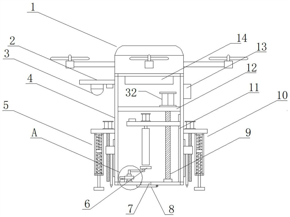
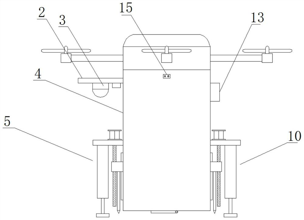
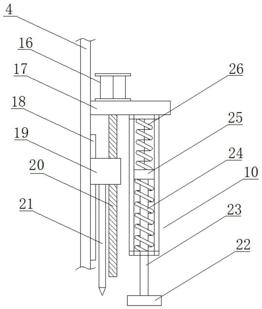
[0023] see Figure 1-5, in an embodiment of the present invention, a soil layer thickness measurement device for land surveying and mapping based on electronic information technology, including a drone main body 1, a mounting plate 2, a camera 3, a box body 4, a first buffer positioning device 5, and a landing plate 6 , hole 7, baffle plate 8, first lead screw 9, second buffer positioning device 10, first slide rail 11, first horizontal plate 12, controller 13...


PUM


Abstract

The invention discloses an electronic information technology-based soil layer thickness measuring device for land surveying and mapping, which comprises a box body, an unmanned aerial vehicle main body and a sampling cylinder, a third transverse plate is transversely arranged in the box body and located below the first transverse plate, and one side of the third transverse plate is slidably arranged on a first sliding rail. The first sliding rail is fixedly installed on one side of the inner wall of the box body, the first lead screw vertically penetrates through a third transverse plate, a threaded through hole used for being in threaded connection with the first lead screw is formed in the third transverse plate, and a third motor is fixedly installed at the top of the third transverse plate. The electric push rod drives the push rod to extend to drive the abutting plate to move upwards to abut against the sampling barrel, soil in the sampling barrel is prevented from falling off in the recycling process, the unmanned aerial vehicle body is further used for flying to recycle the box body, remote measurement of the soil layer thickness by operators is achieved, the operators do not need to arrive at the site personally, and time and labor are saved. The adaptability is high.

Description

technical field [0001] The invention relates to a measuring device, in particular to a soil layer thickness measuring device for land surveying and mapping based on electronic information technology. Background technique [0002] Land surveying and mapping refers to the use of computer technology, photoelectric technology, network communication technology, space science, and information science as the basis, with the global positioning system (GPS), remote sensing (RS), and geographic information system (GIS) For some feature points and boundaries, the graphics and location information reflecting the current situation of the ground are obtained by means of measurement, which are used for planning, design and administrative management of engineering construction. [0003] Operators often measure the thickness of the soil layer during land surveying and mapping. At present, it is impossible to measure the thickness of the soil layer remotely when measuring the thickness of the...

Claims


Application Information

Patent Timeline
Patent Type & Authority Applications(China)
IPC IPC(8): E02D1/04B64C39/02B64D47/08
Inventor 赵才王霞
Owner 赵才
Why Eureka
Try Eureka