Unmanned aerial vehicle assisted intelligent vehicle driving method and system based on indoor positioning

An indoor positioning and driving system technology, applied to radio wave measurement systems, positioning, motor vehicles, etc., can solve the problems of image positioning, sensing range and flexibility limitations, and lack of practicability, so as to improve positioning accuracy, The effect of improving reliability and stability

Inactive Publication Date: 2021-04-30
NANJING UNIV
View PDF7 Cites 6 Cited by
  • Summary
  • Abstract
  • Description
  • Claims
  • Application Information

AI Technical Summary

Problems solved by technology

[0003] However, traditional UAV-assisted smart car driving systems mostly rely on on-board sensors, which have great limitations in sensing range and flexibility
For example, patent 201810059695.9 proposes a collaborative navigation method for drones and smart cars based on image recognition. In this method, the real-time position of the car is known by default, and the positioning of the smart car is not considered, so it is not practical; in the journal paper of Ren Tao et al. In "Design of UAV and Smart Vehicle Collaborative Navigation System", it is considered that the UAV shoots the position of the target area through the camera. The limitation of this solution is that the UAV cannot locate the target through the image in the case of long-distance non-line-of-sight Area; patent 201910511710.3 proposes a system and method for autonomous collaborative transportation of UAVs and smart vehicles. The positioning considered in this method is through GPS positioning, which cannot be applied to scenarios without GPS signals
[0004] To sum up, the UAV-assisted smart car driving system in the prior art still needs to rely on sensors and GPS positioning, and it is impossible to realize UAV-assisted smart car driving in places where signal conditions are poor and GPS positioning cannot be used. the goal of

Method used


Image

  • Unmanned aerial vehicle assisted intelligent vehicle driving method and system based on indoor positioning
  • Unmanned aerial vehicle assisted intelligent vehicle driving method and system based on indoor positioning
  • Unmanned aerial vehicle assisted intelligent vehicle driving method and system based on indoor positioning

Examples


Embodiment 1

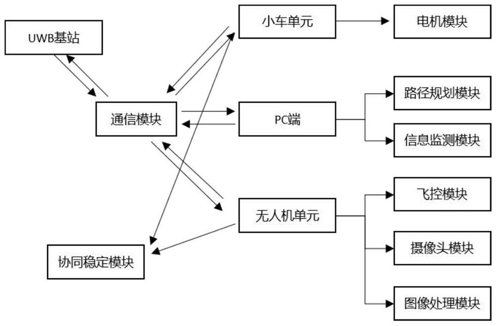
[0041] figure 1 The structural diagram of the UAV-assisted smart car driving system based on indoor positioning proposed in this embodiment includes a smart car unit, a UAV unit, a PC terminal, a UWB base station and a UWB positioning tag; wherein,

[0042] The smart car unit has electric drive and direction control functions, and is equipped with a signal receiving device, which completes the designated tracking route by receiving instructions from the PC terminal;

[0043] The UAV unit collects images of the surrounding environment of the smart car through the camera module on board, preprocesses the collected images and sends them to the PC. The man-machine unit adjusts the flight attitude according to the control commands issued by the PC;

[0044] The UWB positioning tag is set on the smart car unit and the UAV unit, and continuously sends UWB positioning pulses;

[0045] There are three UWB base stations, and the three UWB base stations respectively measure the UWB pos...

Embodiment 2

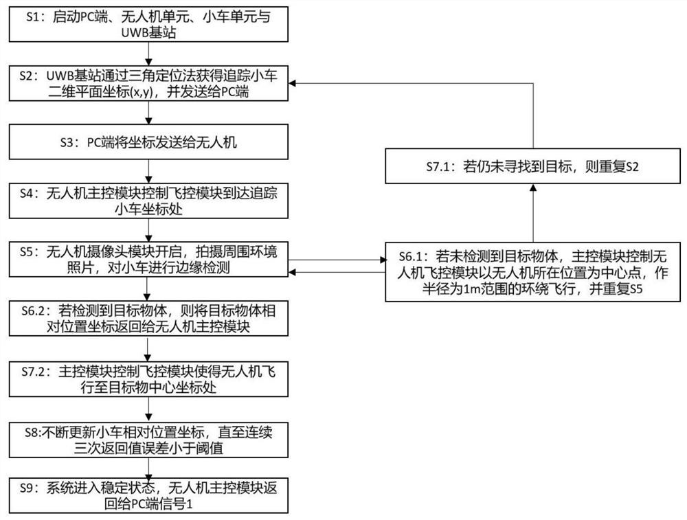
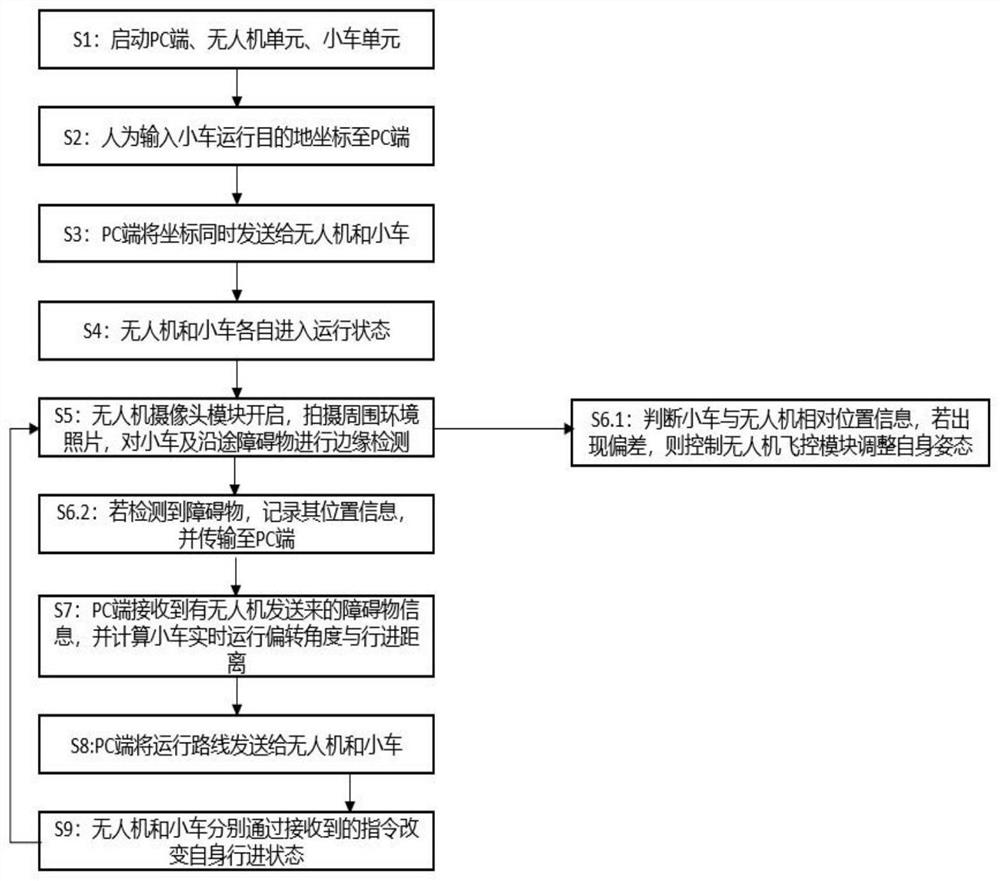
[0049] Based on the UAV-assisted smart car driving system based on indoor positioning proposed in Embodiment 1, this embodiment proposes a UAV-assisted smart car driving method based on indoor positioning. The method is generally divided into two processes. The first is The drone finds the smart car process, and the second is the drone-guided smart car obstacle avoidance process.

[0050] The process of drones looking for smart cars is as follows figure 2 shown, including the following steps:

[0051] (1) Construct a grid map of the site, and set artificial landmarks in the grid map;

[0052] (2) Set up the UWB base station in the field, and mark the coordinates of the UWB base station in the grid map;

[0053] (3) loading the grid map processed in step (2) to the PC;

[0054] (4) The PC terminal, UWB base station and UWB tags form a UWB positioning system, and the TOF algorithm is used to estimate the position of the UWB positioning tags, so as to realize the preliminary ...


PUM


Abstract

The invention discloses an unmanned aerial vehicle assisted intelligent vehicle driving system based on indoor positioning. The system comprises an intelligent vehicle unit, an unmanned aerial vehicle unit, a PC terminal, a UWB base station and a UWB positioning label. The intelligent vehicle unit has electric drive and direction control functions, is provided with a signal receiving device, and completes a specified tracking route by receiving an instruction sent by the PC terminal; the unmanned aerial vehicle unit carries out image acquisition on the surrounding environment of the intelligent vehicle through a carried camera module, acquired images are preprocessed and then sent to the PC terminal, and the acquired images all carry artificial marks preset in a site. Meanwhile, the unmanned aerial vehicle unit adjusts the flight attitude according to a control instruction issued by the PC terminal; the UWB positioning tags are arranged on the intelligent vehicle unit and the unmanned aerial vehicle unit and continuously send UWB positioning pulses; the UWB base stations respectively measure UWB positioning pulses and feed back measurement results to the PC terminal. According to the invention, the positioning precision is effectively improved, and a cooperative driving system without manual control between the unmanned aerial vehicle and the intelligent vehicle is realized.

Description

technical field [0001] The invention relates to the intersecting fields of UAV control technology, smart car control technology, and UWB positioning system, and in particular to a UAV-assisted smart car driving method and system based on indoor positioning. Background technique [0002] In the existing technology, in order to give full play to the respective functions of the UAV and the unmanned vehicle, and to better realize the autonomous driving ability of the unmanned vehicle in intelligent transportation, a scheme of cooperative driving of the unmanned aerial vehicle and the unmanned intelligent vehicle is proposed . [0003] However, traditional UAV-assisted smart car driving systems mostly rely on on-board sensors, which have great limitations in sensing range and flexibility. For example, patent 201810059695.9 proposes a collaborative navigation method for drones and smart cars based on image recognition. In this method, the real-time position of the car is known by...

Claims


Application Information

Patent Timeline
Patent Type & Authority Applications(China)
IPC IPC(8): G05D1/02G01C21/20G01S5/02
CPCG01C21/20G01S5/02G05D1/0221G05D1/0223G05D1/0253G05D1/0255G05D1/0276G05D1/0278G05D2201/0216
Inventor 傅爱勇李逸麒苏杭柏林王东鑫
Owner NANJING UNIV
Why Eureka
Try Eureka