Ground laser scanning three-dimensional point cloud data registration method

A terrestrial laser scanning and 3D point cloud technology, applied in cross-section drawing, image data processing, active optical measurement devices, etc., can solve problems such as difficult to obtain parameters, difficult to understand theory, complicated and difficult to understand, and achieve short registration time consumption , strong universality, and the effect of reducing the burden

Pending Publication Date: 2021-05-07
CHINA THREE GORGES UNIV
View PDF3 Cites 5 Cited by
  • Summary
  • Abstract
  • Description
  • Claims
  • Application Information

AI Technical Summary

Problems solved by technology

But traditional coordinate transformation models, such as the Bursa-Wolf model, the Molokinsky model, and the Paradigm model, are complex and difficult to understand based on small rotation angles, three rotation angle factors, and other translation factors. Model
These not only have problems that are difficult to understand in theory, but also have too many parameters, which makes it difficult to obtain the corresponding parameters in practical engineering applications.

Method used


Image

  • Ground laser scanning three-dimensional point cloud data registration method
  • Ground laser scanning three-dimensional point cloud data registration method
  • Ground laser scanning three-dimensional point cloud data registration method

Examples


Embodiment

[0085] Take the coordinate registration of the scanned point cloud of the excavation surface of a soil material field in a hydropower project in Southwest China as an example:

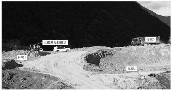
[0086] The stockyard is located about 36km upstream of the dam site, the distribution elevation of the stockyard is 2740-2865m, and the tug-of-war height at the front edge of the stockyard is about 85m. Cultivated land and residential buildings are distributed in the stockyard, which belongs to the submerged area of ​​the reservoir, with a total area of ​​about 19.5m2 2 . like Image 6 Shown is the topography of the excavation face. According to the above-mentioned point cloud registration steps, an embodiment of point cloud registration of a scan is described as follows.

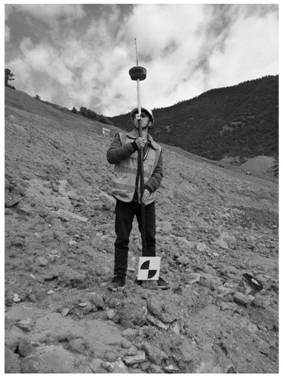
[0087] 1. Scanning and acquisition of point cloud, use a 3D laser scanner, the model is Leica ScanstationC10, to scan the point cloud and acquire the coordinates of the control points. like Figure 7 Shown is a point cloud imag...


PUM


Abstract

The invention discloses a ground laser scanning three-dimensional point cloud data registration method. The method comprises the following steps: establishing a point cloud registration model; and scanning original three-dimensional point cloud data under the relative coordinate system of the excavation surface of the earth material field, and calculating the theta around the Z axis between the relative coordinate system xoy of the registration model and the world coordinate system XOY, so that point cloud registration can be carried out. According to the point cloud data registration method, the registration efficiency is extremely high, a large amount of time can be saved in practical application, and time cost consumption can be reduced for engineering practical application.

Description

technical field [0001] The invention belongs to the technical field of calculating the excavation surface of a soil material field, and in particular relates to a ground laser scanning three-dimensional point cloud data registration method. Background technique [0002] With the rapid development of 3D laser scanning technology, the acquisition of massive point cloud data has become inevitable. The point cloud data scanned by the excavation surface of the soil material field usually requires multi-station and multi-angle scanning to obtain the complete point cloud data of the excavation surface, and the coordinate systems of the point cloud data of each station are independent of each other. It will cause great inconvenience. Therefore, in actual engineering applications, it is necessary to convert the coordinate point clouds scanned by different stations into the same coordinate system through the corresponding coordinate registration algorithm, and convert the relative co...

Claims


Application Information

Patent Timeline
Patent Type & Authority Applications(China)
IPC IPC(8): G06T7/35G01C7/00G01C15/00
CPCG06T7/35G01C7/00G01C15/002G06T2207/10028
Inventor 徐盛胡超陈廷才周宜红
Owner CHINA THREE GORGES UNIV
Why Eureka
Try Eureka