Remote sensing image space-time fusion method and system

A spatiotemporal fusion, remote sensing image technology, applied in image data processing, graphic image conversion, instruments, etc., can solve the problems of low accuracy and poor applicability of spatiotemporal fusion results

Active Publication Date: 2021-05-18
BEIJING NORMAL UNIVERSITY
View PDF8 Cites 4 Cited by
  • Summary
  • Abstract
  • Description
  • Claims
  • Application Information

AI Technical Summary

Problems solved by technology

[0003] The purpose of the present invention is to provide a remote sensing image spatio-temporal fusion method and system to s...

Method used


Image

  • Remote sensing image space-time fusion method and system
  • Remote sensing image space-time fusion method and system
  • Remote sensing image space-time fusion method and system

Examples


Embodiment Construction

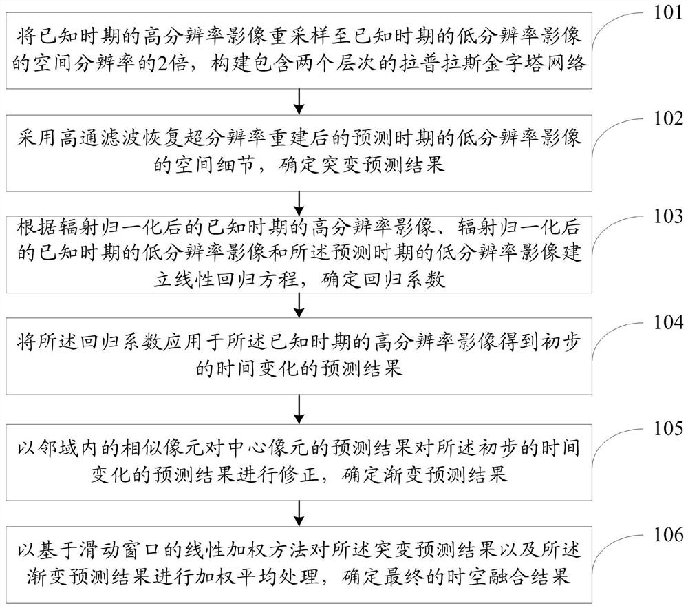
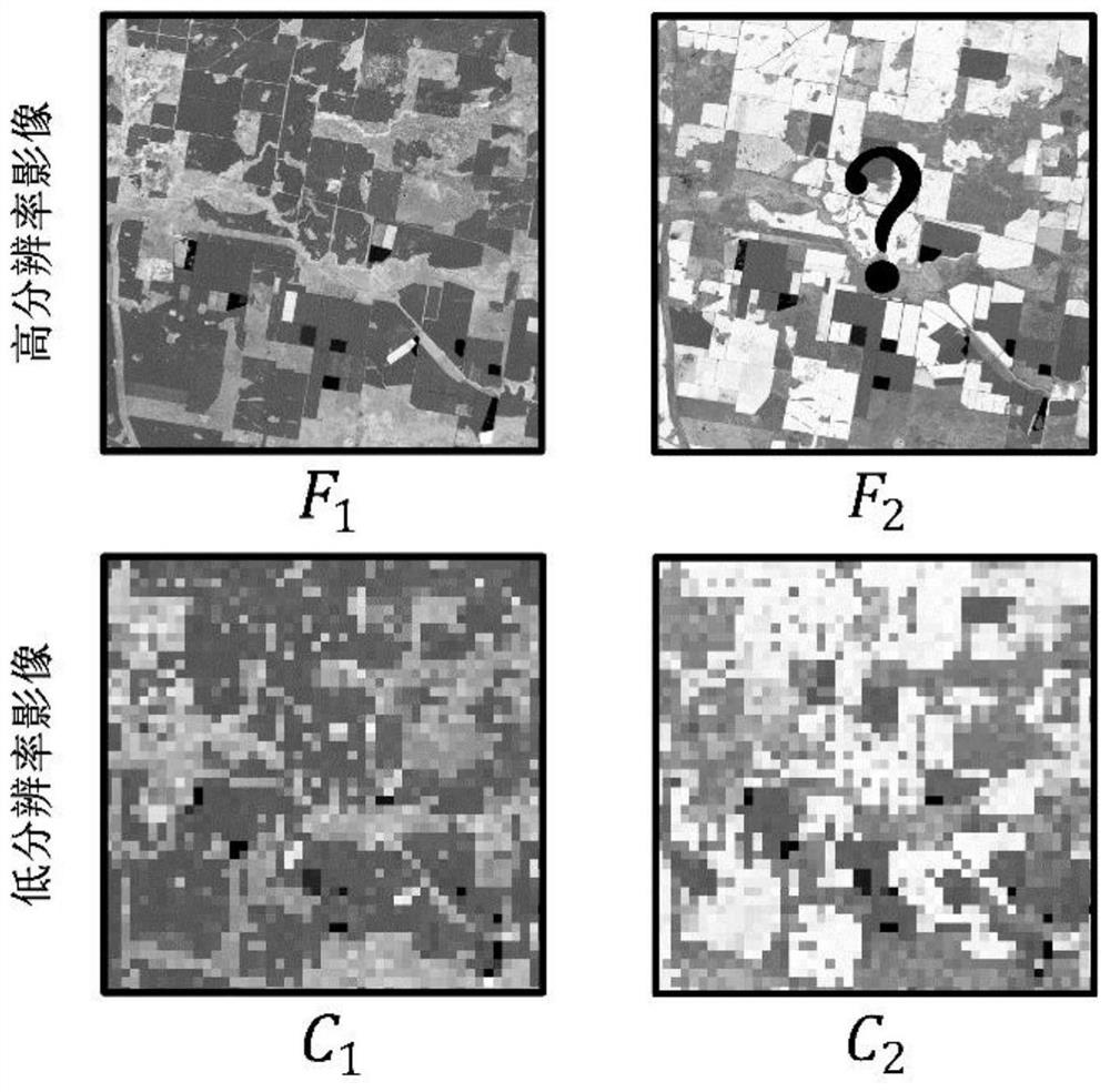
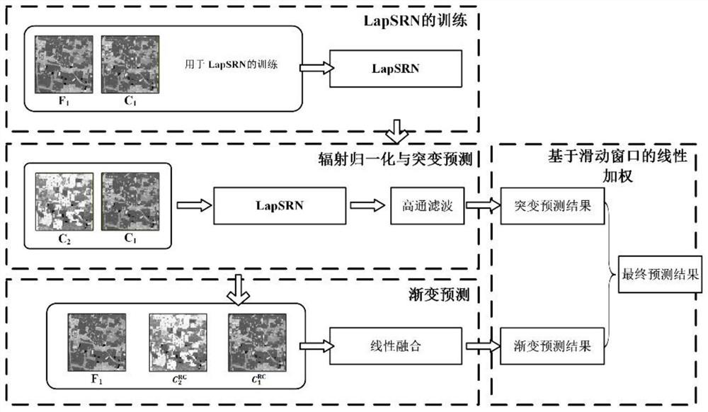
[0048] The following will clearly and completely describe the technical solutions in the embodiments of the present invention with reference to the accompanying drawings in the embodiments of the present invention. Obviously, the described embodiments are only some, not all, embodiments of the present invention. Based on the embodiments of the present invention, all other embodiments obtained by persons of ordinary skill in the art without making creative efforts belong to the protection scope of the present invention.

[0049] The purpose of the present invention is to provide a space-time fusion method and system for remote sensing images, which can improve the accuracy of space-time fusion results, and the applicability of the space-time fusion method and system in areas with severe cloud pollution.

[0050] In order to make the above objects, features and advantages of the present invention more comprehensible, the present invention will be further described in detail below...


PUM


Abstract

The invention relates to a remote sensing image space-time fusion method and system. The method comprises the following steps: resampling a high-resolution image in a known period to twice the spatial resolution of a low-resolution image in the known period, and constructing a Laplacian pyramid network comprising two layers; based on a Laplacian pyramid network, determining a sudden change prediction result and a regression coefficient; applying the regression coefficient to the high-resolution image in the known period to obtain a preliminary time change prediction result; correcting the preliminary time change prediction result by using similar pixels in a neighborhood, and determining a gradual change prediction result; performing weighted average processing on the sudden change prediction result and the gradual change prediction result by using a linear weighting method based on a sliding window, and determining a final time-space fusion result, wherein the final space-time fusion result is a high-resolution image in the prediction period.

Description

technical field [0001] The invention relates to the field of space-time fusion of remote sensing images, in particular to a method and system for space-time fusion of remote sensing images. Background technique [0002] Spatiotemporal fusion is a feasible and low-cost way to solve the constraint relationship between the spatial resolution and temporal resolution of a single satellite sensor to construct dense image time series. Such methods generate images with both high spatial resolution and high temporal resolution by fusing images with high spatial resolution and low temporal resolution (hereinafter referred to as high resolution images) and images with low spatial resolution and high temporal resolution (hereinafter referred to as low resolution images). dense image time series. The existing spatio-temporal fusion methods include the following problems: (1) It is difficult to simultaneously apply to the prediction of different types of surface time changes, including g...

Claims


Application Information

Patent Timeline
IPC IPC(8): G06T3/40
CPCG06T3/4053Y02A90/10
Inventor 贾铎程昌秀沈石宋长青
Owner BEIJING NORMAL UNIVERSITY
Why Eureka
Try Eureka