A device for gnss direct reflection signal carrier interferometry to measure lake water level

A technology of reflected signal and carrier interference, which is used in measurement devices, radio wave measurement systems, lubrication indicating devices, etc., can solve problems such as low time resolution, and achieve the effects of high measurement accuracy, low power consumption, and simple device structure.

Active Publication Date: 2022-04-15
BEIHANG UNIV
View PDF5 Cites 0 Cited by
  • Summary
  • Abstract
  • Description
  • Claims
  • Application Information

AI Technical Summary

Problems solved by technology

At present, the method of measuring the time delay of the reflected signal relative to the direct signal based on the carrier phase is the single-antenna interferometry, which uses the reflected signal to measure the height of the oscillation formed by the interference of the direct signal. The biggest disadvantage is that the time resolution is low, and only Applying low altitude satellite signals

Method used


Image

  • A device for gnss direct reflection signal carrier interferometry to measure lake water level
  • A device for gnss direct reflection signal carrier interferometry to measure lake water level
  • A device for gnss direct reflection signal carrier interferometry to measure lake water level

Examples


Embodiment Construction

[0041]The following will clearly and completely describe the technical solutions in the embodiments of the present invention with reference to the accompanying drawings in the embodiments of the present invention. Obviously, the described embodiments are only some, not all, embodiments of the present invention. Based on the embodiments of the present invention, all other embodiments obtained by persons of ordinary skill in the art without making creative efforts belong to the protection scope of the present invention.

[0042] In order to make the above objects, features and advantages of the present invention more comprehensible, the present invention will be further described in detail below in conjunction with the accompanying drawings and specific embodiments.

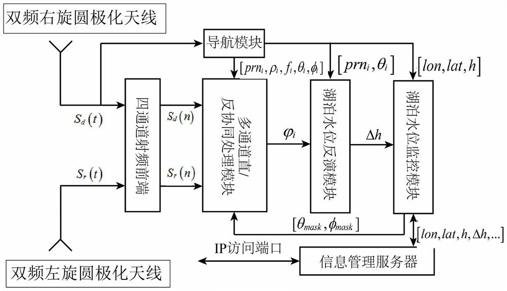
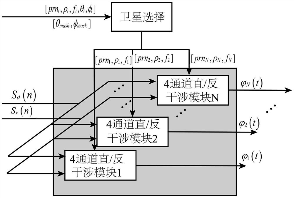
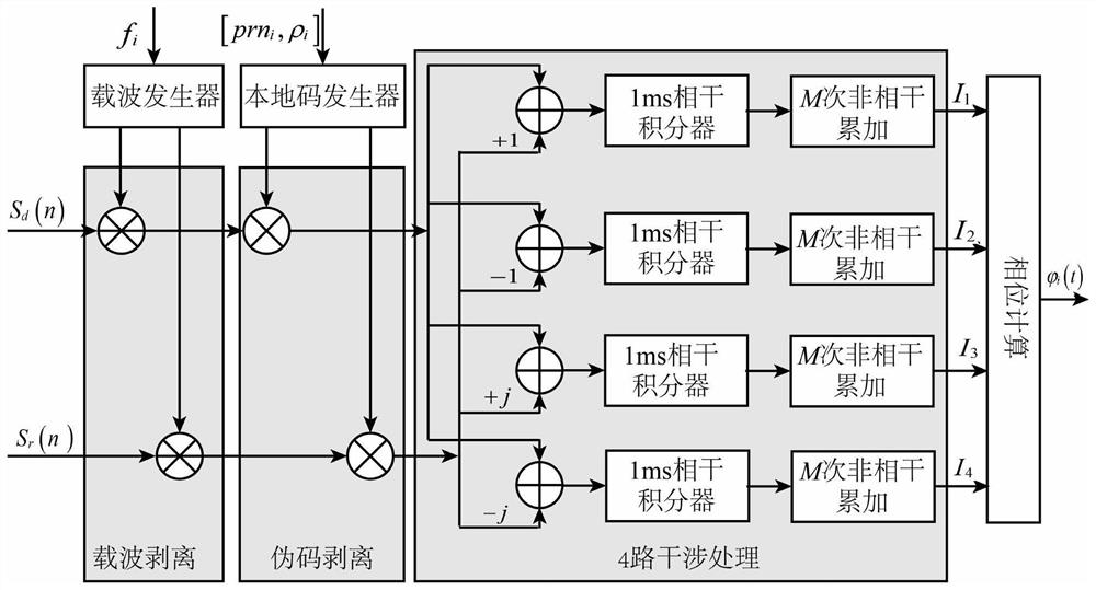
[0043] The present invention utilizes N (N=n+m; n is the number of GPS satellites visible to the reflection antenna, and m is the number of Beidou satellites visible to the reflection antenna) navigation satellite r...


PUM


Abstract

The invention discloses a device for measuring lake water level by GNSS direct reflection signal carrier interference. In this device, the dual-frequency right-handed circularly polarized antenna receives direct signals from N satellites in the navigation system; the navigation system includes the GPS satellite navigation system and the Beidou satellite navigation system; the dual-frequency left-handed circularly polarized antenna receives The reflection signal of the reflected navigation system; the dual-mode navigation module generates positioning information; the four-channel RF front-end converts the direct signal and the reflected signal to obtain four digital intermediate frequency signals; The intermediate frequency signal is subjected to interference processing to obtain the carrier phase delay of the reflected signal relative to the direct signal; the lake water level inversion module is used to perform inversion according to the carrier phase delay and positioning information to obtain the water level of the lake to be measured. The invention is applied to a plurality of satellite signals with different elevation angles to obtain the lake water level, has high measurement accuracy and wide application range.

Description

technical field [0001] The invention relates to the field of lake water level measurement, in particular to a device for measuring lake water level by GNSS direct reflection signal carrier interferometry. Background technique [0002] The inversion of the physical parameters of the earth's surface using the reflected signals of the Global Navigation Satellite System (GNSS) is one of the new technologies in the field of remote sensing, which has the advantages of wide signal sources, low cost, and light detection equipment. This technology can detect surface physical parameters by receiving and processing GNSS reflection signals through spaceborne, airborne or shore-based special devices. [0003] As an important hydrological parameter, lake water level has been one of the long-term concerns in the field of inland remote sensing. The GNSS reflected signal altimeter was originally proposed as an alternative technology to the traditional altimeter. The path delay of the reflec...

Claims


Application Information

Patent Timeline
Patent Type & Authority Patents(China)
IPC IPC(8): G01F23/284G01S19/33G01S19/43
CPCG01F23/284G01S19/33G01S19/43
Inventor 王峰杨东凯张波张国栋
Owner BEIHANG UNIV
Why Eureka
Try Eureka