Pollution condition monitoring method based on satellite remote sensing technology
A satellite remote sensing and pollution technology, applied in the field of atmospheric remote sensing, can solve the problems of low accuracy, difficulty in manual measurement, and low efficiency.
- Summary
- Abstract
- Description
- Claims
- Application Information
AI Technical Summary
Problems solved by technology
Method used
Image
Examples
Embodiment Construction
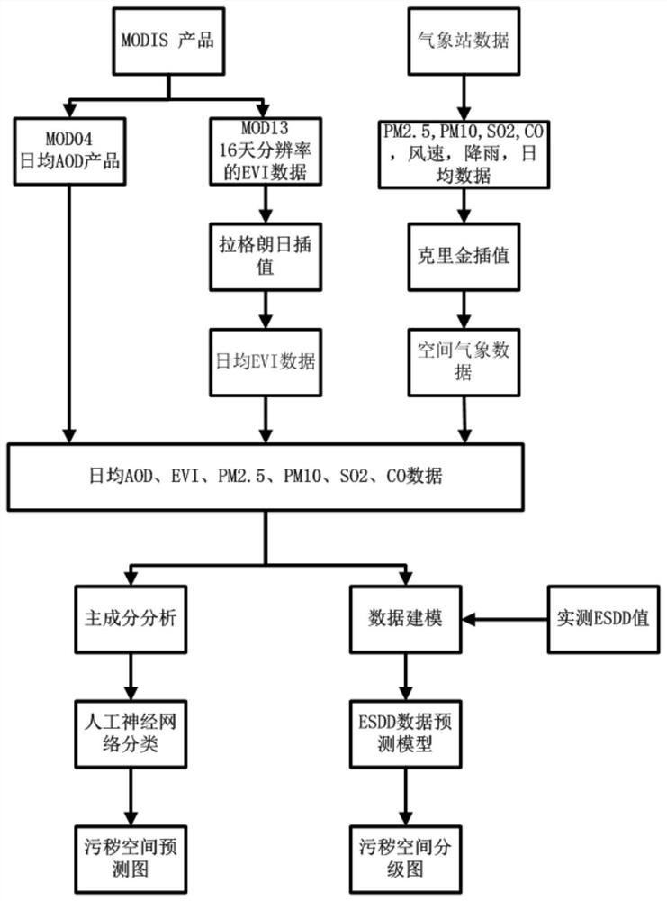
[0042] see figure 1 , is a schematic flow chart of a pollution monitoring method based on satellite remote sensing technology for this application, see figure 1 , the present application provides a pollution monitoring method based on satellite remote sensing technology based on steps such as the processing of satellite remote sensing images, the combination of satellite data and ground data, and the generation of pollution maps. The method includes:
[0043] Obtain aerosol optical depth (AOD) and enhanced vegetation index (EVI) through MODIS satellite;
[0044] Stitching, cropping and defining a geographic coordinate system to the aerosol optical depth AOD and the enhanced vegetation index EVI;
[0045] Obtain MODIS High Temporal Resolution and High Spatial Resolution (https: / / ladsweb.modaps.eosdis.nasa.gov / ) mean daily aerosol optical depth AOD data (MOD04). When the research area is in different areas, MRT tools need to be used for splicing. The downloaded aerosol optica...
PUM
 Abstract
Description
Claims
Application Information
 - R&D
- Intellectual Property
- Life Sciences
- Materials
- Tech Scout
- Unparalleled Data Quality
- Higher Quality Content
- 60% Fewer Hallucinations
Browse by: Latest US Patents, China's latest patents, Technical Efficacy Thesaurus, Application Domain, Technology Topic, Popular Technical Reports.
© 2025 PatSnap. All rights reserved.Legal|Privacy policy|Modern Slavery Act Transparency Statement|Sitemap|About US| Contact US: help@patsnap.com


