Real-time track obstacle detection method based on three-dimensional point cloud

A technology of obstacle detection and 3D point cloud, applied in radio wave measurement system, image data processing, instrument, etc., can solve problems such as lack of spatial information, camera is easily affected by environmental factors, etc.

Pending Publication Date: 2021-09-10
ZHEJIANG UNIV OF TECH
View PDF0 Cites 2 Cited by
  • Summary
  • Abstract
  • Description
  • Claims
  • Application Information

AI Technical Summary

Problems solved by technology

[0005] The invention aims to overcome the shortcomings of the existing technology that the camera is easily affected by enviro

Method used


Image

  • Real-time track obstacle detection method based on three-dimensional point cloud
  • Real-time track obstacle detection method based on three-dimensional point cloud
  • Real-time track obstacle detection method based on three-dimensional point cloud

Examples


Embodiment Construction

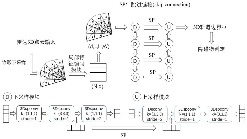
[0036] Further illustrate technical scheme of the present invention below in conjunction with accompanying drawing, flow chart of the present invention is as follows image 3 shown.

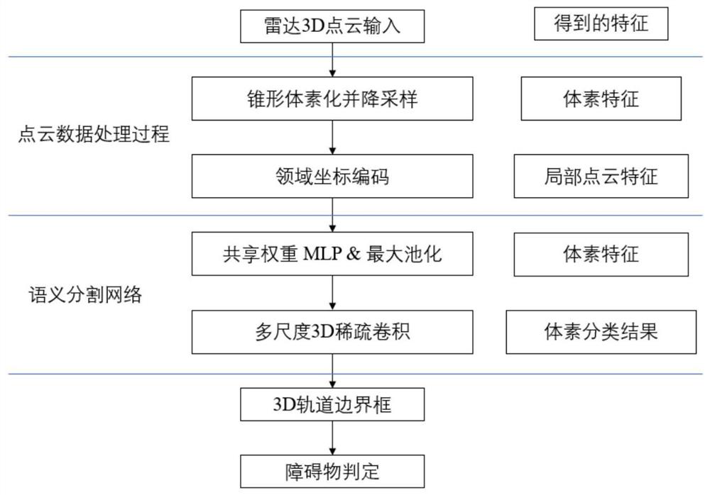
[0037] The present invention is a real-time track obstacle detection method based on a three-dimensional point cloud, and the specific steps are as follows:

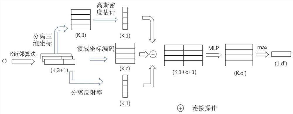
[0038]Step 1: Carry out coordinate transformation on the real-time 3D lidar point cloud data, convert the point cloud coordinates in the European coordinate system to the coordinates in the spherical coordinate system, the coordinate representation is shown in Figure 4, and use the cone division method for the point cloud sampling. The coordinate relationship before and after transformation is shown in formula (1), where α represents the elevation angle on the XOY plane with respect to the Z axis from the left view, β represents the horizontal direction angle of the XOY plane from the top view, and γ represents the distance between the ori...


PUM


Abstract

The invention discloses a real-time track obstacle detection method based on a three-dimensional point cloud, and the method comprises the steps: carrying out the processing of three-dimensional point cloud sequence data collected by a laser radar, firstly carrying out the coordinate transformation of the point cloud, converting the coordinates in a European coordinate system into the coordinates in a spherical coordinate system, putting each point in the point cloud into a certain voxel of a cone by using a cone voxelization down-sampling method so as to reduce the calculation amount of subsequent steps; inputting the downsampled points into a local feature coding module, searching local point clouds by using K-nearest neighbor (KNN), aggregating geometric features of the local point clouds, and connecting the centroid, neighbor point coordinates, relative coordinates and Gaussian density features of the local point clouds into a vector; connecting all local point cloud information into a matrix through traversal, and obtaining high-dimensional local feature information of each local point cloud through MLP and maximum pooling; and finally, utilizing multi-scale three-dimensional sparse convolution to realize track real-time identification of a single-frame image through a plurality of down-sampling and up-sampling modules.

Description

technical field [0001] The invention relates to a semantic segmentation technology based on three-dimensional point cloud vision, in particular to a method for judging whether an obstacle exists on a rail transit. Background technique [0002] Railway transportation is an important carrier of personnel flow, and is recognized as a comfortable, fast and safe transportation method. Safety monitoring has always been an important part of railway transportation automation. However, the complex environment of the railway laying area has brought great challenges to train safety. However, at present, most routes still rely on the driver's judgment to ensure driving safety, such as judging whether the front is safe by identifying signal lights. With the application of smart technology, vehicle assistance systems based on on-board sensors have been developed for many years. In this case, it is an effective way to develop a train assisted driving system based on on-board sensors. O...

Claims


Application Information

Patent Timeline
IPC IPC(8): G06K9/00G06T7/73G06T7/66G01S7/48
CPCG06T7/73G06T7/66G01S7/4802G06T2207/10028G06T2207/10044G06T2207/30252
Inventor 杨阳何伟琪禹鑫燚欧林林
Owner ZHEJIANG UNIV OF TECH
Why Eureka
Try Eureka