High-standard farmland acceptance method based on multi-rotor unmanned aerial vehicle

A multi-rotor unmanned aerial vehicle and unmanned aerial vehicle technology, applied in the field of unmanned aerial vehicle survey, can solve the problems of lack of effective monitoring means in the acceptance process, heavy workload in the field, and disputes in spot checks, etc., so as to facilitate the monitoring of construction progress and acceptance results, strong mobility, and low cost of image acquisition

Pending Publication Date: 2021-09-21
湖北智凌数码科技有限公司
View PDF3 Cites 1 Cited by
  • Summary
  • Abstract
  • Description
  • Claims
  • Application Information

AI Technical Summary

Problems solved by technology

[0002] In the existing high-standard basic farmland construction project work, both the planning and design before the project construction and the completion acceptance after the completion of the project must carry out field surveys and completion surveying and mapping, and those in the process of project implementation can only go to the project area for spot checks Reconnaissance, not only the workload in the field is heavy, but also there are often disputes due to spot checks, and the entire acceptance process lacks effective monitoring means

Method used


Image

  • High-standard farmland acceptance method based on multi-rotor unmanned aerial vehicle
  • High-standard farmland acceptance method based on multi-rotor unmanned aerial vehicle
  • High-standard farmland acceptance method based on multi-rotor unmanned aerial vehicle

Examples


Embodiment Construction

[0055] The present invention will be further described in detail below in conjunction with the accompanying drawings and specific embodiments.

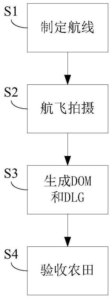
[0056] see figure 1 , an embodiment of the present invention includes the following steps:

[0057]Before the flight, collect the planning and design data of the project, the change approval in the project implementation, and the one-way project acceptance, etc., and generate the DXF format through the CAD software for the project scope line and the new one-way project, and generate the KML format through the software, and then The KML file is imported into the Tiantu map platform, the route of the flight area is predicted and designed indoors, and the technical design document of the project is prepared. According to the production requirements of the project, the location of control points is designed in accordance with the specifications, the terrain of the detection area is surveyed in advance, and the good weather is predicted. ...


PUM


Abstract

According to a high-standard farmland acceptance method based on a multi-rotor unmanned aerial vehicle provided by the invention, a measurement mode of improving a land reclamation project through unmanned aerial vehicle measurement is achieved, the function of visually and efficiently measuring the high-standard basic farmland construction progress is achieved, and monitoring of the construction progress and acceptance results is facilitated. According to the invention, the low-altitude unmanned aerial vehicle photogrammetry technology is adopted to carry out low-altitude aerial photography on main engineering facilities such as canals and production roads in a high-standard project area, and then data processing is carried out to generate orthoimages and line maps, so that information such as spatial positions, spatial distribution, lengths and the like of the canals, the roads and the facilities is accurately reflected; whether the channels, the roads and the facilities are changed or not can be quickly checked by nesting the images and the planning data, the defects of traditional manual measurement are effectively overcome, interference of human factors is reduced, the working intensity of field operation workers is reduced, and the high-standard project rechecking efficiency is improved. And the management level of a high-standard supervision department is improved.

Description

technical field [0001] The invention belongs to the field of unmanned aerial vehicle survey technology, and in particular relates to a high-standard farmland acceptance method based on a multi-rotor unmanned aerial vehicle. Background technique [0002] In the existing high-standard basic farmland construction project work, both the planning and design before the project construction and the completion acceptance after the completion of the project must carry out field survey and completion surveying and mapping, and the project implementation can only go to the project area for spot checks Reconnaissance, not only the workload in the field is heavy, but also there are often disputes due to spot checks, and the entire acceptance process lacks effective monitoring methods. Contents of the invention [0003] The technical problem to be solved by the present invention is to provide a high-standard farmland acceptance method based on a multi-rotor UAV, which is used to intuiti...

Claims


Application Information

Patent Timeline
Patent Type & Authority Applications(China)
IPC IPC(8): G01C11/04
CPCG01C11/04
Inventor 何明
Owner 湖北智凌数码科技有限公司
Why Eureka
Try Eureka