Rock-soil mass parameter two-dimensional space variability characterization method based on multi-surface wave exploration

A two-dimensional space, rock and soil technology, applied in the direction based on specific mathematical models, special data processing applications, instruments, etc., can solve the problems of rock and soil disturbance, untestable, difficult to predict unknown soil layers, etc., to overcome limitations. , the effect of improving the accuracy

Active Publication Date: 2021-09-24
POWERCHINA HUADONG ENG COPORATION LTD
View PDF7 Cites 3 Cited by
  • Summary
  • Abstract
  • Description
  • Claims
  • Application Information

AI Technical Summary

Problems solved by technology

[0003] At present, the widely used characterization model for the spatial variability of rock and soil parameters is the random field model. Directly identify the two-dimensional stationary random field model to characterize the spatial variability of rock and soil parameters based on the surveyed two-dimensional profile data
In addition, the in-situ test methods mentioned above are all intrusive tests, which will cause disturbance to the rock and soil mass of the site
Engineers cannot test every position of the site, and for the spatial positions without any survey information in the geotechnical engineering site, they can only infer and predict based on limited survey information
Although there are many interpolation methods and fitting methods, it is still difficult to predict possible unknown soil layers, such as the presence of different rock and soil types between two adjacent boreholes or survey points or local weak interlayer lenses Wait
Therefore, it is impossible to obtain a comprehensive spatial variability of the rock and soil mass on the site based only on the in-situ test and survey information.
The non-intrusive multi-channel surface wave exploration method can provide two-dimensional spatial data, but the traditional steady-state random field model is difficult to capture the two-dimensional spatial variation trend of rock and soil parameters

Method used


Image

  • Rock-soil mass parameter two-dimensional space variability characterization method based on multi-surface wave exploration
  • Rock-soil mass parameter two-dimensional space variability characterization method based on multi-surface wave exploration
  • Rock-soil mass parameter two-dimensional space variability characterization method based on multi-surface wave exploration

Examples


Embodiment Construction

[0129] The present invention will be described in detail below in conjunction with the accompanying drawings and specific examples.

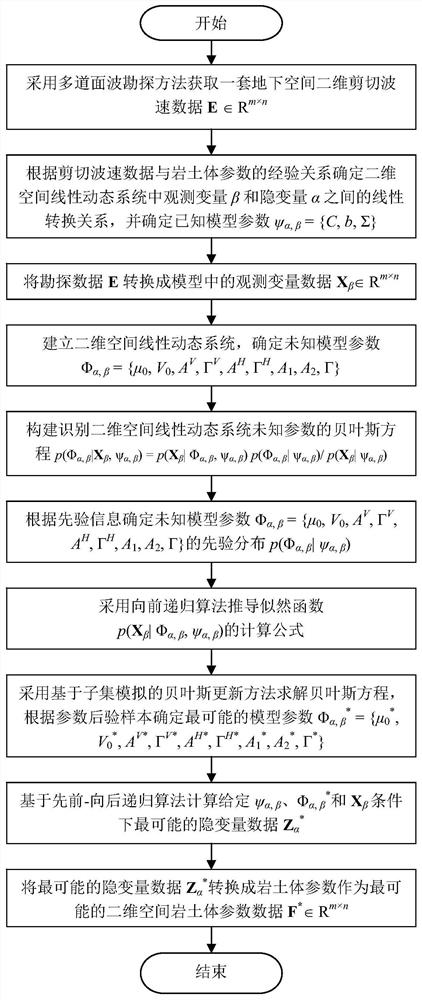
[0130] like figure 1 As shown, the method for characterizing the two-dimensional spatial variability of rock and soil parameters based on multi-channel surface wave exploration in the present invention, the specific implementation process is as follows:

[0131] (1), using the multi-channel surface wave exploration method to collect the spatial two-dimensional shear wave velocity data of rock and soil mass, use the matrix E=(e i,j )∈R m×n express.

[0132] (2) According to the empirical relationship formula between the shear wave velocity e and the rock and soil mass parameter f in the historical literature, the linear conversion relationship between the observed variable β and the hidden variable α in the two-dimensional space linear dynamic system is derived:

[0133] β=Cα+b+ν (1)

[0134] In the formula: the observed variable β is a funct...


PUM


Abstract

The invention relates to a rock-soil mass parameter two-dimensional space variability characterization method based on multi-surface wave exploration, and belongs to the field of geotechnical engineering investigation. The method includes establishing a two-dimensional space linear dynamic system for representing the spatial variability of the rock and earth mass parameters; constructing a Bayesian equation for identifying parameters of a two-dimensional space linear dynamic system according to a Bayesian theory under the condition that two-dimensional shear wave velocity data of multi-surface wave exploration and an empirical relationship between exploration data in literatures and rock-soil body parameters are given; solving optimal model parameters by adopting a Bayesian updating method based on subset simulation; and obtaining the most possible two-dimensional spatial distribution of the rock-soil body parameters by adopting a forward recursive algorithm and a backward recursive algorithm. According to the invention, the influence of the two-dimensional spatial correlation of the shear wave velocity data on the spatial variability characterization recognition of the rock-soil body parameters is reasonably considered, the two-dimensional spatial exploration data are fully utilized to characterize the unstable spatial variability of the rock-soil body parameters, the limitation of a traditional steady-state random field model is overcome, and an effective way is provided for improving the exploration accuracy of a geotechnical engineering site.

Description

technical field [0001] The invention relates to the field of geotechnical engineering investigation, in particular to a method for characterizing the two-dimensional spatial variability of rock and soil parameters based on multi-channel surface wave exploration. Background technique [0002] During its formation, the rock and soil body has experienced various complex geological actions, so it has a complex structure. Therefore, in the design of geotechnical engineering, engineers not only have to face complex stratum structures, but also take into account the spatial variability of geotechnical types and physical and mechanical properties. The accuracy and reliability of geotechnical parameters (such as soil bulk density and effective friction angle) will directly affect the results of geotechnical engineering design. However, there are uncertainties in the geotechnical parameters and stratigraphic profiles described by engineers based on limited survey data. In order to r...

Claims


Application Information

Patent Timeline
Patent Type & Authority Applications(China)
IPC IPC(8): G06F30/20G06K9/62G06N7/00G06F111/08
CPCG06F30/20G06F2111/08G06N7/01G06F18/2321Y02A90/30
Inventor 郑硕吴关叶郑惠峰刘宁
Owner POWERCHINA HUADONG ENG COPORATION LTD
Why Eureka
Try Eureka