
A landslide underwater network-type three-dimensional deformation monitoring system and monitoring method

A technology of three-dimensional deformation and monitoring system, applied in the direction of radio wave measurement system, satellite radio beacon positioning system, measurement device, etc., can solve the problems that traditional monitoring technology cannot be applied, and achieve the effect of simple structure and reasonable design

Active Publication Date: 2022-03-15
CHINA UNIV OF GEOSCIENCES (WUHAN)
View PDF0 Cites 0 Cited by
  • Summary
  • Abstract
  • Description
  • Claims
  • Application Information

AI Technical Summary

Problems solved by technology

However, due to the challenges of underwater deformation monitoring of landslides such as waterproofing and underwater deformation feature acquisition, traditional monitoring techniques cannot be effectively applied in underwater environments

Method used


Image

  • A landslide underwater network-type three-dimensional deformation monitoring system and monitoring method
  • A landslide underwater network-type three-dimensional deformation monitoring system and monitoring method
  • A landslide underwater network-type three-dimensional deformation monitoring system and monitoring method

Examples


Embodiment Construction

[0033] In order to make the purpose, technical solution and advantages of the present invention clearer, the embodiments of the present invention will be further described below in conjunction with the accompanying drawings.

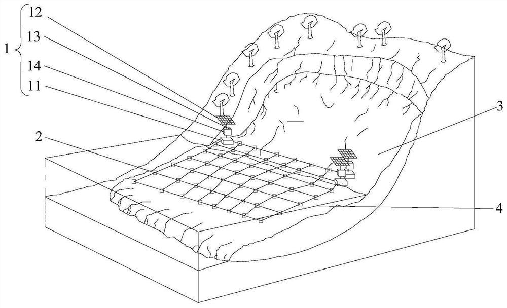
[0034] See Figure 1 to Figure 4 , the embodiment of the present invention provides an underwater landslide network-type three-dimensional deformation monitoring system, including a plurality of monitoring stations 1 and a plurality of underwater multifunctional 3D displacement meters 2 .

[0035] The multiple underwater multifunctional 3D displacement gauges 2 are arranged in a grid pattern and connected in sequence, and are fixed on the surface of the water slide body 3 and the surface of the underwater slide body 3 for monitoring the underwater deformation evolution process of the landslide. Each of the above-water monitoring stations 1 is fixedly connected to one of the underwater multifunctional 3D displacement gauges 2 on the surface of the water s...


PUM


Abstract

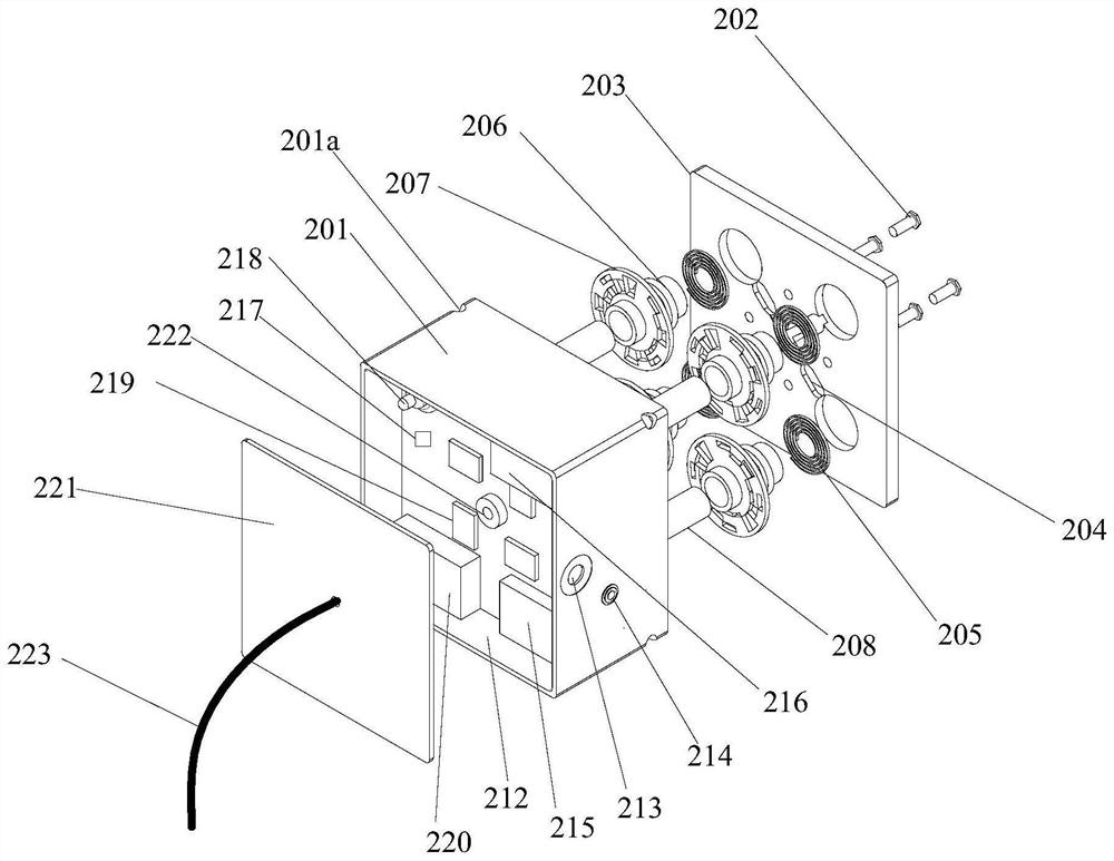
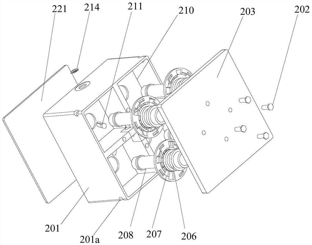
The invention provides a landslide underwater net-type three-dimensional deformation monitoring system and monitoring method. A plurality of underwater multifunctional 3D displacement gauges are arranged in a lattice structure and connected in sequence. Four rotating shafts are rotatably installed in the housing, and the rotating shafts are arranged along the Extending up and down, one end of the rotating shaft is connected to the casing with a shrinking mainspring, and four perforations are set through the casing at intervals in the circumferential direction. The pull wires correspond to the perforations one by one. The stay wire connection of the adjacent underwater multifunctional 3D displacement gauge; the displacement gauge corresponds to the stay wire, and measures the retractable length of the stay wire. The three-axis acceleration sensor and the fluxgate monitor the inclination angle and azimuth change of the underwater multifunction 3D displacement gauge. The beneficial effect of the technical solution proposed by the present invention is: based on the networked monitoring method, the spatial state changes of a large number of points on the landslide surface can be sensed, and the inversion integral calculation can be used to indirectly obtain the underwater deformation evolution characteristics of the landslide, which is the largest displacement of the existing landslide. A useful supplement to monitoring tools.

Description

technical field [0001] The invention relates to the technical field of landslide disaster monitoring, in particular to a landslide underwater net-type three-dimensional deformation monitoring system and a monitoring method. Background technique [0002] The mountains in the central and western regions of my country are widely distributed, with sufficient rainwater conditions and frequent geological disasters. Every year, the human and financial losses caused by geological disasters are huge, of which landslide disasters account for about 2 / 3 of the total. Water is an important inducing factor of landslide geological disaster, so it is also an important content of landslide geological disaster monitoring. In recent years, the periodic fluctuation of the water level of the Three Gorges Reservoir has caused a large number of ancient landslides to re-slide. Taking corresponding monitoring methods and continuously monitoring the deformation characteristics of reservoir landslides...

Claims


Application Information

Patent Timeline
Patent Type & Authority Patents(China)
IPC IPC(8): G01B11/16G01S19/14G01D21/02H02J7/35
CPCG01B11/16G01S19/14G01D21/02H02J7/35
Inventor 张俊荣唐辉明张永权李长冬张青马俊伟夏丁林成远鲁莎
Owner CHINA UNIV OF GEOSCIENCES (WUHAN)
Learn More