An Image Block Adjustment Method Constrained by Global Digital Elevation Model

A technology of digital elevation model and block network adjustment, which is applied to the interpretation of photos, etc., to achieve the effect of simple operation steps, improved operation efficiency, and high operation efficiency

Active Publication Date: 2022-03-01
自然资源部国土卫星遥感应用中心
View PDF4 Cites 0 Cited by
  • Summary
  • Abstract
  • Description
  • Claims
  • Application Information

AI Technical Summary

Problems solved by technology

[0006] The object of the present invention is to provide a kind of image block adjustment method constrained by the global digital elevation model, thereby solving the aforementioned problems existing in the prior art

Method used


Image

  • An Image Block Adjustment Method Constrained by Global Digital Elevation Model
  • An Image Block Adjustment Method Constrained by Global Digital Elevation Model
  • An Image Block Adjustment Method Constrained by Global Digital Elevation Model

Examples


Embodiment Construction

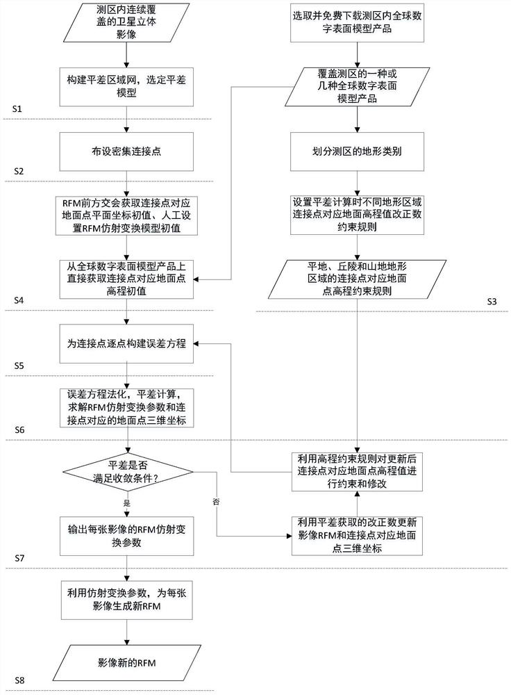
[0068] In order to make the object, technical solution and advantages of the present invention clearer, the present invention will be further described in detail below in conjunction with the accompanying drawings. It should be understood that the specific embodiments described here are only used to explain the present invention, and are not intended to limit the present invention.

[0069] Such as figure 1 As shown, in this embodiment, an image block adjustment method constrained by a global digital elevation model is provided, including the following steps,

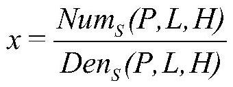
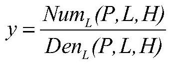
[0070] S1. Construct an adjustment block network from the remote sensing satellite stereo images continuously covered in the survey area, and use the block adjustment model based on the rational function model (RFM) for image square affine transformation compensation;

[0071] S2. Arrange dense connection points on the three-dimensional image in the adjustment block network;

[0072] S3. Select and download one or mor...


PUM


Abstract

The invention discloses an image area network adjustment method constrained by a global digital elevation model. Firstly, a three-dimensional image adjustment area network is constructed and dense connection points are arranged. Then obtain the global digital elevation model data in the survey area, divide the survey area into three types of terrain areas: flat land, hills and mountains, and set the elevation values ​​corresponding to ground points in different terrain areas obtained by using the global digital elevation model data for adjustment calculations Constraint rules for the correction number; finally carry out block network adjustment calculation, use this constraint rule to constrain the elevation value correction number of the connection point corresponding to the ground point in each iterative calculation, until the end of the adjustment, and according to the adjustment result as A new imaging geometry model parameter file is generated for each image. The invention implements elevation constraints on regional network adjustments by adopting different rules in different terrain areas and using global digital elevation models, so as to realize a substantial improvement in the elevation accuracy of satellite remote sensing images under the condition of no ground control.

Description

technical field [0001] The invention relates to the technical field of photogrammetry, in particular to an image block adjustment method constrained by a global digital elevation model. Background technique [0002] The digital elevation model is a solid ground model that expresses the ground elevation in the form of a set of ordered numerical arrays. At present, the global digital elevation model products that can be obtained free of charge through the Internet mainly include: ① SRTM-DEM (full name Space Shuttle Radar Topography Mission): produced by NASA and others and provided free of charge, its data coverage ranges from 60° north latitude to All land areas between 56° south latitude account for 80% of the earth's land surface. The world's highest resolution is 30 meters, and the official nominal elevation has an error of 10 meters. ②ASTER GDEM (full name Advanced Spaceborne Thermal Emission and Reflection Radiometer Global Digital Elevation Model): It is jointly produc...

Claims


Application Information

Patent Timeline
Patent Type & Authority Patents(China)
IPC IPC(8): G01C11/04
CPCG01C11/04
Inventor 周平唐新明王懿哲王霞刘昌儒王艺颖岳明宇郭莉李丹丹
Owner 自然资源部国土卫星遥感应用中心
Why Eureka
Try Eureka