
Water and soil loss quantitative monitoring method based on multi-source data and multi-temporal data

A multi-source data and multi-temporal technology, applied in data processing applications, resources, character and pattern recognition, etc., can solve problems such as the inability to obtain large-scale soil erosion information, the difficulty of obtaining data, and the unobjective amount of soil erosion

Pending Publication Date: 2021-11-02
FUJIAN NORMAL UNIV
View PDF0 Cites 1 Cited by
  • Summary
  • Abstract
  • Description
  • Claims
  • Application Information

AI Technical Summary

Problems solved by technology

[0011] Due to the difficulty of obtaining data, the existing methods can only obtain the amount of soil erosion through field measurement in a small area. If it is in a large area, the amount of soil erosion obtained is not objective and is quite different from the actual situation. At present, people cannot obtain large-scale Soil and water loss information with clear scientific basis, let alone long-term dynamic monitoring of regional water and soil loss

Method used


Image

  • Water and soil loss quantitative monitoring method based on multi-source data and multi-temporal data
  • Water and soil loss quantitative monitoring method based on multi-source data and multi-temporal data
  • Water and soil loss quantitative monitoring method based on multi-source data and multi-temporal data

Examples


Embodiment Construction

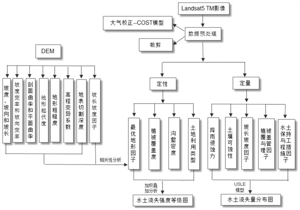
[0064] As shown in the accompanying drawings, the implementation steps of the soil erosion quantitative monitoring method based on multi-source data and multi-temporal data in this embodiment are as follows:

[0065] 1) Obtain the original remote sensing image of the area to be monitored, and perform atmospheric correction on the original remote sensing image. According to the theory and method of the COST model, obtain the parameter values ​​required in the COST model from different ways, and perform band calculation on the original image according to the calculation process of the COST model. Calculate the surface reflectance value of the image;

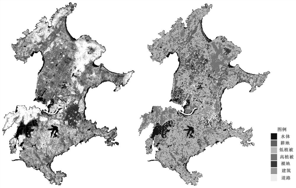
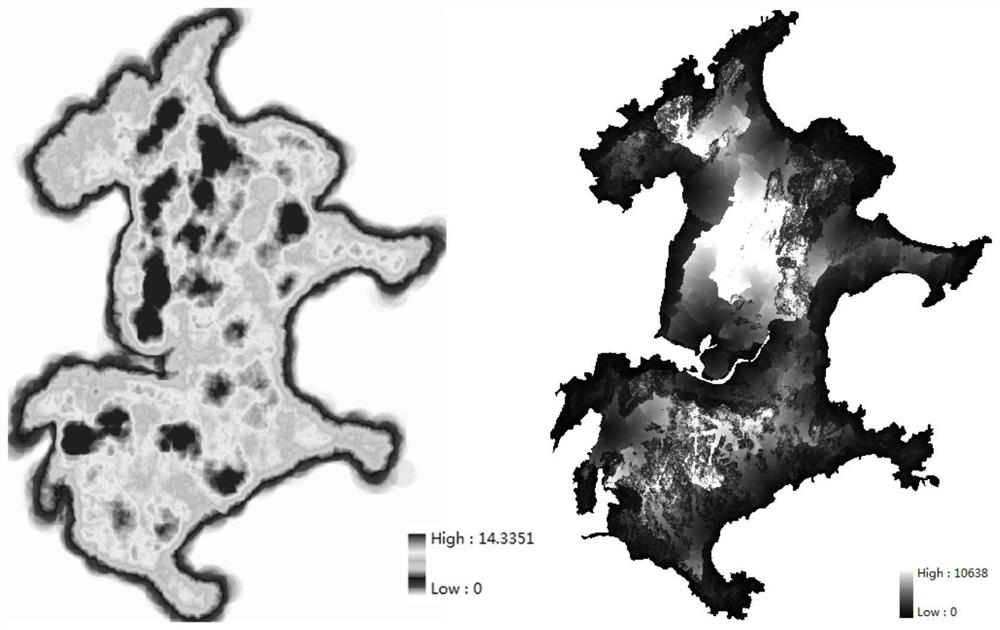
[0066] 2) Perform qualitative evaluation of soil erosion intensity, which includes four factors: vegetation coverage, land use type, gully density and optimal terrain factor; extract vegetation coverage from the original remote sensing image obtained in step 1); use maximum likelihood Classification divides the land use types in th...


PUM


Abstract

The invention discloses a water and soil loss quantitative monitoring method based on multi-source data and multi-temporal data, and the method comprises the following implementation steps: 1) obtaining a remote sensing image of an area to be monitored, carrying out atmospheric correction of the original remote sensing image, and obtaining the surface reflectance value of the image according to the theory and method of a COST model; 2) performing qualitative evaluation on the water and soil loss intensity, wherein four factors including vegetation coverage, land utilization type, gully density and optimal terrain factor are included; 3) performing quantitative evaluation on the water and soil loss intensity by utilizing remote sensing and GIS (Geographic Information System) technologies in combination with multi-source data, and calculating and outputting an annual average soil loss amount estimated value A of the to-be-monitored area according to a calculation formula A = R * K * LS * C * P of a USLE model; the invention has the advantages of being accurate in estimation result, good in universality and capable of accurately reflecting the rule that water and soil loss changes along with time and achieving long-term dynamic monitoring of regional water and soil loss.

Description

technical field [0001] The invention relates to the field of water and soil loss risk assessment, in particular to a remote sensing dynamic monitoring method for water and soil loss based on the USLE equation. Background technique [0002] Soil erosion refers to the movement of soil out of the soil due to water erosion or wind force, resulting in a decline in soil fertility, serious or even complete loss of soil fertility. However, to control soil erosion, we must clarify the scope and degree of soil erosion. Only in this way can targeted and effective soil erosion control be carried out. [0003] After serious soil erosion occurred in the early 1930s in the United States, the Soil Conservation Bureau and the National Laboratory of Soil and Water Conservation were established, and a large number of meticulous research work was carried out. After more than 30 years of hard work, in 1965, the famous Universal Soil Loss Equation (UniversalSoilLossEquation, USLE) was obtained....

Claims


Application Information

Patent Timeline
IPC IPC(8): G06K9/00G06Q10/06G06K9/62G06F30/27
CPCG06Q10/0635G06F30/27G06F18/2135G06F18/24Y02A40/22
Inventor 沙晋明徐赛萍李小梅吴龙滨王金亮包忠聪
Owner FUJIAN NORMAL UNIV
Learn More