Sea ice seawater remote sensing classification method, device and electronic equipment

A seawater and remote sensing technology, applied in the field of remote sensing applications, can solve problems such as single classification technology and inability to classify sea ice and seawater, and achieve the effect of improving efficiency and accuracy

Active Publication Date: 2021-11-05
NAT SATELLITE OCEAN APPL SERVICE +1
View PDF6 Cites 0 Cited by
  • Summary
  • Abstract
  • Description
  • Claims
  • Application Information

AI Technical Summary

Problems solved by technology

However, the current joint classification technology based on HY-2 series satellite correction radiomet

Method used


Image

  • Sea ice seawater remote sensing classification method, device and electronic equipment
  • Sea ice seawater remote sensing classification method, device and electronic equipment
  • Sea ice seawater remote sensing classification method, device and electronic equipment

Examples


Embodiment 1

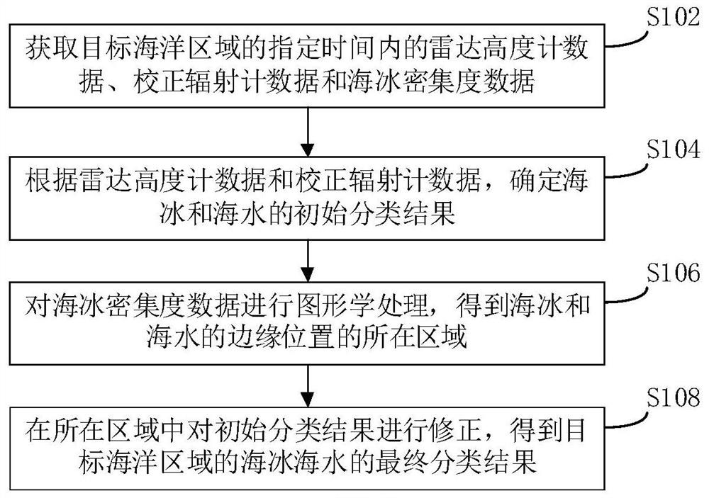
[0035] In order to facilitate the understanding of the embodiment of the present invention, a remote sensing classification method for sea ice and seawater disclosed in the embodiment of the present invention is first introduced in detail, as shown in figure 1 As shown, the method includes the following steps:

[0036]Step S102, acquiring radar altimeter data, corrected radiometer data and sea ice density data within a specified time in the target ocean area.

[0037] In actual implementation, the above-mentioned target ocean area may be any ocean area on the earth. The radar altimeter data can be the radar altimeter L1B data of a certain period of HY-2B obtained from the Satellite Ocean Application Center. The calibration radiometer data may be calibration radiometer L1B data obtained from the Satellite Ocean Application Center. The sea ice density data are obtained from the OSI-SAF (Ocean and Sea Ice-Satellite Application Facility) database and the NSIDC (National Snow and...

Embodiment 2

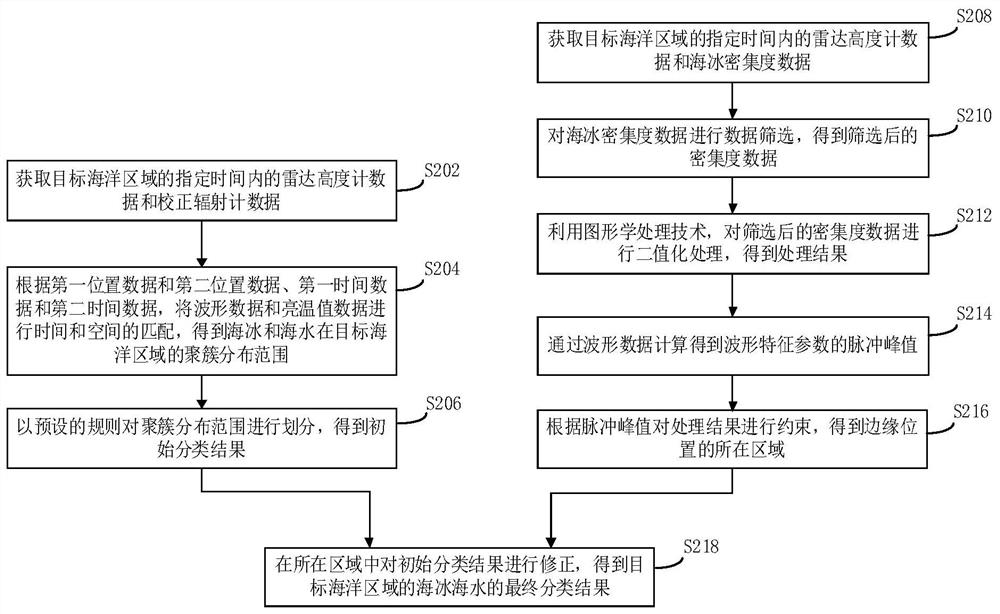
[0046] The embodiment of the present invention also provides another remote sensing classification method for sea ice and seawater, which is implemented on the basis of the method in the above embodiment; figure 2 Shown; The method includes the following specific steps:

[0047] Step S202, acquiring radar altimeter data and calibration radiometer data within a specified time in the target ocean area.

[0048] In a specific implementation, the specified time may be a pre-specified time period, for example, one year, one month, and so on. The above radar altimeter data includes waveform data, the first position data of the waveform data and the first time data of the waveform data; the corrected radiometer data includes brightness temperature value data, the second position data of the brightness temperature value data and the first time data of the brightness temperature value data. Two time data.

[0049] Specifically, the method of extracting the above data is: through mat...

Embodiment 3

[0071] Corresponding to the above-mentioned method embodiment, the embodiment of the present invention also provides a remote sensing classification device for sea ice and seawater, such as Figure 6 As shown, the device includes:

[0072] The data acquisition module 61 is configured to acquire radar altimeter data, corrected radiometer data and sea ice density data within a specified time in the target ocean area.

[0073] The first classification module 62 is configured to determine the initial classification results of sea ice and seawater according to the radar altimeter data and the calibration radiometer data.

[0074] The sea ice edge determination module 63 is used for graphically processing the sea ice density data to obtain the location of the edge position of sea ice and sea water;

[0075] The correction module 64 is configured to correct the initial classification result in the local area to obtain the final classification result of sea ice and seawater in the targ...


PUM


Abstract

The invention provides a sea ice seawater remote sensing classification method, a device and electronic equipment, and relates to the technical field of remote sensing application. The method comprises the steps: obtaining radar altimeter data, correction radiometer data and sea ice concentration data of a target ocean region within a specified time; determining an initial classification result of the sea ice and the seawater according to the radar altimeter data and the correction radiometer data; performing graphic processing on the sea ice concentration data to obtain areas where the edge positions of the sea ice and the seawater are located; and correcting the initial classification result in the region to obtain a final classification result of the sea ice seawater in the target ocean region. According to the embodiment of the invention, the radar altimeter data and the correction radiometer data are combined, so that the sea ice and seawater classification efficiency and precision are improved.

Description

technical field [0001] The invention relates to the technical field of remote sensing applications, in particular to a remote sensing classification method, device and electronic equipment for sea ice and seawater. Background technique [0002] Sea ice is an amplifier of global climate change, and changes in polar sea ice have an important impact on global climate change, so it is of great significance to accurately distinguish between sea ice and seawater. Early data on sea ice and seawater types could only be obtained through on-the-spot surveys, and later developed to classify seawater and sea ice based on information such as optical and SAR remote sensing images, or echo waveforms from satellite radar altimeters. However, the current joint classification technology based on HY-2 series satellite correction radiometers and radar altimeters is single, and cannot accurately and efficiently classify sea ice and seawater. Contents of the invention [0003] In view of the a...

Claims


Application Information

Patent Timeline
IPC IPC(8): G06K9/62G06T7/11G06T7/181
CPCG06T7/11G06T7/181G06T2207/10044G06F18/24
Inventor 蒋城飞林明森曹瑞雪马小峰贾永军王其茂石立坚安文涛崔利民曾涛
Owner NAT SATELLITE OCEAN APPL SERVICE
Why Eureka
Try Eureka