Remote sensing-based estuary coast hydrodynamic information enhanced display method

An information enhancement and display method technology, applied in the field of remote sensing, can solve the problems of unsightly basic images, dark water bodies, and difficulty in highlighting the flow state information of the estuary, and achieve the effect of bright colors, good layers and rich images.

Active Publication Date: 2021-11-05
PEARL RIVER HYDRAULIC RES INST OF PEARL RIVER WATER RESOURCES COMMISSION
View PDF6 Cites 0 Cited by
  • Summary
  • Abstract
  • Description
  • Claims
  • Application Information

AI Technical Summary

Problems solved by technology

The combination of remote sensing image bands and post-imaging stretching enhancement will have a direct impact on the interpretation results. In image processing, the combination of red, green, and blue true color bands or the near-infrared, red, and green False color bands are combined for imaging, and the image is stretched and enhanced as a whole, and finally the basic map for flow analysis is made; if the red, green, and blue true color bands are used for imaging, the

Method used


Image

  • Remote sensing-based estuary coast hydrodynamic information enhanced display method
  • Remote sensing-based estuary coast hydrodynamic information enhanced display method
  • Remote sensing-based estuary coast hydrodynamic information enhanced display method

Examples


Embodiment Construction

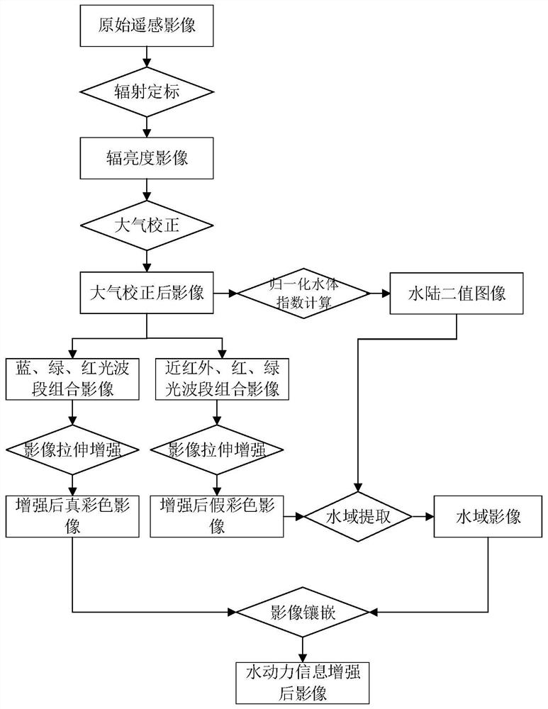
[0036] The present invention will be further described below in conjunction with the accompanying drawings. It should be noted that this embodiment is based on the technical solution, and provides detailed implementation and specific operation process, but the protection scope of the present invention is not limited to the present invention. Example.

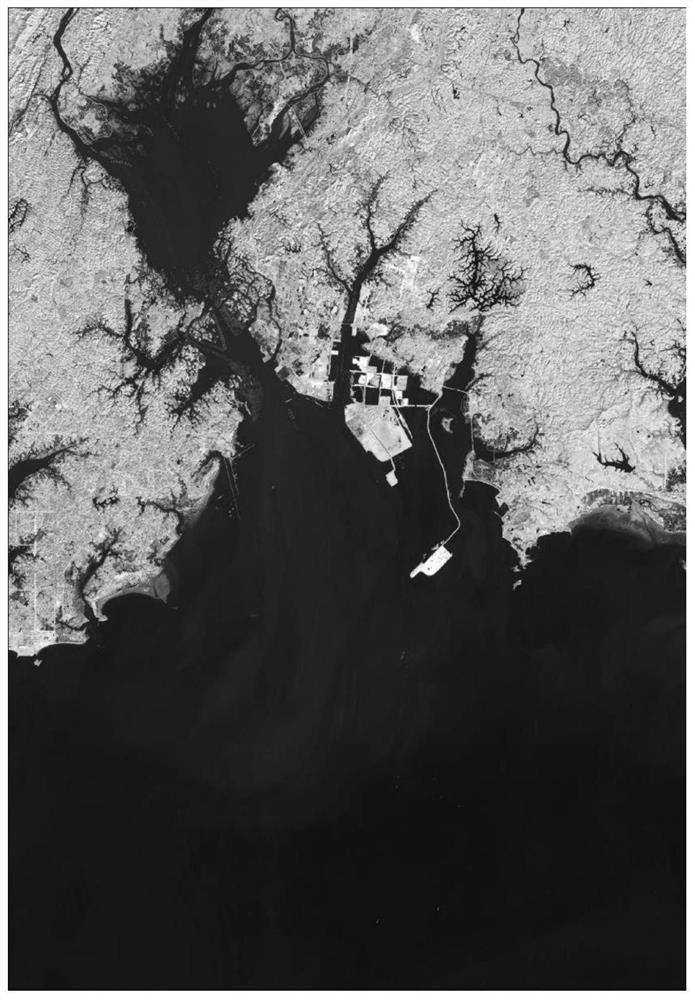
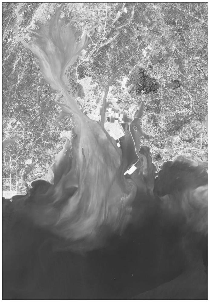
[0037] This embodiment takes the Landsat8 satellite image of Guangxi Qinjiang estuary on December 4, 2013, and the GF1 satellite image data of Guangdong Pearl River estuary on December 27, 2016 as examples to describe a method of enhanced display of estuary and coast hydrodynamic information based on remote sensing. The specific process of the method is as follows figure 1 Shown:

[0038] 1. Obtain radiometric calibration parameters of satellite data: For foreign satellite image data, the calibration parameters are generally read from the header file; domestic satellite data calibration parameters change frequently, and can be ...


PUM


Abstract

The invention discloses a remote sensing-based estuary coast hydrodynamic information enhanced display method, which comprises the following steps of: based on an optical remote sensing image and according to land vegetation and water spectral characteristics, firstly imaging the remote sensing image in different wave band combination modes and performing enhanced display, and extracting a water area of a false color composite image; and embedding the water area and the true color land area, and finally obtaining an estuary coast area hydrodynamic information analysis map which highlights the water flow state information and truly expresses the land area information. Compared with the prior art, the hydrodynamic analysis image processed through the method is bright in color, rich in image and good in hierarchy, water hydrodynamic information can be displayed in an enhanced mode, and meanwhile land vegetation information can be truly expressed.

Description

technical field [0001] The invention relates to the technical field of remote sensing, in particular to a remote sensing-based enhanced display method for estuary and coastal hydrodynamic information. Background technique [0002] Estuary and coastal areas are often densely populated and highly economically developed areas. At the same time, they are affected by multiple factors such as runoff, tidal currents, waves, and sediment. Accurately grasping dynamic information such as tidal flow direction, flow state, and sediment transport characteristics in the estuary and coastal areas is a prerequisite for carrying out scientific research, planning formulation, and engineering demonstrations related to estuary and coastal areas. [0003] Compared with the traditional station-based hydrological observation method, the use of remote sensing technology to carry out hydrodynamic monitoring of flow regimes and sediments in estuary and coastal areas has the advantages of wide monitor...

Claims


Application Information

Patent Timeline
IPC IPC(8): G06T5/00G06T7/80G06T7/90
CPCG06T5/006G06T5/007G06T7/80G06T7/90G06T2207/10032
Inventor 杨留柱王照良张勇强刘培喻丰华邹华志林中源何颖清潘洪州许伟黄鹏飞魏乾坤闫军波邓月运易丽莎
Owner PEARL RIVER HYDRAULIC RES INST OF PEARL RIVER WATER RESOURCES COMMISSION
Why Eureka
Try Eureka