
Three-dimensional ground penetrating radar real-time interpretation method and system for underground space data

A ground-penetrating radar and underground space technology, which is applied in the field of ground-penetrating radar interpretation, can solve the problems of layer boundary shape image void, misrecognition, and reduce the accuracy of interpretation results, etc., to meet real-time requirements and response speed Fast, to avoid the effect of misidentification

Active Publication Date: 2021-12-07
深圳安德空间技术有限公司
View PDF8 Cites 3 Cited by
  • Summary
  • Abstract
  • Description
  • Claims
  • Application Information

AI Technical Summary

Problems solved by technology

[0003] First, non-real-time data processing and artificial intelligence interpretation cannot achieve high-efficiency on-site parallelism of data collection, data processing, and artificial intelligence interpretation, so that it cannot meet the requirements of emergency projects and large-area blind test projects
Second, the artificial intelligence interpretation based only on the vertical slice image of ground penetrating radar is likely to cause more misidentifications, thereby reducing the accuracy of the interpretation results.
Third, the artificial intelligence interpretation / classification method based on the simple superposition of vertical slices and horizontal slices of ground penetrating radar is also likely to cause more misidentifications, thereby reducing the accuracy of interpretation results. For emptying, etc.

Method used


Image

  • Three-dimensional ground penetrating radar real-time interpretation method and system for underground space data
  • Three-dimensional ground penetrating radar real-time interpretation method and system for underground space data
  • Three-dimensional ground penetrating radar real-time interpretation method and system for underground space data

Examples


Embodiment Construction

[0050] The preferred embodiments of the present invention will be further described in detail below in conjunction with the accompanying drawings.

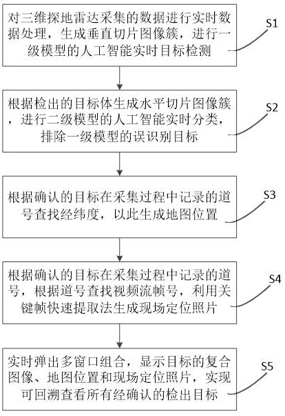
[0051] Such as figure 1 As shown, this example provides a 3D GPR real-time interpretation method for underground space data, including the following steps:

[0052] Step S1, performing real-time data processing on the real-time data collected by the 3D ground penetrating radar, generating vertical slice image clusters, and performing artificial intelligence real-time target detection of the first-level model;

[0053] Step S2, generating horizontally sliced ​​image clusters according to the detected target body, performing artificial intelligence real-time classification of the secondary model, and eliminating misrecognized targets of the primary model;

[0054] Step S3, searching for the latitude and longitude according to the track number recorded in the collection process of the confirmed target, so as to generate the map posi...


PUM


Abstract

The invention provides a three-dimensional ground penetrating radar real-time interpretation method and system for underground space data, wherein the method comprises the steps: s1, carrying out the real-time data processing of real-time data collected by a three-dimensional ground penetrating radar, generating a vertical slice image cluster, and carrying out the target detection of a first-stage model; s2, generating a horizontal slice image cluster according to the detected target body, and carrying out the real-time classification of a secondary model; s3, searching longitude and latitude according to the track number recorded in the collection process of the confirmed target, and generating a map position; s4, searching a video stream frame number according to the channel number recorded by the confirmed target in the acquisition process, and generating an on-site positioning picture by using a key frame rapid extraction method; s5, popping up a multi-window combination in real time, and displaying the instantly detected composite image of the target, the map position and the field positioning photo. According to the method, the requirements of emergency projects and large-area blind test projects on real-time performance can be well met, and the problem of misrecognition can be effectively avoided.

Description

technical field [0001] The present invention relates to a ground-penetrating radar interpretation method, in particular to a real-time three-dimensional ground-penetrating radar interpretation method for underground space data, and to a system using the three-dimensional ground-penetrating radar real-time interpretation method for underground space data . Background technique [0002] Ground Penetrating Radar, also known as ground penetrating radar, is a non-destructive geophysical detection technology that uses high-frequency electromagnetic waves to determine the structure of shallow strata. By emitting high-frequency pulsed electromagnetic waves (frequency between 1MHz-1GHz) to detect underground media and determine the distribution of underground media, it has the characteristics of simple operation, high detection accuracy, no damage, and fast acquisition speed. It is the most active engineering detection and survey at present. The detection technology has been widely ...

Claims


Application Information

Patent Timeline
IPC IPC(8): G01S7/41G01V3/12G01V3/38G06K9/00G06K9/62G06K9/32
CPCG01S7/41G01S7/417G01V3/12G01V3/38G06F18/24
Inventor 项芒董超唐剑秦鹏黄钰琳
Owner 深圳安德空间技术有限公司
Learn More